
A tunnel is an underground or undersea passageway. It is dug through surrounding soil, earth or rock, or laid under water, and is usually completely enclosed except for the two portals common at each end, though there may be access and ventilation openings at various points along the length. A pipeline differs significantly from a tunnel, though some recent tunnels have used immersed tube construction techniques rather than traditional tunnel boring methods.

The Rock of Gibraltar is a monolithic limestone mountain 426 m (1,398 ft) high dominating the western entrance to the Mediterranean Sea. It is situated near the end of a narrow 9 kilometres (5.6 mi) long promontory stretching due south into the Mediterranean Sea and is located within the British territory of Gibraltar, and is 27 km north-east of Tarifa, Spain, the southwestern tip of Europe on the Iberian Peninsula. The rock serves as an impregnable fortress and contains a labyrinthine network of man-made tunnels known as the Tunnels of Gibraltar. Most of the Rock's upper area comprises a nature reserve which is home to about 300 Barbary macaques. It is a major tourist attraction.

A Nissen hut is a prefabricated steel structure originally for military use, especially as barracks, made from a 210° portion of a cylindrical skin of corrugated iron. It was designed during the First World War by the Canadian-American-British engineer and inventor Major Peter Norman Nissen. It was used also extensively during the Second World War and was adapted as the similar Quonset hut in the United States.

A dugout or dug-out, also known as a pit-house or earth lodge, is a shelter for humans or domesticated animals and livestock based on a hole or depression dug into the ground. Dugouts can be fully recessed into the earth, with a flat roof covered by ground, or dug into a hillside. They can also be semi-recessed, with a constructed wood or sod roof standing out. These structures are one of the most ancient types of human housing known to archaeologists, and the same methods have evolved into modern "earth shelter" technology.

Croesor quarry is a large underground slate mine in North Wales which was served by Croesor Tramway. Small scale quarrying began in the 1846, and by 1861, there were two companies in operation. They amalgamated in 1865, a year after the quarry was connected to the newly opened Croesor Tramway. Much money was invested in development work, but volumes of useful slate produced were small, amounting to just 226 tons in 1868. Access to the underground workings was by a single adit, and the surface mill was powered by two water wheels. A change of ownership in 1875 did little to improve the profitability of the quarry, and it closed in 1878 or 1882.

The military history of Gibraltar during World War II exemplifies Gibraltar's position as a British fortress from the early-18th century onwards and as a vital factor in British military strategy, both as a foothold on the continent of Europe, and as a bastion of British sea power. During World War II, Gibraltar served a vital role in both the Atlantic Theatre and the Mediterranean Theatre, controlling virtually all naval traffic moving between the Mediterranean Sea and the Atlantic Ocean.

Maraetai Power Station is a hydroelectric power station on the Waikato River, in the North Island of New Zealand. It is the fifth of the eight hydroelectric power stations on the Waikato River, and at 360 MW, is the largest hydroelectric station on the Waikato.

Nun's Well is an ancient underground water reservoir in the British Overseas Territory of Gibraltar. It is located at Europa Point, and is thought to be of the Moorish period. It represents some of the earliest evidence of an artificial water supply in Gibraltar. The name of the cistern is thought to be derived from the nuns associated with the Shrine of Our Lady of Europe. In the eighteenth century, Nun's Well supplied the military with water. In the early nineteenth century, it provided water for the brewery that was built next door. In 1988, the Royal Engineers constructed what is now the main building, which has a castle-like appearance. Nun's Well became the focus of controversy during the 2010-2011 restoration of the site.

Lord Airey's Shelter is a subterranean military shelter in the British Overseas Territory of Gibraltar. It is located near the southern end of the Upper Rock Nature Reserve, adjacent to Lord Airey's Battery. It was named after the Governor of Gibraltar, General Sir Richard Airey. The tunnel system for the shelter was chosen as the site for the highly classified, Second World War military operation known as Operation Tracer.

Wilson's Cave is a cave in the British Overseas Territory of Gibraltar.

Signal Hill Battery or Signal Battery was an artillery battery in the British Overseas Territory of Gibraltar. The battery was mounted high on the rock. Little remains today as the Gibraltar Cable Car top station was built on the site of the old battery.
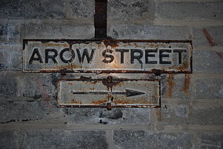
AROW Street is a tunnel in Gibraltar that was excavated in 1942. The tunnel, like Gibraltar's Great North Road, was large enough to take Army ammunition trucks.

The Gibraltar peninsula, located at the far southern end of Iberia, has great strategic importance as a result of its position by the Strait of Gibraltar where the Mediterranean Sea meets the Atlantic Ocean. It has repeatedly been contested between European and North African powers and has endured fourteen sieges since it was first settled in the 11th century. The peninsula's occupants – Moors, Spanish, and British – have built successive layers of fortifications and defences including walls, bastions, casemates, gun batteries, magazines, tunnels and galleries. At their peak in 1865, the fortifications housed around 681 guns mounted in 110 batteries and positions, guarding all land and sea approaches to Gibraltar. The fortifications continued to be in military use until as late as the 1970s and by the time tunnelling ceased in the late 1960s, over 34 miles (55 km) of galleries had been dug in an area of only 2.6 square miles (6.7 km2).

The Great North Road is a large road tunnel in the British Overseas Territory of Gibraltar. It was constructed by the British military during World War II inside the Rock of Gibraltar and remains property of the Ministry of Defence to this day. The road allowed lorries to travel from the north to the south of Gibraltar entirely within the Rock. The tunnel still contains the remains of World War II buildings such as Nissen huts, kitchens, offices as well as a generating station and period anti-submarine nets.

The tunnels of Gibraltar were constructed over the course of nearly 200 years, principally by the British Army. Within a land area of only 2.6 square miles (6.7 km2), Gibraltar has around 34 miles (55 km) of tunnels, nearly twice the length of its entire road network. The first tunnels, excavated in the late 18th century, served as communication passages between artillery positions and housed guns within embrasures cut into the North Face of the Rock. More tunnels were constructed in the 19th century to allow easier access to remote areas of Gibraltar and accommodate stores and reservoirs to deliver the water supply of Gibraltar.
The Iris hut is a prefabricated steel structure used by the British military predominantly during the early part of the Second World War. They served as barracks, workshops, and storage facilities in World War II Great Britain.

Tofana di Rozes is a mountain of the Dolomites in the Province of Belluno, Veneto, Italy. Located west of the resort of Cortina d'Ampezzo, the mountain's giant three-edged pyramid shape and its vertical south face, above the Falzarego Pass, makes it the most popular peak in the Tofane group, and one of the most popular in the Dolomites.
Parc Quarry was a compact underground slate quarry in the Croesor Valley, Gwynedd, North Wales. It was connected to the Croesor Tramway, which ran through the valley. The quarry concentrated on producing specialist slate products, rather than roofing slates, and was managed for much of the time by the innovator Moses Kellow. It operated for about 50 years, from 1870 to 1920.

Tunnels are dug in types of materials varying from soft clay to hard rock. The method of tunnel construction depends on such factors as the ground conditions, the ground water conditions, the length and diameter of the tunnel drive, the depth of the tunnel, the logistics of supporting the tunnel excavation, the final use and shape of the tunnel and appropriate risk management. Tunnel construction is a subset of underground construction.

The Twynham hut was developed by the British War Office in 1959 as a replacement for the Nissen hut which was first used in 1916. It was constructed of individual 8-foot (2.4 m) bays which made the roof stronger than that of its predecessor. Huts are known to have been constructed in lengths between 16 feet (4.9 m) and 128 feet (39 m). Although four times the cost of Nissen huts the Twynham hut was considered more comfortable and aesthetically pleasing; it also had twice the design life and could be fitted with air conditioning. The huts remained in use until at least 1982.


