Fort Fremont

Last updated
Fort Fremont Battery
Fort Fremont Battery.jpg
USA South Carolina location map.svg
Red pog.svg
Location in South Carolina
Usa edcp location map.svg
Red pog.svg
Location in United States
Nearest city Frogmore, South Carolina
Coordinates 32°18′20″N80°38′36″W / 32.30556°N 80.64333°W / 32.30556; -80.64333
Area2.8 acres (1.1 ha)
Built1899 (1899)
Built by US Army Corps of Engineers
Architectural styleCoastal Fortification
MPS Historic Resources of St. Helena Island c. 1740-c. 1935 MPS
NRHP reference No. 88001821 [1]  (original)
100006498  (increase)
Significant dates
Added to NRHPMay 5, 2010
Boundary increaseMay 6, 2021

Fort Fremont (sometimes misspelled 'Freemont' [2] ) was a military installation on Saint Helena Island, Beaufort County, South Carolina. The fort and battery is historically significant as an example of late nineteenth and early twentieth century military architecture and as one of two surviving coastal fortifications in the United States intact from the Spanish–American War era. [3] [4]

Contents

Construction

The construction of additional coastal batteries was authorized by Congress under the $50 million Harbor Fortification Defense Act of 1898 due to the Spanish–American War. Fort Fremont was built by the Corps of Engineers on condemned private property, with construction starting in 1899. [5] The Corps of Engineers hired labor from the Beaufort area to build the military complex.

Details

The fort was named after John C. Fremont, the first presidential candidate of the Republican Party in 1856. Later, Fremont was a Civil War general.

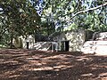
The complex at Fort Fremont consisted of almost 170 acres (69 ha) of land with numerous outbuildings, including an Administration building, guard house, barracks, hospital, stable, mess hall, bakery, commissary, post exchange, lavatory, and water tower. The garrison's single artillery company operated three 10-inch disappearing guns and two 4.7-inch rapid fire guns. Much of the bastions and the concrete emplacements for the guns remain today. [6]

In 1900, Fort Fremont was turned over to the Coastal Artillery.

Deactivation

As early as 1906 the War Department gave serious consideration to the closing of Fort Fremont, due to budgetary constraints.

Regarding reports that Fort Fremont would be sold or abandoned, the April 16, 1912 issue of the Beaufort Gazette quoted the Assistant Secretary of War: "... I have the honor to inform you that no such action is contemplated at present." A small detachment of soldiers had been serving as caretakers at the fort after troops stationed there had been reassigned to Galveston the previous year.

A December 7, 1921 Charleston News and Courier article reported that the U.S. Treasury Department requested Fort Fremont from the U.S. War Department for use as a quarantine station. The property had by then been placed on the Secretary of War's list of properties no longer needed for military purposes and available for sale. Fort Fremont was subsequently deactivated as a military installation in 1921.

The fort was decommissioned and sold at public auction by the War Department in 1930. The Fort Fremont Battery was listed in the National Register of Historic Places (NRHP) on May 5, 2010. [1] Today the fort is a Historical Preserve. [7] Only the 10 inch battery, the rapid-fire battery, and the brick hospital built in 1906 survive. All the other structures were made of wood and were demolished at various points before 1989, when documentation was submitted to the NRHP. The documentation states that "Fort Fremont is one of only two extant Spanish–American War fortifications which retain their character from that period." [8]

Related Research Articles

<span class="mw-page-title-main">Fort Schuyler</span> Landmark, Bronx, New York

Fort Schuyler is a preserved 19th century fortification in the New York City borough of the Bronx. It houses a museum, the Stephen B. Luce Library, and the Marine Transportation Department and Administrative offices of the State University of New York Maritime College. It is considered one of the finest examples of early 19th century fortifications. The fort was named in honor of Major General Philip Schuyler of the Continental Army.

<span class="mw-page-title-main">Fort Macon State Park</span> State park in North Carolina, United States

Fort Macon State Park is a North Carolina state park in Carteret County, North Carolina, in the United States. Located on Bogue Banks near Atlantic Beach, the park opened in 1936. Fort Macon State Park is the second most visited state park in North Carolina, with an annual visitation of 1.3 million, despite being one of the smallest state parks in North Carolina with 424 acres (1.72 km2). Fort Macon was built as part of the Third System of US fortifications, and was preceded by Fort Hampton of the Second System.

<span class="mw-page-title-main">Beacon Hill Battery</span> Late-19th and 20th century coastal fortification

Beacon Hill Battery is a late-19th and 20th century coastal fortification that was built to defend the port of Harwich, Essex. It is a scheduled ancient monument.

<span class="mw-page-title-main">Fort Moultrie</span> United States historic place

Fort Moultrie is a series of fortifications on Sullivan's Island, South Carolina, built to protect the city of Charleston, South Carolina. The first fort, formerly named Fort Sullivan, built of palmetto logs, inspired the flag and nickname of South Carolina, as "The Palmetto State". The fort was renamed for the U.S. patriot commander in the Battle of Sullivan's Island, General William Moultrie. During British occupation, in 1780–1782, the fort was known as Fort Arbuthnot.

<span class="mw-page-title-main">Fort McClary</span> United States historic place

Fort McClary is a former defensive fortification of the United States military located along the southern coast at Kittery Point, Maine at the mouth of the Piscataqua River. It was used throughout the 19th century to protect approaches to the harbor of Portsmouth, New Hampshire and the Portsmouth Naval Shipyard in Kittery. The property and its surviving structures are now owned and operated by the State of Maine as Fort McClary State Historic Site, including a blockhouse dating from 1844.

<span class="mw-page-title-main">Fort Carroll</span> United States historic place

Fort Carroll is a 3.4-acre (1.4 ha) artificial island and abandoned hexagonal sea fort in the middle of the Patapsco River, just south of Baltimore, Maryland. It is named for Charles Carroll of Carrollton (1737–1832), a signer of the Declaration of Independence.

<span class="mw-page-title-main">Fort Mott (New Jersey)</span>

Fort Mott, located in Pennsville, Salem County, New Jersey, United States, was part of the Harbor Defenses of the Delaware, a three-fort defense system designed for the Delaware River during the Reconstruction era and Endicott program modernization periods following the American Civil War and in the 1890s. The other two forts in the system were Fort Delaware on Pea Patch Island and Fort DuPont in Delaware City, Delaware. It was active for the Spanish American War and World War I. It was closed in 1944, and sold to the state of New Jersey to become Fort Mott State Park.

Fort Terry was a coastal fortification on Plum Island, a small island just off Orient Point, New York, United States. This strategic position afforded it a commanding view over the Atlantic entrance to the commercially vital Long Island Sound. It was established in 1897 and used intermittently through the end of World War II. In 1952, it became a military animal and biological warfare (BW) research facility, moving to civilian control in 1954 as the Plum Island Animal Disease Center. Despite the new civilian control, the biological warfare mission continued until 1969, when the US officially ended offensive BW research. The island is now being considered for sale or conversion to a wildlife refuge. Fort Terry was listed on the National Register of Historic Places in 2021.

<span class="mw-page-title-main">Fort Crockett</span> United States historic place

Fort Crockett is a government reservation on Galveston Island overlooking the Gulf of Mexico originally built as a defense installation to protect the city and harbor of Galveston and to secure the entrance to Galveston Bay, thus protecting the commercial and industrial ports of Galveston and Houston and the extensive oil refineries in the bay area. The facility is now managed by the US NOAA National Marine Fisheries Service, and hosts the Bureau of Commercial Fisheries Laboratory, the Texas Institute of Oceanography, as well as some university facilities. The area still contains several historical buildings and military fortifications.

<span class="mw-page-title-main">Fort Miley Military Reservation</span>

The Fort Miley Military Reservation, in San Francisco, California, sits on Point Lobos, one of the outer headlands on the southern side of the Golden Gate. Much of the site is part of the Golden Gate National Recreation Area, while the grounds and buildings that were converted into the San Francisco VA Medical Center are administered by the Veterans Health Administration of the US Department of Veterans Affairs.

<span class="mw-page-title-main">Fort Wetherill</span> Historic site in Rhode Island, United States

Fort Wetherill is a former coast artillery fort that occupies the southern portion of the eastern tip of Conanicut Island in Jamestown, Rhode Island. It sits atop high granite cliffs, overlooking the entrance to Narragansett Bay. Fort Dumpling from the American Revolutionary War occupied the site until it was built over by Fort Wetherill. Wetherill was deactivated and turned over to the State of Rhode Island after World War II and is now operated as Fort Wetherill State Park, a 51-acre (210,000 m2) reservation managed by the Rhode Island Department of Environmental Management.

<span class="mw-page-title-main">Fort DuPont</span>

Fort DuPont, named in honor of Rear Admiral Samuel Francis Du Pont, is located between the original Delaware City and the modern Chesapeake and Delaware Canal on the original Reeden Point tract, which was granted to Henry Ward in 1675. Along with two other forts of the Harbor Defenses of the Delaware, it defended the Delaware River and the water approach to Philadelphia from 1900 through 1942. In 1992 a portion was redesignated as Fort DuPont State Park, which became Delaware's 13th state park. In 2016, the acreage which is not in the state park system was annexed into Delaware City.

Frogmore is an unincorporated community on St. Helena Island in Beaufort County, South Carolina, United States, along U.S. Route 21.

<span class="mw-page-title-main">Fort Nepean</span>

Fort Nepean is a former defensive facility occupying part of Point Nepean, Victoria, Australia. It was part of a network of fortifications, commanded from Fort Queenscliff, protecting the narrow entrance to Port Phillip. It is now part of Point Nepean National Park and a local tourist attraction.

<span class="mw-page-title-main">Fort McKinley (Maine)</span> United States historic place

Fort McKinley is a former United States Army coastal defense fort on Great Diamond Island, Maine in Casco Bay, which operated from 1873 to 1947. It was named for President William McKinley. It included a sub-post, Fort Lyon, on Cow Island, just north of Great Diamond Island. Fort Lyon was named for Nathaniel Lyon. Both forts were part of the Coast Defenses of Portland, renamed the Harbor Defenses of Portland in 1925, a command which protected Portland's port and naval anchorage 1895-1950. In 1946 Fort Lyon was closed and turned over to the City of Portland. After Fort McKinley's closure it was transferred to the United States Navy, which sold the site to private interests in 1961. The Fort McKinley Historic District was listed on the National Register of Historic Places in 1985.

<span class="mw-page-title-main">Battery Steele</span>

Battery Steele is a United States military fortification on Peaks Island, Portland, Maine, in Casco Bay. Completed in 1942 as part of World War II, it is located on 14 acres (5.7 ha) on the oceanside area of the island, formerly part of the Peaks Island Military Reservation. It is named for Harry L. Steele, who was a Coast Artillery officer during World War I. It was armed with two 16-inch MkIIMI guns and, with a 12-inch gun battery at Fort Levett on Cushing Island, replaced all previous heavy guns in the Harbor Defenses of Portland. It was built to protect Casco Bay, particularly Portland harbor, from Kennebunk to Popham Beach in Phippsburg. According to Kim MacIsaac and historian Joel Eastman in An Island at War, “Battery Steele is not only the largest gun battery built on Peaks Island, but also an example of the largest battery ever built anywhere in the United States.” In 1995, after decades of non-use, the Peaks Island Land Preserve, a community land preservation group, formed to purchase the area and forever preserve it as a public space. On October 20, 2005, the property was listed on the National Register of Historic Places. Other coast defense structures on the island include fire control towers and the counterweight for a disappearing searchlight tower.

<span class="mw-page-title-main">Fort Fremont Hospital</span> United States historic place

Fort Fremont Hospital, located in Beaufort County, South Carolina, is significant due to its association with the nearby fort. The Colonial Revival building was built around 1906 as a replacement for the original hospital for the garrison. It is worth noting that the War Department planned to phase out the post at Fort Fremont Battery as early as 1906, the year that Fort Fremont Hospital was built. Since 1930, the year that the fort was decommissioned, the hospital has been privately owned. Fort Fremont Hospital was listed in the National Register of Historic Places on May 26, 1989.

<span class="mw-page-title-main">Fort Caswell Historic District</span> Historic district in North Carolina, United States

Located in North Carolina on the Atlantic Coast, the Fort Caswell Historic District encompasses 2 sites, 43 buildings, and 23 structures; it was added to the National Register of Historic Places in 2013. The fort itself was occupied by various branches of the U.S. armed forces for most of the period between 1836 and 1945 and is now a part of the North Carolina Baptist Assembly, a Christian retreat, owned and operated by the Baptist State Convention of North Carolina. It is accessible by the public to a limited extent per the conditions set forth by the Assembly’s Director.

<span class="mw-page-title-main">Fort Davis, County Cork</span>

Fort Davis, is a coastal defence fortification close to Whitegate, County Cork, Ireland. Together with similar structures at Fort Mitchel, Fort Camden (Crosshaven), and Templebreedy Battery, the fort was built to defend the mouth of Cork Harbour. Though used as a fortification from the early 17th century, the current structures of the 74-acre site date primarily from the 1860s. Originally named Fort Carlisle and operated by the British Armed Forces, the fort was handed-over to the Irish Defence Forces in 1938, and renamed Fort Davis. The facility is owned by the Department of Defence, and is used as a military training site with no public access.

<span class="mw-page-title-main">Fort Templebreedy</span> Defensive fort for Cork Harbour, Ireland

Fort Templebreedy, also known as Templebreedy Battery, was a coastal defence fortification close to Crosshaven, in County Cork, Ireland. Supplementing a number of earlier structures at Fort Camden and Fort Davis, the site was developed between 1904 and 1909 to defend the mouth of Cork Harbour. Used as a coastal artillery position until the 1940s, and as a military training camp until the late 20th century, many of the structures of the 37-acre site were dismantled over time, and part of the complex used as a pitch and putt course. In 2009, Cork County Council added the site to a proposed list of protected structures – though as of 2020 it remains in the ownership of the Department of Defence.

References

  1. 1 2 "National Register Information System". National Register of Historic Places . National Park Service. July 9, 2010.
  2. "About Fort Fremont". Beaufort County Library. Archived from the original on 29 January 2010. Retrieved 26 October 2009.
  3. Power, J. Tracy; Sherry Piland (February 16, 1988). "Fort Fremont Battery" (PDF). National Register of Historic Places - Nomination and Inventory. Retrieved 7 December 2012.
  4. "Fort Fremont Battery, Beaufort County (off Lands End Rd., St. Helena Island)". National Register Properties in South Carolina. South Carolina Department of Archives and History. Retrieved 7 December 2012.
  5. NOTE: Former owners of portions of the condemned land were Ellen A. Crofut, F.A. Dran, Jacob Meyers, Jack Freeman, July Fripp, Andrew Jenkins and Ellen Williams.
  6. NOTE: The March 2, 1899 issue of The Palmetto Post told that "a large force of laborers" was at work on the fortifications, that the 4.7-inch guns had already been mounted, and the emplacements had been completed for the larger weapons.
  7. "Fort Fremont Historical Preserve". Friends of Fort Fremont. Retrieved 3 June 2019.
  8. "Beaufort County Library, SC -- About Fort Fremont -- St. Helena Island, SC". Archived from the original on 2010-01-29. Retrieved 2009-09-27.