Fortifications of Guernsey

Last updated

The island of Guernsey has been fortified for several thousand years, the number of defence locations and complexity of the defence increasing with time, manpower and the improvements in weapons and tactics.

Contents

Being in the front line of many wars, invasion was almost always a threat and the best locations for defence were being constantly rebuilt with older constructions being re-used and improved.

1804 Martello Tower re-used within 1943 Stutzpunkt Rotenstein, Fort Hommet Guernsey July 2010 62, Fort Hommet.jpg
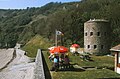
1804 Martello Tower re-used within 1943 Stützpunkt Rotenstein, Fort Hommet

Early defences

The first form of defences comprised safe locations for the islanders to flee to in the event of an invasion. The headland at Jerbourg, the Castel fortress, the Chateau des Marais and the Vale Castle were probably the earliest.
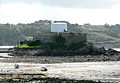
Ivy Castle in 1826 A Guide to the Island of Guernsey 1826 Ivy Castle.jpg
Ivy Castle in 1826
Castle Cornet Castle Cornet Guernsey.jpg
Castle Cornet

Castle Cornet was started in the late 13th Century on an islet accessible at low tide, outside Saint Peter Port. [1] :144–7 It would serve as the main base for the Governor of Guernsey, the commander of the Island's military forces, for many centuries.

The Guernsey militia was formed in 1337 and would continue until disbanded in 1946. It was compulsory for all men to belong to the militia. They trained weekly and for six centuries provided the main defensive force for the island.

A French invasion in 1338 captured the whole island including Castle Cornet, which dates back to at least 1256. Two years later the island was recaptured by English forces after the French navy was crippled at the Battle of Sluys and in August 1345 Castle Cornet was also recaptured. 13 years later the castle was again captured by the French before being evicted the following year.

In 1350 the King Edward ordered walls to be constructed around the town. The order was repeated when the work was not undertaken, but no evidence has been found of their existence. They would have linked the Tour Gand to the north with the Beauregard tower in the south. [4]

In May 1372 Owain Lawgoch a claimant to the Welsh throne, at the head of a free company, on behalf of France, attacked Guernsey, popularly called "La Descente des Aragousais". Owain Lawgoch withdrew after killing 400 of the Island militia, [5] The poem of the same name refers to the Vale Castle as the Château de l'Archange, the location of the last ditch stand against the insurgents. [6] :34

With the advent of cannon and gunpowder, defences, now based mainly around Castle Cornet were remodelled between 1545 and 1548.

During the Third English Civil War, Castle Cornet, the main fortification in the island, supported the King whilst the island supported Parliament, this resulted in a siege of the castle that lasted nine years, ending in 1651. The castle had been improved over the centuries with added walls, gates and batteries.

The King's Survey of the Channel Islands was commissioned by Charles II in 1679. The report produced by Colonel Legge a year later was a comprehensive account of the state of defence, harbours and civil jurisdiction of the Islands. In Guernsey, defences had been poorly maintained, Castle cornet having suffered a major explosion after a lightning strike in 1672. [7]

Main early defences, starting from St Peter Port and moving in a clockwise direction.

ParishPlace/NameNotesCoordinates
St Peter Port Castle Cornet ‡ £Main defence, built on islet and constructed of granite 49°27′10.8″N2°32′15.7″W / 49.453000°N 2.537694°W / 49.453000; -2.537694 ("Castle Cornet")
St Peter PortTown Wallspossibly built around 1350 [8] 49°27′14.3″N2°32′10″W / 49.453972°N 2.53611°W / 49.453972; -2.53611 ("St Peter Port")
St Peter PortGand towerexisted in the Pollet area, La Tourgand [4] 49°27′28″N2°32′7″W / 49.45778°N 2.53528°W / 49.45778; -2.53528 ("Tour Gand")
St Peter PortBeauregard towerbuilt in 1357 on Mignot Plateau, now demolished 49°27′12.4″N2°32′14.4″W / 49.453444°N 2.537333°W / 49.453444; -2.537333 ("Beauregard tower")
St Martin Jerbourg headland ʘearthen ditches and banks to protect headland [1] 49°25′37.2″N2°31′58.8″W / 49.427000°N 2.533000°W / 49.427000; -2.533000 ("Jerbourg")
ForestLa Corbière HeadlandA clifftop fortification that had fallen into disrepair by 1680 [7] 49°25′09.0″N2°36′46.9″W / 49.419167°N 2.613028°W / 49.419167; -2.613028 ("Corbière")
TortevalPezeries ‡ ʘFort first mentioned in 1680 [9] 49°26′13.5″N2°40′16.8″W / 49.437083°N 2.671333°W / 49.437083; -2.671333 ("Pezeries fort")
CastelHommet headland – Fort Hommet ʘfortification recorded in 1680 with one gun 49°28′27.8″N2°36′44.1″W / 49.474389°N 2.612250°W / 49.474389; -2.612250 ("Fort Hommet")
CastelInland fortress pre 600 A.D.possible earth and wood construction now demolished 49°27′30.7″N2°34′23.2″W / 49.458528°N 2.573111°W / 49.458528; -2.573111 ("Castel")
ValeLe Marchant headland – Fort L’Angle ‡ ʘsmall fort mentioned in 1680, renamed in 1805 Le Marchant 49°30′32″N2°31′7.2″W / 49.50889°N 2.518667°W / 49.50889; -2.518667 ("Fort le Marchant")
Vale Vale Castle ‡ ʘ [10] built on top of a rock outcrop, protected by 15C granite walls 49°29′6.5″N2°30′32.9″W / 49.485139°N 2.509139°W / 49.485139; -2.509139 (" Vale castle")
St Peter Port Chateau des Marais ‡ ʘbuilt in a swamp, a standard Motte and Bailey fort 49°28′18.9″N2°32′19.5″W / 49.471917°N 2.538750°W / 49.471917; -2.538750 ("Chateau des Marais")

Key ‡ Protected Monument [11] £ Accessible with fee ʘ Accessible

18th and early 19th Century

18th Century threats from France

L'Ancresse Loophole Tower no. 6 L'Ancresse Loophole Tower no. 6, Guernsey - channel-islands.geographs.org - 419.jpg
L'Ancresse Loophole Tower no. 6

Having lived with constant threats during the Seven Years' War (1754–63), threats of an invasion from France during the Anglo-French War (1778–83) resulted in additional artillery being brought to the Island and the construction of several forts, numerous batteries covering possible landing sites and fifteen Guernsey loophole towers built between 1778 and 1779, [12] The threat was real as an invasion of nearby Jersey resulted in the Battle of Jersey in Saint Helier in January 1781. Work started in 1782 on the massive Fort George, on the hill south of Town, it would take over three decades to complete. Guernsey granite was used for the majority of the gun platforms, forts and walls with embrasures often lined with brick.

A map was produced in 1787 for the Duke of Richmond as Master-General of the Ordnance to show all existing roads and military positions.

French Revolution and Napoleonic era defences

The French Revolution in 1789 added to the concerns in the Channel Islands and resulted in additional constructions and an increase in manpower.

The island militia of around 3,000 men provided both infantry and coastal artillery units. They were supplemented with regular British infantry battalions who rotated and were increased or reduced depending on the current threat to the island. Before the barracks were built in Fort George, islanders were required to provide accommodation for soldiers that could not be accommodated in Castle Cornet. Each Parish had its quota and if they were quartered in public houses or private dwellings, the parish authorities were liable for the cost. [13] :59 Non British units, which were not allowed on the UK mainland, were sometimes based in Guernsey, including from 1793 to 1796 French Royalists and in 1799, 6,000 Russian troops, who were quartered at Delancey. [14] :12 In 1796 Peter de Havilland, a Jurat was appointed superintendent of thirteen signal masts around the island, installed to give warning of approaching ships. [15] :45

Lieutenant-General John Doyle was appointed Lieutenant Governor of Guernsey in 1803. After declaring a "state of emergency" in 1804, [16] he undertook many works to improve the defence of the Island, including the draining of the Braye du Valle, improving some roads to military standard and building forts and batteries around the coast, including completing Fort George. Major-General Sir John Doyle was supported from 1810 by the new Bailiff, Peter de Havilland. The "emergency" lasted until 1815.

Doyle was instrumental in getting three Martello towers built in 1804–1805, as well as the reclaiming of Braye du Valle 1806–1808, the improved military roads with mile markers, for which he argued eloquently, against much opposition, [17] :48–58 and barracks which together gave the militia and regular units improved facilities to repel any invasion. [18]

The Royal Navy provided the first line of defence, Captain Sausmarez, in command of a Guernsey-based squadron consisting of three frigates, HMS Crescent (1784), HMS Druid (1783) and HMS Eurydice (1781), a lugger, and cutter frustrated a planned invasion by 20,000 French soldiers of the Channel Islands scheduled for February 1794, due to his vigilant eye [14] :9 Admiral James Saumarez was again put in charge of a squadron based in Guernsey from 1803 to 1808.

Defences

Land based defences, starting from St Peter Port and moving in a clockwise direction.

ParishPlace/NameNotesCoordinates
St Peter Port Castle Cornet ‡ £harbour defence, now a museum 49°27′10.8″N2°31′33.6″W / 49.453000°N 2.526000°W / 49.453000; -2.526000 ("Castle Cornet")
St Peter PortHavelet – Half Moon battery ʘbattery covering Havelet bay 49°27′0.7″N2°32′5″W / 49.450194°N 2.53472°W / 49.450194; -2.53472 ("Half Moon battery")
St Peter Port Fort George large fortress with barracks, built between 1782 and 1814, [18] now a housing estate 49°26′38.4″N2°21′16.8″W / 49.444000°N 2.354667°W / 49.444000; -2.354667 ("Fort George")
St Peter PortFort George – Clarence battery ‡ ʘ [19] on headland, named Clarence Battery in honour of George III's son 49°26′46″N2°31′48.8″W / 49.44611°N 2.530222°W / 49.44611; -2.530222 ("Clarence battery")
St Peter PortFort George – Adolphus battery 49°26′33.4″N2°32′2.8″W / 49.442611°N 2.534111°W / 49.442611; -2.534111 (" Adolphus battery")
St Peter PortFort George – Kent battery
St Peter PortFermain Bay – Becquet battery ‡ [19] ¤63+64+65 Linked with magazine and watch house
St Peter PortFermain Bay – North battery ‡ [19] ¤62 49°26′10.5″N2°32′9.4″W / 49.436250°N 2.535944°W / 49.436250; -2.535944 ("Fermain North")
St MartinFermain Bay – Tower 15 Guernsey loophole towers ‡ ʘPlans to convert to holiday accommodation [20] 49°26′9.7″N2°32′1.3″W / 49.436028°N 2.533694°W / 49.436028; -2.533694 ("Tower 15")
St MartinFermain Bay – South battery¤60
St MartinBec du Nez battery and magazine ‡ ʘ¤59 One gun 49°25′47″N2°31′53.8″W / 49.42972°N 2.531611°W / 49.42972; -2.531611 (" Bec du Nez battery")
St MartinJerbourg battery ‡¤57+58 built over by later German defences 49°25′27.1″N2°31′53.5″W / 49.424194°N 2.531528°W / 49.424194; -2.531528 ("Jerbourg battery")
St MartinJerbourg – La Moye battery ‡ [19] ¤56 La Tas de Pois d'Ament battery 49°25′13.8″N2°32′20.4″W / 49.420500°N 2.539000°W / 49.420500; -2.539000 ("La Moye battery")
St MartinMoulin Huet – Left and Right batteries ‡ ʘ¤54+55 49°25′27.1″N2°34′55.7″W / 49.424194°N 2.582139°W / 49.424194; -2.582139 (" Moulin Huet – Left")
St MartinSaints Bay – Tower 14 ‡ [21] 49°25′24.8″N2°33′31.6″W / 49.423556°N 2.558778°W / 49.423556; -2.558778 ("Tower 14")
St MartinSaints Bay – Left and Right batteries [19] ¤52+53 With two 24-pounder guns 49°25′15.8″N2°33′26.3″W / 49.421056°N 2.557306°W / 49.421056; -2.557306 ("Saints Bay Right battery")
St MartinIcart Point – battery¤51 destroyed 49°25′11.6″N2°33′51.8″W / 49.419889°N 2.564389°W / 49.419889; -2.564389 ("Icart battery")
St MartinPetit Bôt – Tower 13 ‡ ʘ [22] 49°25′33.2″N2°34′54.8″W / 49.425889°N 2.581889°W / 49.425889; -2.581889 ("Tower 13")
ForestPetit Bôt – St Claire battery and magazine ‡ ʘ [19] ¤50 Two 24-pounder guns and magazine 49°25′27.2″N2°34′56.4″W / 49.424222°N 2.582333°W / 49.424222; -2.582333 ("St Claire battery")
ForestMoye watch house 49°25′19″N2°35′12.4″W / 49.42194°N 2.586778°W / 49.42194; -2.586778 ("Moye WH")
St PeterPrevote watch house ‡¤48 Built over with German tower, granite stones and steps have been reused 49°25′14.3″N2°37′8.8″W / 49.420639°N 2.619111°W / 49.420639; -2.619111 (" Prevote WH")
TortevalLes Tielles – Battery and watch house ‡ [19] ¤47 Three gun emplacements 49°25′29.6″N2°38′21.6″W / 49.424889°N 2.639333°W / 49.424889; -2.639333 ("Les Tielles WH")
St PeterMont Herault watch house ‡¤46 manned by militia overnight 49°25′31.2″N2°39′21.6″W / 49.425333°N 2.656000°W / 49.425333; -2.656000 ("Mont Herault WH")
TortevalPleinmont watch house ‡ ʘ¤45 mentioned in Victor Hugo's book 'The Toilers of the Sea'
house destroyed by German troops
49°25′38.8″N2°40′5.5″W / 49.427444°N 2.668194°W / 49.427444; -2.668194 ("Pleinmont WH")
TortevalNarron or Narrow Point Battery ‡ ʘ [19] ¤44 One 9-pounder gun position, suffering erosion from the sea 49°26′4.2″N2°40′27.1″W / 49.434500°N 2.674194°W / 49.434500; -2.674194 ("Narron battery")
TortevalPleinmont or Petit Portes Battery ‡ ʘ [19] ¤43 Granite battery for one 18-pounder gun 49°26′7.8″N2°40′25.3″W / 49.435500°N 2.673694°W / 49.435500; -2.673694 ("Pleinmont Battery")
TortevalPezeries fort and battery ‡ ʘ [9] [23] ¤42 Three gun battery and magazine in star fort 49°26′13.5″N2°40′16.8″W / 49.437083°N 2.671333°W / 49.437083; -2.671333 ("Pezeries fort")
St PeterChâteau de Rocquaine – Fort Grey ‡ £ [23] Martello tower built 1804 now a museum 49°26′21″N2°39′18.2″W / 49.43917°N 2.655056°W / 49.43917; -2.655056 ("Fort Grey")
St PeterRocquaine Bay – Brock battery¤41 Built over by Germans in WW2 49°26′38.6″N2°38′58.2″W / 49.444056°N 2.649500°W / 49.444056; -2.649500 ("Brock battery")
St PeterL’Eree Point – Battery ‡ ʘ [19] ¤40 Two guns on granite battery site, magazine 49°27′21.1″N2°39′31.4″W / 49.455861°N 2.658722°W / 49.455861; -2.658722 ("L’Eree Point battery")
St PeterL’Eree Point – Fort SaumarezMartello tower now used as foundation for German observation tower 49°27′27.2″N2°39′21.5″W / 49.457556°N 2.655972°W / 49.457556; -2.655972 ("L’Eree Martello Tower")
St SaviourLe Catioroc – Mont Chinchon battery, magazine ‡ ʘ and watch house¤38+39 Two gun battery with magazine and ¤39 watch house behind on hill [24] 49°27′37.6″N2°38′33.4″W / 49.460444°N 2.642611°W / 49.460444; -2.642611 ("Mont Chinchon battery")
St SaviourPerelle – battery ‡ ʘ [19] ¤37 Two gun battery, magazine 49°27′35.1″N2°38′3.4″W / 49.459750°N 2.634278°W / 49.459750; -2.634278 ("Perelle battery")
St SaviourPerelle – Fort Richmond ‡Fort and barracks, now a private house[ citation needed ] 49°27′50.5″N2°37′48.2″W / 49.464028°N 2.630056°W / 49.464028; -2.630056 ("Fort Richmond")
CastelVazon – Mouillin or Left battery and magazine ‡¤34 Destroyed by German WW2 defences, magazine intact 49°27′47.3″N2°37′14.4″W / 49.463139°N 2.620667°W / 49.463139; -2.620667 ("Vazon Left battery")
CastelVazon – Tower 12 and Right battery ‡ ʘ [25] ¤31 Magazine 49°28′7″N2°36′23.4″W / 49.46861°N 2.606500°W / 49.46861; -2.606500 ("Tower 12")
CastelHougue battery ‡ ʘ [19] two 24-pounder guns (originally 3) 49°28′1.4″N2°35′53.4″W / 49.467056°N 2.598167°W / 49.467056; -2.598167 ("battery")
CastelHommet headland – Fort Hommet ʘ [23] ¤30 Martello tower built 1804 with batteries for six guns 49°28′27.8″N2°36′44.1″W / 49.474389°N 2.612250°W / 49.474389; -2.612250 ("Fort Hommet")
CastelAlbecq – Burton battery ‡ ʘ [19] ¤29 Two gun battery with alternate positions and magazine 49°28′29.3″N2°35′59.2″W / 49.474806°N 2.599778°W / 49.474806; -2.599778 ("Burton Battery")
CastelLe Guet –Rocque de Guet watch house ‡ ʘ [26] ¤28 Built in 1780 49°29′15″N2°35′39.4″W / 49.48750°N 2.594278°W / 49.48750; -2.594278 ("Le Guet WH")
CastelCobo – South battery and magazine ‡ [27] ¤26+27 Battery destroyed when road built, but magazine remains intact ʘ 49°28′31.3″N2°35′36.4″W / 49.475361°N 2.593444°W / 49.475361; -2.593444 ("Cobo south magazine")
CastelGrandes Rocque – fort and battery ‡ ʘ [19] ¤23 Battery held three 24-pounder guns and magazine 49°29′17.7″N2°35′19.7″W / 49.488250°N 2.588806°W / 49.488250; -2.588806 ("Grandes Rocques fort")
ValePortinfer – battery ‡ ʘ [19] ¤22 One 20-pounder gun position 49°29′22.3″N2°34′41.3″W / 49.489528°N 2.578139°W / 49.489528; -2.578139 ("Portinfer Battery")
ValeRousse – Tower 11 and battery ‡ ʘ [28] ¤21 Museum 49°29′52.6″N2°33′14.5″W / 49.497944°N 2.554028°W / 49.497944; -2.554028 ("Rousse Tower 11")
ValeChouet – Tower 10 ‡ ʘ [29] 49°30′16.2″N2°32′49.2″W / 49.504500°N 2.547000°W / 49.504500; -2.547000 ("Tower 10")
ValeLa Lochande Battery ‡ [19] 49°30′18″N2°32′53.5″W / 49.50500°N 2.548194°W / 49.50500; -2.548194 ("Old Battery")
ValePembroke – Pembroke fort ‡ ʘ and Platon battery [19] ¤18 One 20-pounder gun 49°30′27.4″N2°31′55.4″W / 49.507611°N 2.532056°W / 49.507611; -2.532056 ("Pembroke Fort")
ValePembroke – star fort ‡ [23] built 1811, some evidence of earthworks 49°30′20.5″N2°32′1.8″W / 49.505694°N 2.533833°W / 49.505694; -2.533833 ("1811 Star Fort")
ValePembroke – Tower 9 ‡ ʘ 49°30′22.1″N2°32′4.1″W / 49.506139°N 2.534472°W / 49.506139; -2.534472 ("Tower 9")
Vale L'Ancresse – Tower 8demolished
ValeL’Ancresse – Half Moon and centre batteries¤15+16 demolished
ValeL’Ancresse – Tower 7 ‡ ʘ 49°30′7.9″N2°31′51.4″W / 49.502194°N 2.530944°W / 49.502194; -2.530944 ("Tower 7")
ValeL’Ancresse – Tower 6 ‡ ʘ 49°30′4.6″N2°31′35.9″W / 49.501278°N 2.526639°W / 49.501278; -2.526639 ("Tower 6")
ValeL’Ancresse – Tower 5 ‡ ʘ 49°30′9.7″N2°31′20.4″W / 49.502694°N 2.522333°W / 49.502694; -2.522333 ("Tower 5")
ValeL’Ancresse – Nid de L’Herbe battery ‡ ʘ [19] ¤14 Three gun battery with magazine 49°30′11.9″N2°31′21.8″W / 49.503306°N 2.522722°W / 49.503306; -2.522722 (" Nid de L’Herbe battery")
ValeLe Marchant headland – Fort le Marchant ‡ ʘ [23] ¤13 small fort expanded in 1805 49°30′32″N2°31′7.2″W / 49.50889°N 2.518667°W / 49.50889; -2.518667 ("Fort le Marchant")
ValeLe Marchant headland – Tower 4 ‡ ʘ 49°30′23″N2°31′4.5″W / 49.50639°N 2.517917°W / 49.50639; -2.517917 ("Tower 4")
ValeFort Doyle ‡ ʘ [23] Small fort and battery built 1805 49°30′21.6″N2°30′19.3″W / 49.506000°N 2.505361°W / 49.506000; -2.505361 ("Fort Doyle")
ValeBeaucette battery [19] ¤12 Two 18-pounders upgraded to 20-pounder guns, magazine demolished by quarrying
ValeBordeaux old batterydemolished by quarrying
ValeVale Castle ‡ ʘOld walled fort on small hill [10] 49°29′6.5″N2°30′32.9″W / 49.485139°N 2.509139°W / 49.485139; -2.509139 ("Vale castle")
St SampsonMont Crevelt – Tower 3 and battery ‡¤9 small fort with tower and battery protecting harbour 49°28′49.9″N2°30′48.6″W / 49.480528°N 2.513500°W / 49.480528; -2.513500 ("Tower 3")
St SampsonBelle Greve Bay – Spur point, and Kempt batteriesSpur point on private land, Kemp has been destroyed 49°28′34″N2°31′13.8″W / 49.47611°N 2.520500°W / 49.47611; -2.520500 ("Spur point battery")
St SampsonBelle Greve Bay – Tower No 2demolished in 1958 49°28′21.6″N2°31′58″W / 49.472667°N 2.53278°W / 49.472667; -2.53278 ("Tower No 2")
St SampsonBelle Greve Bay – Belle Greve battery¤5 demolished
St Peter Port Chateau des Marais ‡ ʘmagazine built inside castle 49°28′18.9″N2°32′19.5″W / 49.471917°N 2.538750°W / 49.471917; -2.538750 ("Chateau des Marais")
St SampsonHougue-a-la-Pere – Tower No 1 and battery ‡¤4 tower demolished in 1905, [30] :22 battery intact 49°28′11.1″N2°32′3″W / 49.469750°N 2.53417°W / 49.469750; -2.53417 ("Tower No 1")
St Peter PortSalerie battery ʘ¤1 now a car park 49°27′46″N2°31′55.4″W / 49.46278°N 2.532056°W / 49.46278; -2.532056 (" Salerie battery")

Key ‡ Protected Monument [11] £ Accessible with fee ʘ Accessible ¤1850 list and battery number [31] :182

Post Napoleonic

In 1819 a Picquet House was constructed near the Town Church, its purpose being to provide a harbour side military presence and a lockup for unruly persons. [30] :13

Victorian era

In 1850 a letter was presented to Queen Victoria listing the defences on the island. [31] During the Victorian era, defence improvements mainly consisted of replacing the Napoleonic cannon with breach loading heavier artillery in the 1870s and modifying forts to take a smaller number of the larger calibre guns. Many of the older batteries were decommissioned. A number of new military buildings were also built.

The militia received updated breach loading rifles in 1870. Drab khaki service dress was issued in 1902 when the militia size was reduced to 1,000 men during times of peace. [32]

Some defensive positions were improved with a small glacis, whilst making the gun positions less obvious to an attacker.

Building works in the Victorian period starting from St Peter Port and moving in a clockwise direction.

ParishPlace/NameNotesCoordinates
St Peter Port Castle Cornet ‡ £improved artillery 49°27′10.8″N2°32′15.7″W / 49.453000°N 2.537694°W / 49.453000; -2.537694 ("Castle Cornet")
St Peter PortArsenalstore for mobile artillery built in 1850 and the Militia
headquarters, now the Island fire station
49°27′31.1″N2°32′35.3″W / 49.458639°N 2.543139°W / 49.458639; -2.543139 ("Arsenal")
St Peter PortClarence battery ‡ ʘimproved artillery 49°26′46″N2°31′48.8″W / 49.44611°N 2.530222°W / 49.44611; -2.530222 ("Clarence battery")
Castel Fort Hommet ʘimproved artillery and barracks built 1856 49°28′27.8″N2°36′44.1″W / 49.474389°N 2.612250°W / 49.474389; -2.612250 ("Fort Hommet")
ValeL’Ancresse Bay – Pembroke Fort ‡ ʘimproved artillery 49°30′27.4″N2°31′55.4″W / 49.507611°N 2.532056°W / 49.507611; -2.532056 ("Pembroke Fort")
ValeFort Le Marchant ‡ ʘimproved artillery and barracks built 1854 49°30′32″N2°31′7.2″W / 49.50889°N 2.518667°W / 49.50889; -2.518667 ("Fort le Marchant")
ValeFort Doyle ‡ ʘupgrade for improved artillery 49°30′21.6″N2°30′19.3″W / 49.506000°N 2.505361°W / 49.506000; -2.505361 ("Fort Doyle")
St Peter Port Bréhon Towersea fort built by 1856 49°28′16.5″N2°29′17.3″W / 49.471250°N 2.488139°W / 49.471250; -2.488139 ("Bréhon Tower")
VariousFour militia arsenals built in 1882Le Bordage (Baubigny), St. George (les Beaucamps),
Les Naftiaux and St. Peter-in-the-Wood (Les Islets)

Key ‡ Protected Monument [11] £ Accessible with fee ʘ Accessible

World War I

First World War defences saw just one innovation, the establishment of a French seaplane base, on the pier close to Castle Cornet, in St Peter Port. The pilots flew on constant watch for German submarines. [33]

The rules regarding the militia were changed to suspend the force, the volunteering men were partly scattered amongst British units, the main force was converted into the Royal Guernsey Light Infantry. The island's men went off to war, most to fight in France.

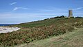
War trophies of four German 13.5 cm K 09 artillery guns were displayed next to Victoria Tower until two were scrapped in 1938 and in 1940 the remaining two were buried in case enemy aircraft suspected they were "live". Forgotten about, they were uncovered in 1978 and are again on display. [34]

World War II

The island was demilitarised in June 1940 including suspending the militia again. During the German occupation which ran from June 1940 to May 1945 a massive building programme was instigated by Germany which saw the construction of tunnels, anti-tank sea walls, coastal casemates, artillery positions, artillery observation towers, radar units and a mass of trenches, minefields and barbed wire entanglements.

Up to 7,000 Organisation Todt workers in Guernsey built mainly in two years, between 1941 and 1943, the bulk of the fortifications. The German Festung Guernsey book recorded 616,000m³ of concrete used in Guernsey, [35] almost 10% of the concrete used in the Atlantic Wall.

Of the eleven artillery batteries on Guernsey, the largest was located in Batterie Mirus, comprising four 30.5 cm guns which had a range of 51 kilometres (32 mi). [36]

Camouflage was used in defensive works by German engineers, as were burying or part burying structures to escape aerial observation and attack. Many guns were designed to fire at an angle across a potential danger area rather than facing the sea, where they would be susceptible to direct fire from ships. The thickness of the concrete walls and roofs of the German structures providing adequate protection for weapons developed by 1944.

Many constructions are on private land and not accessible to the public, others may be looked at, clambered over and a few can be entered with care. Those that can be visited include:

ParishPlace/NameNotesCoordinates
St Peter Port Castle Cornet ‡ £Hafenschloss ("Harbour Castle") now a museum 49°27′10.8″N2°32′15.7″W / 49.453000°N 2.537694°W / 49.453000; -2.537694 ("Castle Cornet")
St Peter PortSt Jacques ‡ £Naval Signals HQ, now a museum [37] 49°27′39.8″N2°32′46.7″W / 49.461056°N 2.546306°W / 49.461056; -2.546306 (" Naval Signals HQ")
St Peter PortLa Vallette tunnels £Tunnels used to store fuel, now a museum 49°26′53.7″N2°31′52.9″W / 49.448250°N 2.531361°W / 49.448250; -2.531361 ("La Vallette")
St Andrew"Ho.7/40" tunnels £ [38] Large tunnel complex, now the underground hospital museum 49°26′31.8″N2°34′35.2″W / 49.442167°N 2.576444°W / 49.442167; -2.576444 ("German Underground Hospital")
ForestGerman Occupation Museum £Main island museum relating to the occupation period 49°25′46″N2°35′35.4″W / 49.42944°N 2.593167°W / 49.42944; -2.593167 ("German Occupation Museum")
Torteval"Battery Dollmann" ʘRestored German 22 cm battery 49°25′37.6″N2°40′3.9″W / 49.427111°N 2.667750°W / 49.427111; -2.667750 ("Battery Dollmann")
Torteval"Observation Tower MP3" £Artillery observation tower now a museum 49°25′57.3″N2°40′17.2″W / 49.432583°N 2.671444°W / 49.432583; -2.671444 ("Battery Dollmann")
St PeterL’Eree headland trenches ʘre-excavated trench system 49°27′27.3″N2°39′22.8″W / 49.457583°N 2.656333°W / 49.457583; -2.656333 ("L’Eree headland")
Castel Fort Hommet 10.5cm Casement ‡ £Renovated beach defence area now a museum 49°28′24.2″N2°36′33.7″W / 49.473389°N 2.609361°W / 49.473389; -2.609361 ("Fort Hommet 10.5cm casement")
ValeL’Ancresse ʘAssorted bunkers on the common and nearby anti tank wall 49°30′13″N2°31′7.7″W / 49.50361°N 2.518806°W / 49.50361; -2.518806 ("L’Ancresse")
ValeVale Castle ‡ ʘGerman modifications to older castle 49°29′6.5″N2°30′32.9″W / 49.485139°N 2.509139°W / 49.485139; -2.509139 ("Vale castle")

Key ‡ Protected Monument [11] £ Accessible with fee ʘ Accessible

Cold War

Castle Cornet provided an underground control bunker, using the WW2 German concrete construction, which would, in the event of war, control shipping in the western end of the English Channel. [39]

See also

Related Research Articles

<span class="mw-page-title-main">History of Guernsey</span>

The history of Guernsey stretches back with evidence of Neolithic occupation, followed by Roman occupation. Christianity was brought to Guernsey by St Sampson.

<span class="mw-page-title-main">Atlantic Wall</span> Extensive system of coastal fortifications built by Nazi Germany

The Atlantic Wall was an extensive system of coastal defences and fortifications built by Nazi Germany between 1942 and 1944 along the coast of continental Europe and Scandinavia as a defence against an anticipated Allied invasion of Nazi-occupied Europe from the United Kingdom, during World War II. The manning and operation of the Atlantic Wall was administratively overseen by the German Army, with some support from Luftwaffe ground forces. The Kriegsmarine maintained a separate coastal defence network, organised into a number of sea defence zones.

<span class="mw-page-title-main">Fort Grey</span>

Fort Grey, colloquially known as the "cup and saucer", is a Martello tower located on a tidal rock in Rocquaine Bay in Saint Peter, Guernsey on the west coast of the island.

<span class="mw-page-title-main">Castle Cornet</span> Island castle in Guernsey

Castle Cornet is a large island castle in Guernsey, and former tidal island, also known as Cornet Rock or Castle Rock. Its importance was as a defence not only of the island, but of the roadstead. In 1859 it became part of one of the breakwaters of Guernsey's main harbour, St Peter Port harbour.

<span class="mw-page-title-main">Fort George, Guernsey</span>

Fort George is situated in Saint Peter Port, Guernsey, and was built to become the main island military headquarters and to protect barracks to house the island garrison for the British Army, in place of Castle Cornet.

<span class="mw-page-title-main">Fort Hommet 10.5 cm coastal defence gun casemate bunker</span> WWII Nazi Germany bunker on Guernsey

The Fort Hommet 10.5 cm coastal defence gun casemate bunker is a fully restored gun casemate that was part of Fortress Guernsey constructed by the forces of Nazi Germany between 1940 and 1945.

<span class="mw-page-title-main">Victoria Tower, Guernsey</span> Tower in Guernsey, Channel Islands

Victoria Tower is a monument in Saint Peter Port, Guernsey, erected in honor of a visit by Queen Victoria and Prince Albert to the island in 1846.

<span class="mw-page-title-main">Coastal defence and fortification</span> Measures to protect against a military attack by a coastline

Coastal defenceand coastal fortification are measures taken to provide protection against military attack at or near a coastline, for example, fortifications and coastal artillery. Because an invading enemy normally requires a port or harbour to sustain operations, such defences are usually concentrated around such facilities, or places where such facilities could be constructed. Coastal artillery fortifications generally followed the development of land fortifications, usually incorporating land defences; sometimes separate land defence forts were built to protect coastal forts. Through the middle 19th century, coastal forts could be bastion forts, star forts, polygonal forts, or sea forts, the first three types often with detached gun batteries called "water batteries". Coastal defence weapons throughout history were heavy naval guns or weapons based on them, often supplemented by lighter weapons. In the late 19th century separate batteries of coastal artillery replaced forts in some countries; in some areas these became widely separated geographically through the mid-20th century as weapon ranges increased. The amount of landward defence provided began to vary by country from the late 19th century; by 1900 new US forts almost totally neglected these defences. Booms were also usually part of a protected harbor's defences. In the middle 19th century underwater minefields and later controlled mines were often used, or stored in peacetime to be available in wartime. With the rise of the submarine threat at the beginning of the 20th century, anti-submarine nets were used extensively, usually added to boom defences, with major warships often being equipped with them through early World War I. In World War I railway artillery emerged and soon became part of coastal artillery in some countries; with railway artillery in coast defence some type of revolving mount had to be provided to allow tracking of fast-moving targets.

<span class="mw-page-title-main">Sir John Doyle, 1st Baronet</span> British Army general (1756–1834)

General Sir John Doyle, 1st Baronet GCB, KCH was a British Army officer, who served with distinction in the American War of Independence and the French Revolutionary Wars.

<span class="mw-page-title-main">Jerbourg Point</span>

Jerbourg Point or the Jerbourg Peninsula is the southeastern point of the Bailiwick of Guernsey in the English Channel off the coast of Normandy, lying within St Martin Parish. It marks the end of the east coast cliffs and beginning of the south coast cliffs. It provides scenic views of the Little Russel and the various islands.

<span class="mw-page-title-main">Bréhon Tower</span> 19th-century Guernsey gun tower

The Bréhon Tower is accessible only by boat and sits on Bréhon Rock, an island in the Little Russell channel about 1.5 km northeast of St Peter Port, Guernsey, between the port and the islands of Herm and Jethou. Thomas Charles de Putron (1806–1869) built the oval tower of granite from Herm, completing the work in 1857.

<span class="mw-page-title-main">Fort Saumarez</span>

Fort Saumarez is a Martello tower in Saint Peter, Guernsey, on a headland that forms the northern tip of L'Erée and extends to the Lihou causeway.

<span class="mw-page-title-main">Fort Hommet</span>

Fort Hommet is a fortification on Vazon Bay headland in Castel, Guernsey. It is built on the site of fortifications that date back to 1680 and consists of a Martello tower from 1804, later additions during the Victorian Era, and bunkers and casemates that the Germans constructed during World War II.

<span class="mw-page-title-main">Guernsey loophole towers</span>

The British built 15 Guernsey loophole towers at various points along the coast of Guernsey between August 1778 and March 1779 to deter possible French attacks after France had declared itself an ally of the Americans in the American Revolutionary War. Towards the start of the Napoleonic Wars several towers received additional reinforcement in the form of batteries at their bases. Today, 12 towers still survive, three having been destroyed at different times. Two of the survivors, Petit Bôt and Rousse, contain interpretive exhibits that the public may examine.

<span class="mw-page-title-main">Royal Guernsey Militia</span> Military unit

The Royal Guernsey Militia has a history dating back 800 years. Always loyal to the British Crown, the men were unpaid volunteers whose wish was to defend the Island of Guernsey from foreign invaders.

<span class="mw-page-title-main">German fortification of Guernsey</span> Aspect of the German occupation of Guernsey

After the Wehrmacht occupied the Channel Islands on 30 June 1940, they assessed the existing defences to determine if they would be of use. The Germans found the Islands' fortifications antiquated and woefully inadequate for modern warfare.

<span class="mw-page-title-main">Fortifications of Alderney</span>

Apart from a Roman Fort, there were very few fortifications in Alderney until the mid 19th century. These were then modified and updated in the mid 20th Century by Germans during the occupation period. Alderney at 8 km2 is now one of the most fortified places in the world.

<span class="mw-page-title-main">Archaeology of the Channel Islands</span>

Archaeology is promoted in Jersey by the Société Jersiaise and by Jersey Heritage. Promotion in the Bailiwick of Guernsey being undertaken by La Société Guernesiaise, Guernsey Museums, the Alderney Society with World War II work also undertaken by Festung Guernsey.

<span class="mw-page-title-main">Vale Castle, Guernsey</span>

Vale Castle, is a protected building located in the Vale, Guernsey. The original name was "Le Château St Michel", later it became "Château de Val" or "Château de Valle" and is over 1,000 years old. It defends both St. Sampson's harbour at the eastern end of the Braye du Valle, Guernsey, and Bordeaux Harbour.

The Batterie Mirus is located in Saint Peter and Saint Saviour, Guernsey. Originally called Batterie Nina, it comprised four 30.5 cm guns. The battery was constructed from November 1941 and through the first half of 1942, and was the largest battery in the Channel Islands, the guns having a maximum range of 51 km. Although the guns were removed in the early 1950s, the reinforced concrete structures and associated positions remain intact.

References

  1. 1 2 3 4 Sebire, Heather. The Archaeology and Early history of the Channel Islands. NPI Media Group. ISBN   978-0752434490.
  2. "Chateau des Marais". BBC. 24 September 2014.
  3. Berry, William. The history of Guernsey from the remotest period of antiquity to the year 1814.
  4. 1 2 Lempriére, Raoul. History of the Channel Islands. Robert Hale Ltd. p. 33. ISBN   978-0709142522.
  5. The Guernsey and Jersey Magazine, Volumes 1–2. 1836. p. 169.
  6. Marr, James. Bailiwick Bastions. Guernsey Press. ISBN   0 902550 11X.
  7. 1 2 "The Legge Report, or King's Survey of the Channel Islands, 1680". Priaulx Library.
  8. "ST PETER PORT TOWN DEFENCES". Gatehouse.
  9. 1 2 "Pezeries". The Sarnian.
  10. 1 2 "History of the Vale Castle". BBC. 13 November 2014.
  11. 1 2 3 4 "Protected Monuments". Guernsey government.
  12. "Towers". Guernsey Museum.
  13. Crossan, Rose-Marie (2015). Poverty and Welfare in Guernsey, 1560–2015. Boydell Press. ISBN   978-1783270408.
  14. 1 2 Cox, Gregory Stevens (July 1989). Guernsey & the French Revolution. Guille Alles Library.
  15. Hocart, Richard (1977). Peter de Havilland: Bailiff of Guernsey : a history of his life, 1747–1821. Société Guernesiaise.
  16. "General Sir John Doyle". BBC. 24 March 2009.
  17. Biographical Sketch of the Honourable Lieutenant-General Sir John Doyle. T Greenslade, Guernsey. 1 November 1806.
  18. 1 2 Lempriére, Raoul. History of the Channel Islands. Robert Hale Ltd. p. 130. ISBN   978-0709142522.
  19. 1 2 3 4 5 6 7 8 9 10 11 12 13 14 15 16 17 18 19 "Gun Batteries". Guernsey Museums.
  20. "Fermain Tower Accommodation Plans Revealed". Island FM. 28 April 2017.[ permanent dead link ]
  21. "Saints tower No 14". Guernsey museum.
  22. "Petit Bôt tower No 13". Guernsey museum.
  23. 1 2 3 4 5 6 "Forts". Guernsey museum.
  24. "Mont Chinchon". BBC. 13 November 2014.
  25. "Vazon tower No 12". Guernsey museum.
  26. "Watchhouses". Guernsey museum.
  27. "Magazines". Guernsey museum.
  28. "Rousse tower No 11". Guernsey museum.
  29. "Chouet tower No 10". Guernsey museum.
  30. 1 2 Toms, Carel (2003). St Peter Port, People & Places. ISBN   1 86077 258 7.
  31. 1 2 Girard, Peter (1990). More of Peter Girard's Guernsey: A Second Miscellany of Guernsey's History and Its People. Guernsey Press. ISBN   978-0902550421.
  32. Ogier, Darryl. The Government and Law of Guernsey. States of Guernsey. p. 212. ISBN   978-0-9549775-1-1.
  33. "WW1 submarine hunters: French seaplane base in Guernsey". BBC. 6 August 2014.
  34. "The Guernsey Guns" (PDF). Great War CI.
  35. "History:Fortifying Guernsey". Festung Guernsey. Archived from the original on 9 April 2016.
  36. "Batterie Mirus". Festung Guernsey. Archived from the original on 7 March 2016. Retrieved 12 August 2016.
  37. "St Jacques Naval Headquarters". CIOS. Archived from the original on 3 May 2013. Retrieved 12 August 2016.
  38. "German Military Underground Hospital". BBC. 24 September 2014.
  39. "Guernsey Castle Cornet Cold War rooms opened to public". BBc. 1 April 2016.