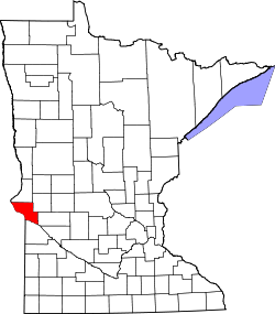
Foster, Minnesota | |
---|---|
Unincorporated community | |
Coordinates: 45°24′59″N96°40′33″W / 45.41639°N 96.67583°W Coordinates: 45°24′59″N96°40′33″W / 45.41639°N 96.67583°W | |
Country | United States |
State | Minnesota |
County | Big Stone |
Elevation | 997 ft (304 m) |
Time zone | Central (CST) (UTC-6) |
• Summer (DST) | CDT (UTC-5) |
Area code(s) | 320 |
GNIS feature ID | 643834 [1] |
Foster is an unincorporated community in Foster Township, Big Stone, Minnesota, United States. [1]
Foster Township is a township in Big Stone County, Minnesota, United States. The population was 123 as of the 2000 census.
Big Stone County is a county in the U.S. state of Minnesota. As of the 2010 United States Census, the population was 5,269. Its county seat is Ortonville.
Minnesota is a state in the Upper Midwest and northern regions of the United States. Minnesota was admitted as the 32nd U.S. state on May 11, 1858, created from the eastern half of the Minnesota Territory. The state has a large number of lakes, and is known by the slogan the "Land of 10,000 Lakes". Its official motto is L'Étoile du Nord.
Foster was platted in 1880. It was named for Foster L. Balch. [2]
In the United States, a plat is a map, drawn to scale, showing the divisions of a piece of land. United States General Land Office surveyors drafted township plats of Public Lands Surveys to show the distance and bearing between section corners, sometimes including topographic or vegetation information. City, town or village plats show subdivisions into blocks with streets and alleys. Further refinement often splits blocks into individual lots, usually for the purpose of selling the described lots; this has become known as subdivision.
This article about a location in Big Stone County, Minnesota is a stub. You can help Wikipedia by expanding it. |
Faribault County is a county in the U.S. state of Minnesota. As of the 2010 United States Census, the population was 14,553. Its county seat is Blue Earth.
Browns Valley Township is a township in Big Stone County, Minnesota, United States. The population was 438 as of the 2000 census.
Prior Township is a township in Big Stone County, Minnesota, United States. The population was 223 as of the 2000 census.
Toqua Township is a township in Big Stone County, Minnesota, United States. The population was 87 as of the 2000 census.
Foster Township is a township in Faribault County, Minnesota, United States. The population was 314 at the 2000 census.
Rollins is an unincorporated community in Ault Township, Saint Louis County, Minnesota, United States.
Minnesota Glacier is a broad glacier, about 40 nautical miles long and 5 nautical miles wide, flowing east through the Ellsworth Mountains in Antarctica, separating the Sentinel Range and the Heritage Range. It is nourished by ice from the plateau west of the mountains and by Nimitz Glacier and Splettstoesser Glacier, and merges into the larger Rutford Ice Stream at the eastern margin of the Ellsworth Mountains.
San Francisco is an abandoned townsite in San Francisco Township in Carver County, Minnesota, United States.
Fairbanks is an unincorporated community in Fairbanks Township, Saint Louis County, Minnesota, United States; located within the Superior National Forest.
Kelsey is an unincorporated community in Kelsey Township, Saint Louis County, Minnesota, United States.
Skibo is an unincorporated community in Bassett Township, Saint Louis County, Minnesota, United States.
Keenan is an unincorporated community in Clinton Township, Saint Louis County, Minnesota, United States.
Robinson is an unincorporated community in Morse Township, Saint Louis County, Minnesota, United States.
Soudan is an unincorporated community and census-designated place (CDP) in Breitung Township, Saint Louis County, Minnesota, United States. As of the 2010 census, its population was 446.
Sandy Lake is an unincorporated community Native American village located in Turner Township, Aitkin County, Minnesota, United States. Its name in the Ojibwe language is Gaa-mitaawangaagamaag, meaning "Place of the Sandy-shored Lake". The village is administrative center for the Sandy Lake Band of Mississippi Chippewa, though the administration of the Mille Lacs Indian Reservation, District II, is located in the nearby East Lake.
Gopher Glacier is a glacier descending from Christoffersen Heights and draining north between Bonnabeau Dome and Anderson Dome, in the Jones Mountains of Antarctica. It was mapped and named by the University of Minnesota Jones Mountains Party, 1960–61; "Gopher" is the nickname of the University of Minnesota and of the State.
Wahlsten is an unincorporated community in Kugler Township, Saint Louis County, Minnesota, United States.
Yankeetown is an unincorporated community in Foster Township, Big Stone County, Minnesota, United States.
Bonanza Grove is an unincorporated community in Foster Township, Big Stone County, Minnesota, United States.