Freemanville, Alabama | |
|---|---|
 Freemanville  Freemanville | |
| Coordinates: 31°04′19″N87°31′15″W / 31.07194°N 87.52083°W | |
| Country | United States |
| State | Alabama |
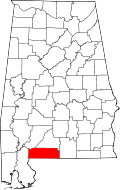
| County | Escambia |
| Elevation | 289 ft (88 m) |
| Time zone | UTC-6 (Central (CST)) |
| • Summer (DST) | UTC-5 (CDT) |
| Area code | 251 |
| GNIS feature ID | 118629 [1] |
Freemanville is an unincorporated community in Escambia County, Alabama, United States, near Atmore.
A post office operated in Freemanville from 1908 to 1955. [2]