Related Research Articles

The Central Valley is a broad, flat valley that dominates the interior of California. It is 40 to 60 miles wide and stretches approximately 450 miles (720 km) from north-northwest to south-southeast, inland from and parallel with the Pacific coast. It covers approximately 18,000 square miles (47,000 km2), about 11% of California's land area. The valley is bounded by the Coast Ranges to the west and the Sierra Nevada to the east.

Tulare Lake is a freshwater dry lake with residual wetlands and marshes in the southern San Joaquin Valley, California, United States. After Lake Cahuilla disappeared in the 17th century, Tulare Lake was the largest freshwater lake west of the Mississippi River and the second-largest freshwater lake entirely in the United States, based upon surface area. A remnant of Pleistocene-era Lake Corcoran, Tulare Lake dried up after its tributary rivers were diverted for agricultural irrigation and municipal water uses.

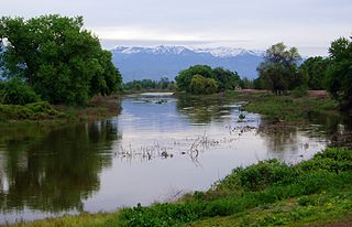
The San Joaquin River is the longest river of Central California. The 366-mile (589 km) long river starts in the high Sierra Nevada, and flows through the rich agricultural region of the northern San Joaquin Valley before reaching Suisun Bay, San Francisco Bay, and the Pacific Ocean. An important source of irrigation water as well as a wildlife corridor, the San Joaquin is among the most heavily dammed and diverted of California's rivers.

The Kings River is a 132.9-mile (213.9 km) river draining the Sierra Nevada mountain range in central California in the United States. Its headwaters originate along the Sierra Crest in and around Kings Canyon National Park and form the eponymous Kings Canyon, one of the deepest river gorges in North America. The river is impounded in Pine Flat Lake before flowing into the San Joaquin Valley southeast of Fresno. With its upper and middle course in Fresno County, the Kings River diverges into multiple branches in Kings County, with some water flowing south to the old Tulare Lake bed and the rest flowing north to the San Joaquin River. However, most of the water is consumed for irrigation well upstream of either point.

The Merced River, in the central part of the U.S. state of California, is a 145-mile (233 km)-long tributary of the San Joaquin River flowing from the Sierra Nevada into the San Joaquin Valley. It is most well known for its swift and steep course through the southern part of Yosemite National Park, where it is the primary watercourse flowing through Yosemite Valley. The river's character changes dramatically once it reaches the plains of the agricultural San Joaquin Valley, where it becomes a slow-moving meandering stream.
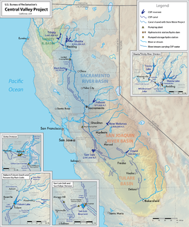
The Central Valley Project (CVP) is a federal power and water management project in the U.S. state of California under the supervision of the United States Bureau of Reclamation (USBR). It was devised in 1933 in order to provide irrigation and municipal water to much of California's Central Valley—by regulating and storing water in reservoirs in the northern half of the state, and transporting it to the water-poor San Joaquin Valley and its surroundings by means of a series of canals, aqueducts and pump plants, some shared with the California State Water Project (SWP). Many CVP water users are represented by the Central Valley Project Water Association.
The St. John's River is a distributary of the Kaweah River in the San Joaquin Valley of California in the United States. The river begins at a diversion dam at McKay's Point, about a mile west of Lemon Cove. The distributary flows west along the north side of the city of Visalia, where it joins Elbow Creek, continuing west to Cross Creek.

The Kern River, originally Rio de San Felipe, later La Porciuncula, is a river in the U.S. state of California, approximately 165 miles (270 km) long. It drains an area of the southern Sierra Nevada mountains northeast of Bakersfield. Fed by snowmelt near Mount Whitney, the river passes through scenic canyons in the mountains and is a popular destination for whitewater rafting and kayaking. It is the southernmost major river system in the Sierra Nevada, and is the only major river in the Sierra that drains in a southerly direction.
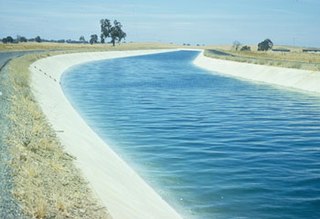
The Delta–Mendota Canal is a 117-mile-long (188 km) aqueduct in central California, United States. The canal was designed and completed in 1951 by the U.S. Bureau of Reclamation as part of the Central Valley Project to supply freshwater to users downstream of the San Joaquin River. Freshwater is diverted into the Madera Canal and Friant-Kern Canal at Friant Dam.

Friant Dam is a concrete gravity dam on the San Joaquin River in central California in the United States, on the boundary of Fresno and Madera Counties. It was built between 1937 and 1942 as part of a U.S. Bureau of Reclamation (USBR) water project to provide irrigation water to the southern San Joaquin Valley. The dam impounds Millerton Lake, a 4,900-acre (2,000 ha) reservoir about 15 miles (24 km) north of Fresno.

Pine Flat Dam is a concrete gravity dam on the Kings River in the Central Valley of Fresno County, California United States. Situated about 28 miles (45 km) east of Fresno, the dam is 440 feet (130 m) high and impounds Pine Flat Lake, one of the largest reservoirs in California, in the foothills of the Sierra Nevada just outside the boundary of Kings Canyon National Park. The dam's primary purpose is flood control, with irrigation, hydroelectric power generation and recreation secondary in importance.

San Luis Dam is a major earth-filled dam in Merced County, California, which forms San Luis Reservoir, the largest off-stream reservoir in the United States. The dam and reservoir are located in the Diablo Range to the east of Pacheco Pass and about 10 miles (16 km) west of Los Banos. San Luis Dam, a jointly-owned state and federal facility, stores more than 2 million acre feet (2.5 km3) of water for the California State Water Project and the federal Central Valley Project. Although the dam is located in the valley of San Luis Creek, the majority of its water comes from man-made aqueducts which are supplied from other rivers in Northern California.

Millerton Lake is an artificial lake near the town of Friant about 15 mi (24 km) north of downtown Fresno. The reservoir was created by the construction of 319 ft high Friant Dam on the San Joaquin River which, with the lake, serves as much of the county line between Fresno County to the south and Madera County to the north.

The Fresno River is a river in Central California and a major tributary of the San Joaquin River. It runs approximately 68 miles (109 km) from the Sierra Nevada Range to the San Joaquin River. Although called the 'Fresno' River, it is one of the largest and longest river systems in Madera County.

The Friant-Kern Canal is a 152 mi (245 km) aqueduct managed by the United States Bureau of Reclamation in Central California to convey water to augment irrigation capacity in Fresno, Tulare, and Kern counties. A part of the Central Valley Project, canal construction began in 1949 and was completed in 1951 at a cost of $60.8 million.
Pueblo de las Juntas is a former settlement in Fresno County, California situated at the confluence of the San Joaquin River and Fresno Slough, 2 miles (3.2 km) north of Mendota.

Watson's Ferry was a former settlement, river ferry and steamboat landing on Fresno Slough near its confluence with the San Joaquin River nearby to the northeast of modern Mendota in what is now Fresno County, California. Watson's Ferry was located 8 miles southeast of Firebaugh.
Whites Bridge or Whitesbridge is a former settlement on the Fresno Slough near Tranquillity in Fresno County, California.
The Delta Cross Channel is a facility in California's Sacramento-San Joaquin Delta that diverts water from the Sacramento River. The facility was built in 1951 in Walnut Grove, California.

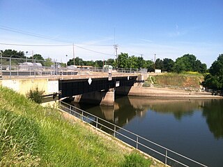
The C.W. Bill Jones Pumping Plant located 9 miles northwest of Tracy, CA, was constructed between 1947 and 1951, and is a key component of the Central Valley Project. The Delta Cross Channel intercepts Sacramento River water as it travels westwards towards Suisun Bay and diverts it south through a series of man-made channels, the Mokelumne River, and other natural sloughs, marshes and distributaries. From there, the water travels to the C.W. Bill Jones Pumping Plant, which raises water into the Delta-Mendota Canal, which in turn travels 117 miles (188 km) southwards to Mendota Pool on the San Joaquin River, supplying water to other CVP reservoirs about midway. The Tracy Fish Collection Facility exists at the entrance of the pump plant in order to catch fish that would otherwise end up in the Delta-Mendota Canal.
References
- ↑ Mendota Dam, the Delta-Mendota Canal, and Mendota Pool from www.revivethesanjoaquin.org accessed November 7, 2011.