
Winnebago County is a county in the U.S. state of Wisconsin. As of the 2010 census, the population was 166,994. Its county seat is Oshkosh. It was named for the historic Winnebago people, a federally recognized Native American tribe now known as the Ho-Chunk Nation. Chief Oshkosh was a leader in the area. Winnebago County comprises the Oshkosh-Neenah, WI Metropolitan Statistical Area, which is included in the Appleton-Oshkosh-Neenah, WI Combined Statistical Area.

The Fox River is a river in eastern Wisconsin in the Great Lakes region of the United States. It is the principal tributary of the Bay of Green Bay, and via the Bay, the largest tributary of Lake Michigan. The well-known city of Green Bay, one of the first European settlements in North America, is on the river at its mouth on lower Green Bay.
U.S. Highway 151 (US 151) is a United States Numbered Highway that runs through the states of Iowa and Wisconsin. The southern terminus for US 151 is at a junction with Interstate 80 (I-80) in Iowa County, Iowa, and its northern terminus is at Manitowoc, Wisconsin. The route, from south to north follows a northeasterly path through the two states.
The Fox Cities of Northeastern Wisconsin are the cities, towns and villages along the Fox River as it flows from Lake Winnebago northward into Green Bay.

Withlacoochee State Trail is a 46-mile (74 km) long paved, multi-use, non-motorized rail trail in Florida located in Citrus, Hernando and Pasco counties. It follows along the Withlacoochee River and passes through the Withlacoochee State Forest. It is the longest paved rail trail in Florida.
State Trunk Highway 21 is a state highway in the U.S. state of Wisconsin. It runs east–west across the center of the state between Sparta and Oshkosh. The route often serves as a direct route for travelers between Appleton and Oshkosh to Tomah and La Crosse. It is a two-lane surface road for nearly all of its length, with the exception of a few urban arterials of four or more lanes. The section of WIS 21 between Fort McCoy and I-94 in Tomah is classified as a "Major STRAHNET Connector." while the route past I-94 is classified as a "Non-Interstate STRAHNET Route"
State Trunk Highway 42 is a state highway in the U.S. state of Wisconsin. It runs for about 138 miles (222 km) north–south in northeast Wisconsin from Sheboygan to the ferry dock in Northport. Much of the highway is part of the Lake Michigan Circle Tour from the eastern junction with U.S. Highway 10 (US 10) in Manitowoc to its junction with WIS 57 in Sister Bay. WIS 42 parallels I-43 from Sheboygan to Manitowoc, and parallels WIS 57 throughout much of the route, particularly from Manitowoc to Sturgeon Bay, meeting the northern terminus of WIS 57 in Sister Bay.
State Trunk Highway 164 is a Wisconsin state highway running from Slinger, around the city of Waukesha, to Waterford.
State Trunk Highway 71 is a 53.55-mile (86.18 km) state highway in Jackson, Monroe, and Juneau counties in the southwestern area of the US state of Wisconsin that runs in a southeast-northwest direction from the Village of Melrose to Elroy.
State Trunk Highway 114 is a state highway in the U.S. state of Wisconsin. It runs east–west in east central Wisconsin from Neenah to Hilbert. The highway ran from Neenah to Brillion before about 1986, when the section from Hilbert to Brillion was turned back to Calumet County, which now maintains it as County Trunk Highway PP (CTH-PP).
State Trunk Highway 129 is a 2.69-mile (4.33 km) state highway in central Grant County, Wisconsin, United States, that runs from U.S. Route 61/Wisconsin Highway 35/Wisconsin Highway 81 (US 61/WIS 35/WIS 81) southeast of the city of Lancaster north to US 61 northeast of the city of Lancaster, bypassing the city to the east. WIS 129 is maintained by the Wisconsin Department of Transportation.
State Trunk Highway 150 was a state highway in the U.S. state of Wisconsin. It ran east–west between Winchester and Neenah. In 2003, the road was turned over to Winnebago County, which now maintains it as County Trunk Highway II (CTH-II).
State Trunk Highway 180 is a 30.42-mile (48.96 km), north–south state highway in southeastern Marinette County, Wisconsin, United States, that runs from Wisconsin Highway 64 (WIS 64) in Marinette to U.S. Route 141 (US 141) in Wausaukee.
State Trunk Highway 310 is a state highway in the U.S. state of Wisconsin. It runs east–west in east-central Wisconsin from near Manitowoc to Two Rivers. The nearly nine-mile-long (14 km) road passes through mainly rural areas and intersects multiple County Highways along the way. The route came about in 1984 when US Highway 10 was rerouted southbound with Interstate 43 (I-43) and County Trunk Highway D (CHT-D) fell into state control. It is also one of two state trunk highways connecting I-43 with WIS 42; the other is WIS 147.

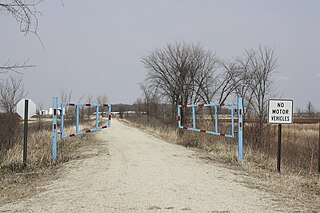
The Wiouwash State Trail is a rail trail in northeastern Wisconsin. Its name is derived from the first two letters of the four counties it traverses: Winnebago, Outagamie, Waupaca, and Shawano. The trail's Tribal Heritage Crossing of Lake Butte des Morts is a nationally designated recreation trail. The trail is used by walkers, hikers, bikers, horseback riders, and snowmobilers during the winter months. Two sections of the trail are complete: 24 miles from Aniwa south to Split Rock and 21 miles from Hortonville south to Oshkosh.
The Fox River State Recreational Trail is a trail along the Fox River in northeastern Wisconsin.
Mascoutin Valley State Trail is a rail trail in northeastern Wisconsin. The trail is used for walking, bicycling, horseback riding, and snowmobiling during the winter months. The trail can also be used for cross-country skiing and snowshoeing but the trail is not groomed and must be shared with snowmobiles. Numerous miles of snowmobile trails connect to the Mascoutin Valley State Trail.

The Natchaug Trail is a Blue-Blazed hiking trail "system" which meanders through 19.5 miles (31.4 km) of forests in northeast Connecticut—primarily in Windham County. It is maintained by the Connecticut Forest and Park Association. Its southern trailhead begins in the James L. Goodwin State Forest in the towns of Chaplin, Connecticut and Hampton, Connecticut and the northern terminus is at its intersection with the Nipmuck Trail in Natchaug State Forest in Eastford, Connecticut.

Fox Crossing is a village in Winnebago County, Wisconsin, United States. It was incorporated from the former Town of Menasha in 2016. The estimated population in 2018 was 19,029.

The Mountain-Bay State Trail is an 83-mile state-designated rail trail in Brown, Marathon, and Shawano Counties in Wisconsin. The trail is the longest rail trail in the state.

