Waupaca County is a county in the U.S. state of Wisconsin. As of the 2020 census, the population was 51,812. The county seat is Waupaca. The county was created in 1851 and organized in 1853. It is named after the Waupaca River, a Menominee language name meaning 'white sand bottom', 'pale water', or 'tomorrow river'.

Shawano County is a county located in the U.S. state of Wisconsin. As of the 2020 census, the population was 40,881. Its county seat is Shawano.

Oconto County is a county in the U.S. state of Wisconsin. As of the 2020 census, the population was 38,965. Its county seat is Oconto. The county was established in 1851.

Menominee County is a county in the U.S. state of Wisconsin. As of the 2020 census, the population was 4,255, making it the least populous county in Wisconsin. Its county seat is in the community of Keshena.

Marathon County is a county located in the U.S. state of Wisconsin. As of the 2020 census, the population was 138,013. Its county seat is Wausau. It was founded in 1850, created from a portion of Portage County. At that time the county stretched to the northern border with the upper Michigan peninsula. It is named after the battlefield at Marathon, Greece.

Langlade County is a county located in the U.S. state of Wisconsin. As of the 2020 census, the population was 19,491. Its county seat is Antigo.

Brown County is a county in the U.S. state of Wisconsin. As of the 2020 census, the population was 268,740, making it the fourth-most populous county in Wisconsin. The county seat is Green Bay. Brown County is part of the Green Bay, WI Metropolitan Statistical Area.

Shawano is a city and the county seat of Shawano County, Wisconsin, United States. The population was 9,243 at the 2020 census.

Pulaski is a village in Brown, Oconto, and Shawano counties in the U.S. state of Wisconsin. The population was 3,539 at the 2010 census. Of this, 3,321 were in Brown County, 218 in Shawano County, and none in Oconto County.

Birnamwood is a village in Marathon and Shawano counties in the U.S. state of Wisconsin. It is part of the Wausau, Wisconsin Metropolitan Statistical Area. The population was 818 at the 2010 census. Of this, 802 were in Shawano County, and 16 were in Marathon County. The village is located mostly within the town of Birnamwood in Shawano County; only a small portion extends into the town of Norrie in adjacent Marathon County.

Green Bay is a town in Brown County in the U.S. state of Wisconsin. The population was 2,035 at the 2010 census. The town is located several miles northeast of the city of Green Bay. The unincorporated community of Champion is located in the town, and the unincorporated communities of Dyckesville and New Franken are located partially in the town.

State Trunk Highway 29 is a state highway running east–west across central Wisconsin. It is a major east–west corridor connecting the Twin Cities and the Chippewa Valley with Wausau and Green Bay. A multi-year project to convert the corridor to a four-lane freeway or expressway from Elk Mound to Green Bay was completed in 2005. The remainder of WIS 29 is two-lane surface road or an urban multi-lane road.
Briarton is an unincorporated community in Shawano County, Wisconsin, United States, in the Town of Lessor, west of Green Bay.

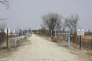
The Wiouwash State Trail is a rail trail in northeastern Wisconsin. Its name is derived from the first two letters of the four counties it traverses: Winnebago, Outagamie, Waupaca, and Shawano. The trail's Tribal Heritage Crossing of Lake Butte des Morts is a nationally designated recreation trail. The trail is used by walkers, hikers, bikers, horseback riders, and snowmobilers during the winter months. Two sections of the trail are complete: 24 miles from Aniwa south to Split Rock and 21 miles from Hortonville south to Oshkosh.

The Fox River State Recreational Trail is a trail along the Fox River in northeastern Wisconsin.

There are a variety of schema for dividing Wisconsin into regions.

The Ahnapee State Trail is a multi-use trail along the Ahnapee River and the Kewaunee River in northeastern Wisconsin.

The Duck Creek Trail is a crushed limestone trail in Outagamie and Brown Counties in northeast Wisconsin. The Duck Creek Trail spans seven miles (11 km), beginning at the eastern end of the Newton Blackmour State Trail, just east of Vanderheuvel Road in Seymour. The trail continues east through the Oneida Nation of Wisconsin in northern Outagamie County paralleling State Route 54, and continues to the Village of Oneida. The Duck Creek Trail will eventually extend to Pamperin Park in Green Bay.
The White River State Trail is a 19-mile state designated rail trail in Racine and Walworth Counties in Wisconsin.

The Friendship Trail is a recreation trail in northeastern Wisconsin. The trail is used by walkers, hikers, bikers, horseback riders, and snowmobilers during the winter months. Two sections of the trail are complete: ~14 miles from Winchester east to Fox Crossing and ~4.4 miles from Forest Junction southeast to Brillion. The route consists of asphalt, crushed stone, and wood surfaces. The entire route is located in Winnebago County and Calumet County.


