This article needs additional citations for verification .(November 2023) |

The Fox River State Recreational Trail (also known as the Fox River Trail) is a trail along the Fox River in northeastern Wisconsin.
This article needs additional citations for verification .(November 2023) |
The Fox River State Recreational Trail (also known as the Fox River Trail) is a trail along the Fox River in northeastern Wisconsin.

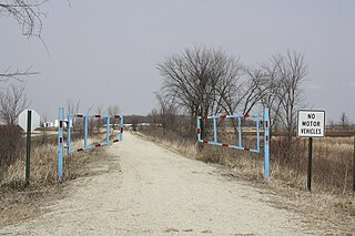
The trail begins at the CityDeck in Green Bay, Wisconsin ( 44°30′29″N88°01′09″W / 44.50806°N 88.01917°W ), follows the Fox River south through De Pere, then deviatiating east, away from the river, where it follows a former railroad bed through Rockland, Wrightstown, Greenleaf, Holland, and ends at Ott Road in Hilbert ( 44°10′08″N88°09′35″W / 44.16889°N 88.15972°W ). At the north end, it connects with the City of Green Bay Trail which continues north along the Fox and East Rivers to Monroe Street. The total length of the trail is approximately 26.3 miles. The northern 12 miles is paved, the southern 14 miles is crushed limestone.

The trail is open year-round from 5:00 am to 9:00 pm. Walking and bicycling is permitted the entire length. Rollerblading is permitted on the paved portions. Horseback riding is permitted from Klaus Street in Greenleaf south to the Brown County/Calumet County line. Leashed dogs are also permitted. The fee is $5 for a daily pass or $25 for an annual pass for all bicyclists, rollerbladers and horseback riders over the age of 16. There is no charge for walking. [1]
The Milwaukee and Northern Railway Company used what would become the trail for rail service between Green Bay and Milwaukee, which ran from 1873 to 1989. The corridor was purchased by the Wisconsin Department of Natural Resources in 1998.

Howard is a village in Brown and Outagamie counties in the U.S. state of Wisconsin. The population was 19,950 at the 2020 census. It is part of the Green Bay Metropolitan Statistical Area.

Wrightstown is a town in Brown County in the U.S. state of Wisconsin. The population was 2,221 at the 2010 census. The Village of Wrightstown is mostly surrounded by the town but is separate from it. The unincorporated community of Greenleaf is located in the town. The unincorporated community of Sniderville is also located partially with the town.

The Fox River is a river in eastern Wisconsin in the Great Lakes region of the United States. It is the principal tributary of Green Bay, and via the Bay, the largest tributary of Lake Michigan. The city of Green Bay, one of the first European settlements in the interior of North America, is on the river at its mouth on lower Green Bay.

The Oregon Coast Trail (OCT) is a long-distance hiking route along the Pacific coast of the U.S. state of Oregon in the United States. It follows the coast of Oregon from the mouth of the Columbia River to the California border south of Brookings.

Area codes 920 and 274 are telephone area codes in the North American Numbering Plan (NANP) for a large area of eastern Wisconsin. Area code 920 was created on July 26, 1997, in a split of area code 414, one of the original North American area codes of 1947. 274 was added to the same numbering plan area (NPA) on May 5, 2023 to create an area code overlay.

Dry Creek Pioneer Regional Park is a regional park located in Union City, California, sharing a contiguous border with sister park Garin Regional Park. It is part of the East Bay Regional Parks system.

The Green Bay metropolitan statistical area, as defined by the United States Census Bureau, is a metropolitan area in northeastern Wisconsin anchored by the City of Green Bay. It is Wisconsin's fourth largest metropolitan statistical area by population. As of the 2020 Census, the MSA had a combined population of 328,268.

The Wiouwash State Trail is a rail trail in northeastern Wisconsin. Its name is derived from the first two letters of the four counties it traverses: Winnebago, Outagamie, Waupaca, and Shawano. The trail's Tribal Heritage Crossing of Lake Butte des Morts is a nationally designated recreation trail. The trail is used by walkers, hikers, bikers, horseback riders, and snowmobilers during the winter months. Two sections of the trail are complete: 24 miles from Aniwa south to Split Rock and 21 miles from Hortonville south to Oshkosh.

Chippewa River State Trail is a 26-mile urban-rural rail trail in western Wisconsin that follows the path of the Chippewa River. The trails runs from the spot of the confluence of the Chippewa with the Eau Claire River, at Phoenix Park in downtown Eau Claire, meeting up with the Red Cedar State Trail near Red Cedar, to Durand. A former railroad corridor, the trail passes through a variety of habitat including wetlands, prairies and sandstone bluff.

The Glacial Drumlin State Trail is a multipurpose rail trail in the U.S. State of Wisconsin. It stretches 52 miles (84 km) from Waukesha to Cottage Grove. The trail travels through or near the Wisconsin communities of Cottage Grove, Deerfield, London, Lake Mills, Jefferson, Helenville, Sullivan, Dousman, Genesee, Wales, and Waukesha. In Lake Mills, it crosses Rock Lake on one of its many old railroad bridges. The trail was opened in 1986 and follows the old Chicago and North Western Railway (C&NW) Madison–Milwaukee mainline.
The Devils River is a small 15.8-mile-long (25.4 km) river in the state of Wisconsin in the United States. The Devils River flows primarily through Brown and Manitowoc counties and joins with the Neshota River to form the West Twin River. It is part of the 176-square-mile (460 km2) West Twin River watershed.
Mascoutin Valley State Trail is a rail trail in northeastern Wisconsin. The trail is used for walking, bicycling, horseback riding, and snowmobiling during the winter months. The trail can also be used for cross-country skiing and snowshoeing but the trail is not groomed and must be shared with snowmobiles. Numerous miles of snowmobile trails connect to the Mascoutin Valley State Trail.
The Eisenbahn State Trail is a multi-purpose trail designated as a park by the Wisconsin Department of Natural Resources. The trail is maintained by the counties through which it transgresses, Washington and Fond du Lac counties. The trail extends 25 miles, from the village of Eden in the north to Rusco Road, south of West Bend. The trail follows the route of the former Fox Valley Railroad.

The Ahnapee State Trail is a multi-use trail along the Ahnapee River and the Kewaunee River in northeastern Wisconsin.
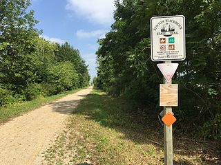
The Newton Blackmour State Trail is a crushed limestone trail in northern Outagamie County in Wisconsin. The trail spans 24 miles (39 km) on a former rail corridor. Its name is derived from the four communities the trail passes through: New London, Shiocton, Black Creek and Seymour. The trail's eastern end in Seymour connects to the Duck Creek Trail, which travels east through the Oneida Nation of Wisconsin and ends in the Village of Oneida.

The Duck Creek Trail is a crushed limestone trail in Outagamie and Brown Counties in northeast Wisconsin. The Duck Creek Trail spans seven miles (11 km), beginning at the eastern end of the Newton Blackmour State Trail, just east of Vanderheuvel Road in Seymour. The trail continues east through the Oneida Nation of Wisconsin in northern Outagamie County paralleling State Route 54, and continues to the Village of Oneida. The Duck Creek Trail will eventually extend to Pamperin Park in Green Bay.

The Mountain-Bay State Trail is an 83-mile state-designated rail trail in Brown, Marathon, and Shawano Counties in Wisconsin. The trail is the longest rail trail in the state.
The Nicolet State Trail is an 89-mile state designated trail running through Nicolet National Forest in Florence, Forest, and Oconto Counties in Wisconsin.

The Friendship Trail is a recreation trail in northeastern Wisconsin. The trail is used by walkers, hikers, bikers, horseback riders, and snowmobilers during the winter months. Two sections of the trail are complete: ~14 miles from Winchester east to Fox Crossing and ~4.4 miles from Forest Junction southeast to Brillion. The route consists of asphalt, crushed stone, and wood surfaces. The entire route is located in Winnebago County and Calumet County.
The Milwaukee and Northern Railway Company (M&N) is a former railroad company that built a railroad connecting Milwaukee, Green Bay, and Michigan's Upper Peninsula.