Frontenac Islands

Last updated

Frontenac Islands
Township of Frontenac Islands
Wolfe island canada.jpg
Satellite view of Frontenac Islands, with Wolfe Island being the largest
Canada Southern Ontario location map 2.png
Red pog.svg
Frontenac Islands
Coordinates: 44°12′N76°23′W / 44.200°N 76.383°W / 44.200; -76.383
CountryFlag of Canada (Pantone).svg  Canada
ProvinceFlag of Ontario.svg Ontario
County Frontenac
Incorporated1998
Government
  TypeTownship
  MayorJudith Anne Greenwood-Speers
  Fed. riding Kingston and the Islands
  Prov. riding Kingston and the Islands
Area
[1]
  Land176.82 km2 (68.27 sq mi)
Population
 (2021) [1]
  Total
1,930
  Density10.9/km2 (28/sq mi)
Time zone UTC-5 (EST)
  Summer (DST) UTC-4 (EDT)
Postal Code
K0H
Area codes 613, 343
Website www.frontenacislands.ca OOjs UI icon edit-ltr-progressive.svg

Frontenac Islands is a township located in Frontenac County, Ontario, Canada, that encompasses a number of islands at the beginning of the St. Lawrence River near the outlet of Lake Ontario, including Arabella, Bayfield, Black Ant, Garden, Goose, Hickory, Horseshoe, Howe, Wolfe, and Simcoe.[ citation needed ]

Contents

The township was formed on January 1, 1998, when Howe Island Township and Wolfe Island Township were merged as part of the county's reorganization. [2]

Communities

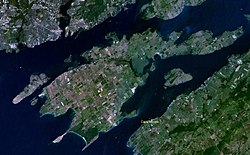
Of the several islands that make up Frontenac Islands, only three (Wolfe Island, Howe Island, and Simcoe Island ranked in descending order of year-round resident population) have substantial permanent resident populations, and regularly scheduled or on-demand marine ferry service provides year-round vehicle and emergency services access to those islands.

The other islands are accessible only by private boat to privately owned docks. Some of these islands have substantial numbers of homes and cottages, but are generally not populated during the winter months when ice build-up in Lake Ontario and the St. Lawrence River make boat access difficult or impossible.

Only Wolfe Island has a recognizable concentrated settlement: the village of Marysville, with around 400 inhabitants. The rest of the population is dispersed, mostly in lot groupings on or near the island shoreline, but with some housing found along the interior roads on either farm properties or on smaller non-farming lot severances.

In the nineteenth century, the islands had much larger populations. Small population clusters were also found in the Port Alexandria, Port Metcalf and Scotch Settlement areas, all on Wolfe Island. These communities are now no more than names on the map.

Note: There were no "villages" at Port Alexandria, Port Metcalf or the Scotch Settlement. The Scotch Settlement was a farming area encompassing approximately 3,000 acres which was settled in the 1820s by Scottish clansmen moving west from Glengarry county.[ citation needed ]

Demographics

In the 2021 Census of Population conducted by Statistics Canada, Frontenac Islands had a population of 1,930 living in 903 of its 1,212 total private dwellings, a change of 9.7% from its 2016 population of 1,760. With a land area of 176.82 km2 (68.27 sq mi), it had a population density of 10.9/km2 (28.3/sq mi) in 2021. [1]

Canada census – Frontenac Islands community profile
2021 2016 2011
Population1,930 (+9.7% from 2016)1,760 (-5.6% from 2011)1,864 (+0.1% from 2006)
Land area176.82 km2 (68.27 sq mi)175.04 km2 (67.58 sq mi)175.04 km2 (67.58 sq mi)
Population density10.9/km2 (28/sq mi)10.1/km2 (26/sq mi)10.6/km2 (27/sq mi)
Median age59.6 (M: 59.6, F: 59.6)55.9 (M: 56.0, F: 55.8)50.5 (M: 50.4, F: 50.6)
Private dwellings1,212 (total)  903 (occupied)1,273 (total) 1,256 (total) 
Median household income$90,000$80,512
References: 2021 [3] 2016 [4] 2011 [5]

Mother tongue (2021): [1]

Historical census populations – Frontenac Islands
YearPop.±%
1996 1,661    
2001 1,638−1.4%
2006 1,862+13.7%
2011 1,864+0.1%
2016 1,760−5.6%
2021 1,930+9.7%
Source: Statistics Canada [1] [6] [7]
Wolfe Island Wind Farm Wolfe island wind farm ls 09.JPG
Wolfe Island Wind Farm

Community groups and organizations

There are several community groups and organizations in the Frontenac Islands. On Wolfe Island, these include the Community Medical Clinic, the Wolfe Island Historical Society, the Wolfe Island Commons, and Wolfe Island Friends of Ferals.

Education

The town, along with Central Frontenac, South Frontenac and North Frontenac, sends students to schools part of the Limestone District School Board, based in neighboring Kingston.

See also

References

  1. 1 2 3 4 5 "Frontenac Islands (Code 3510005) Census Profile". 2021 census . Government of Canada - Statistics Canada . Retrieved 2025-04-04.
  2. "Municipal restructuring activity summary table - Dataset - Ontario Data Catalogue". data.ontario.ca. Government of Ontario. Retrieved 2025-04-04.
  3. "2021 Community Profiles". 2021 Canadian census . Statistics Canada. February 4, 2022. Retrieved 2023-10-19.
  4. "2016 Community Profiles". 2016 Canadian census . Statistics Canada. August 12, 2021. Retrieved 2019-06-13.
  5. "2011 Community Profiles". 2011 Canadian census . Statistics Canada. March 21, 2019. Retrieved 2012-02-13.
  6. 1996, 2001, 2006 census
  7. "Frontenac Islands, Ontario (Code 3510005) census profile". 2011 Census of Population . Statistics Canada. Retrieved 2012-02-13.