Frytown, Iowa

Last updated
Frytown, Iowa
Frytown Iowa.jpg
USA Iowa location map.svg
Red pog.svg
Frytown
Coordinates: 41°34′12″N91°43′57″W / 41.57000°N 91.73250°W / 41.57000; -91.73250 Coordinates: 41°34′12″N91°43′57″W / 41.57000°N 91.73250°W / 41.57000; -91.73250
Country United States
State Iowa
County Johnson
Area
[1]
  Total0.810 sq mi (2.10 km2)
  Land0.810 sq mi (2.10 km2)
  Water0 sq mi (0 km2)
Elevation
801 ft (244 m)
Population
 (2010) [1]
  Total165
  Density200/sq mi (79/km2)
Time zone UTC-6 (Central (CST))
  Summer (DST) UTC-5 (CDT)
Area code(s) 319
GNIS feature ID463065 [2]

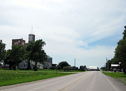
Frytown is an unincorporated community and census-designated place in Johnson County, Iowa, United States, approximately 10 miles southwest of Iowa City. The town has been known as Frytown since the 19th century, and is listed as such on state maps; the USGS once called it Williamstown, though it has since changed the name. [3] [2]

Frytown Conservation Area, a woodlands park belonging to Johnson County, is located about one mile northeast of Frytown.

The cemetery on the east end of town has markers for the original Fry family, who were immigrants to the area, including Samuel Preston Fry (and wife Fionna Melinda Grosscup) and his father, Titus R Fry (wife, Jane Preston).Jacob Fry 1785-1842. Yoder is the other prominent name in the Church of Christ graveyard.

As of the 2010 Census, the population of Frytown was 165. [4]

Related Research Articles

Fillmore County, Minnesota U.S. county in Minnesota

Fillmore County is a county in the U.S. state of Minnesota. As of the 2010 United States Census, the population was 20,866. Its county seat is Preston.

Sioux County, Iowa U.S. county in Iowa

Sioux County is a county located in the U.S. state of Iowa. As of the 2010 census, the population was 33,704. Its county seat is Orange City.

Sac County, Iowa U.S. county in Iowa

Sac County is a county located in the U.S. state of Iowa. As of the 2010 census, the population was 10,350. The county seat is Sac City. Both were named for the Sauk people, Native Americans who controlled this region before the European Americans.

Plymouth County, Iowa U.S. county in Iowa

Plymouth County is a county located in the U.S. state of Iowa. As of the 2010 census, the population was 24,986. The county seat is Le Mars. Plymouth County was named after Plymouth, Massachusetts.

Johnson County, Iowa U.S. county in Iowa

Johnson County is a county located in the U.S. state of Iowa. As of the 2010 census, the population was 130,882 making it the fifth-most populous county in Iowa. The county seat is Iowa City, home of the University of Iowa. The county is named for Richard Mentor Johnson, the ninth vice president of the United States.

Jackson County, Iowa U.S. county in Iowa

Jackson County is a county located in the U.S. state of Iowa. As of the 2010 census, the population was 19,848. The county seat is Maquoketa.

Clive, Iowa City in Iowa, United States

Clive is a city in Dallas and Polk counties in the U.S. state of Iowa. As of the 2010 Census the population is 15,447. It is part of the Des Moines–West Des Moines Metropolitan Statistical Area. Clive is known for its Greenbelt Park and trail system running through the community. Clive serves as the axis of the western Des Moines suburbs, between Urbandale, Waukee and West Des Moines along the major transportation corridors of I-35, I-80 and I-235. The City of Urbandale is to the north to northwest, the City of West Des Moines is to the southeast to southwest, the City of Waukee in Dallas County is to the west.

Burlington, Iowa City in Iowa, United States

Burlington is a city and the county seat of Des Moines County, Iowa, United States. The population was 25,663 in the 2010 census, a decline from the 26,839 population in the 2000 census. Burlington is the center of a micropolitan area including West Burlington, Iowa, and Middletown, Iowa, and Gulfport, Illinois. Burlington is the home of Snake Alley, once labelled the crookedest alley in the world.

Miles, Iowa City in Iowa, United States

Miles is a small city in southeastern Jackson County, Iowa, United States. The population was 445 at the 2010 census.

Preston, Iowa City in Iowa, United States

Preston is a city in Jackson County, Iowa, United States. The population was 1,012 at the 2010 census.

Moville, Iowa City in Iowa, United States

Moville is a city in Woodbury County, Iowa, United States. It is part of the Sioux City, IA–NE–SD Metropolitan Statistical Area. The population was 1,618 in the 2010 census, an increase from 1,583 in 2000. There is also a Moville on the Inishowen Peninsula in County Donegal, Ireland.

Shawnee, Kansas City in Kansas, United States

Shawnee is a city in Johnson County, Kansas, United States and is part of the Kansas City metropolitan area. As of the 2010 census, the city population was 62,209 with a 2018 estimate of 65,845.

Carthage, Missouri City in Missouri, United States

Carthage is a city in Jasper County, Missouri, United States. The population was 14,378 at the 2010 census. It is the county seat of Jasper County and is nicknamed "America's Maple Leaf City."

Moberly, Missouri City in Missouri, United States

Moberly is a city in Randolph County, Missouri, United States. The population was 13,974 at the 2010 census. It is part of the Columbia, Missouri metropolitan area.

{{Infobox settlement bill = Lake Preston, South Dakota bob = |native_name = |nickname = |settlement_type =City |motto =

Lamesa, Texas City in Texas, United States

Lamesa is a city in and the county seat of Dawson County, Texas, United States. The population was 9,422 at the 2010 census, down from 9,952 at the 2000 census. Located south of Lubbock on the Llano Estacado, Lamesa was founded in 1903. Most of the economy is based on cattle ranching and cotton farming. The Preston E. Smith prison unit, named for the former governor of Texas, is located just outside Lamesa.

Iowa City metropolitan area human settlement in United States of America

The Iowa City Metropolitan Statistical Area, as defined by the United States Census Bureau, is an area consisting of two counties in Iowa anchored by the city of Iowa City. The Metropolitan Statistical Area (MSA) had a population of 171,491 people in the 2017 US Census Bureau population estimate. growing 12.39% compared to 2010.

Sharon Township is one of the twenty townships of Johnson County, Iowa, United States. It is located on the southern county line, about 6 miles (9.7 km) southwest of Iowa City. It is adjacent to Washington, Union and Liberty Townships, as well as Washington County.

Dewey, South Dakota Unincorporated community in South Dakota, United States

Dewey is an unincorporated community near the southwest corner of Custer County, South Dakota, less than 1 mile from the Wyoming border in a prairie region of the Black Hills. There are approximately five or six homes in town. Dewey has a volunteer fire department in the Edgemont city district.

References

  1. 1 2 "2010 Census Gazetteer Files - Places: Iowa". U.S. Census Bureau . Retrieved April 7, 2018.
  2. 1 2 "Frytown". Geographic Names Information System . United States Geological Survey.
  3. Folks in Frytown say maps mistaken, USA Today, 26 Oct 2007, https://www.usatoday.com/news/offbeat/2007-10-25-frytown_N.htm
  4. https://www.census.gov/2010census/popmap/ipmtext.php?fl=1929325