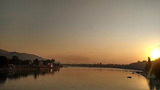
Haridwar is a city and municipal corporation in the Haridwar district of Uttarakhand, India. With a population of 228,832 in 2011, it is the second-largest city in the state and the largest in the district.
New Tehri is a city and a municipal board in Tehri Garhwal District in the Indian state of Uttarakhand. It is the administrative headquarters of Tehri Garhwal District. This urban municipality area has 11 wards, from Vidhi Vihar to Vishwakarma Puram.

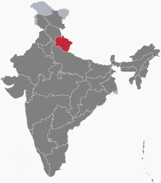
Uttarakhand, formerly known as Uttaranchal, is a state in northern India. The state is bordered by Himachal Pradesh to the northwest, Tibet to the north, Nepal to the east, Uttar Pradesh to the south and southeast, with a small part touching Haryana in the west. Uttarakhand has a total area of 53,483 km2 (20,650 sq mi), equal to 1.6 per cent of the total area of India. Dehradun serves as the state capital, with Nainital being the judicial capital. The state is divided into two divisions, Garhwal and Kumaon, with a total of 13 districts. The forest cover in the state is 45.4 per cent of the state's geographical area. The cultivable area is 16 per cent of the total geographical area. The two major rivers of the state, the Ganges and its tributary Yamuna, originate from the Gangotri and Yamunotri glaciers respectively.

Pauri is a town and a municipal board in Pauri Garhwal district in the Indian state of Uttarakhand. Pauri is the seat of the Divisional Commissioner of the Garhwal Division.

Devprayag is a town and a nagar panchayat, near New Tehri city in Tehri Garhwal District in the state of Uttarakhand, India, and is the final one of the Panch Prayag of Alaknanda River where Alaknanda meets the Bhagirathi river and both rivers thereafter flow on as the Ganges river or Ganga.
Rajaji National Park is a national park and tiger reserve in the Indian state of Uttarakhand. that encompasses the Shivaliks, near the foothills of the Himalayas. It covers 820 km2 (320 sq mi) and is included in three districts of Uttarakhand—Haridwar, Dehradun and Pauri Garhwal. In 1983, three wildlife sanctuaries in the area were merged into one.

Dehradun district is a district in Garhwal which is a part of Uttarakhand state in northern India. The district headquarters is Dehradun, which has also served as the interim capital of Uttarakhand since its founding in 2000. The district has 6 tehsils, 6 community development blocks, 17 towns and 764 inhabited villages, and 18 unpopulated villages. As of 2011, it is the second most populous district of Uttarakhand, after Haridwar. Dehradun district also includes the prominent towns of Rishikesh, Mussoorie, Landour and Chakrata. The district stretches from the Ganges river in the east to the Yamuna river in the west, and from the Terai and Shivaliks in the south and southeast to the Great Himalaya in the northwest. During the days of British Raj, the official name of the district was Dehra Dun. In 1842, Dun was attached to Saharanpur district and placed under an officer subordinate to the Collector of the district but since 1871 it is being administered as separate district.

Haridwar district, also spelled Hardwar, is part of Uttarakhand, India that lies in the Doab region, where people traditionally speak Khariboli. It is headquartered at Haridwar which is also its largest city. The district is ringed by the districts Dehradun in the north and east, Pauri Garhwal in the east and the Uttar Pradesh districts of Muzaffarnagar and Bijnor in the south and Saharanpur in the west.

Pauri Garhwal is a district in the Indian state of Uttarakhand. Its headquarters is in the town of Pauri. It is sometimes referred to simply as Garhwal district, though it should not be confused with the larger Garhwal region of which it is only a part of.

Lansdowne is a cantonment town in Pauri Garhwal is a district in the Indian state of Uttarakhand.
Chandpur is a town and a municipal board in Bijnor district in the Indian state of Uttar Pradesh, India.

Gauchar is a Hill Town sort of a valley town located in Karnaprayag tehsil within Chamoli district of Uttarakhand state in India. Gauchar is situated on the left bank of river Alaknanda and is en route to the celebrated holy destination of Badrinath. It is well known for being one of the cleanest place in country. It has previously topped Swachta sarvekshan best ganga town award. Situated at an altitude of 800 metres (2,620 ft) above the sea level, Gauchar is surrounded by seven mountains. Gauchar is well known for its historic trade fair and airstrip. Gauchar town known for its great work to curb loss of lives in 2013 flood disaster of Uttarakhand. This town is unique in terms of its geographical location and topography. Gauchar is located on one of the largest pieces of flatland in this mountainous region of Uttarakhand. Education institution in Gauchar includes a beautiful Kendriya Vidyalaya adjacent to the main playground.

Kotdwar is a city, municipal corporation in Pauri Garhwal district of Uttarakhand, India. It is just 101 km from Pauri, the district headquarter. It is the eighth-largest city in Uttarakhand. Its old name was "Kootdwar", which means the gateway of the high hill koot as Chitra koot, since it is located on the bank of river Khoh. It is situated in the southwestern part of the state and is one of the main entrance points in the state of Uttarakhand.
Chamba is a town and a hill station, nearby New Tehri City in Tehri Garhwal district in the state of Uttarakhand, India. It is situated at a junction of roads connecting Mussoorie and Rishikesh with the Tehri Dam reservoir and New Tehri. The town is about 50 km from Mussoorie and also near Dhanaulti, Surkanda Devi Temple, Ranichauri, New Tehri, and Kanatal, tipri halfway between Chamba and Dhanaulti.Chamba is situated at an altitude of 1600m above sea level. One can reach Chamba in about 7-8 hrs from Delhi via Haridwar, Rishikesh and Narendranagar (290 km).
Chilla is a wilderness area and part of Rajaji National Park in India. Known as an electricity creator area in the Pauri Garhwal district in the Indian state of Uttarakhand. It is also well known as a wild tourist place of Uttarakhand, standing in the middle of Rishikesh and Haridwar, nearby Ganga Bhogpur.

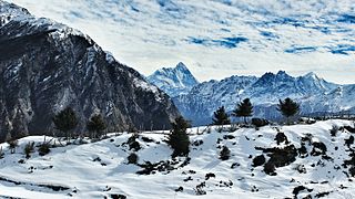
Uttarakhand has a total geographic area of 53,483 km2, of which 86% is mountainous and 65% is covered by forest. Most of the northern parts of the state are part of Greater Himalaya ranges, covered by the high Himalayan peaks and glaciers, while the lower foothills were densely forested till denuded by the British log merchants and later, after independence, by forest contractors. Recent efforts in reforestation, however, have been successful in restoring the situation to some extent. The unique Himalayan ecosystem plays host to many animals, plants and rare herbs. Two of India's great rivers, the Ganges and the Yamuna take birth in the glaciers of Uttarakhand, and are fed by myriad lakes, glacial melts and streams.

Matkunda is a village in the Thalisain tehsil of Bironkhal block in Pauri Garhwal district, Uttarakhand, India.

The following outline is provided as an overview of and topical guide to Uttarakhand:
Gadkhark is a village in the Thalisain tehsil of Bironkhal block in Pauri Garhwal district, Uttarakhand, India.


