
Pauri is a town and a municipal board in Pauri Garhwal district in the Indian state of Uttarakhand. Pauri is the seat of the Divisional Commissioner of the Garhwal Division.

Devprayag is a town and a nagar panchayat, near New Tehri city in Tehri Garhwal District in the state of Uttarakhand, India, and is the final one of the Panch Prayag of Alaknanda River where Alaknanda meets the Bhagirathi river and both rivers thereafter flow on as the Ganges river or Ganga.

Nainital district is a district in Kumaon division which is a part of Uttarakhand state in India. The headquarters is at Nainital.
Pauri Garhwal is a district in the Indian state of Uttarakhand. Its headquarters is in the town of Pauri. It is sometimes referred to simply as Garhwal district, though it should not be confused with the larger Garhwal region of which it is only a part of.

Rudraprayag is a district of the state of Uttarakhand of northern India. The district occupies an area of 1984 km2. The town of Rudraprayag is the administrative headquarters of the district. The district is bounded by Uttarkashi District on the north, Chamoli District on the east, Pauri Garhwal District on the south, and Tehri Garhwal District on the west.

Lansdowne is a cantonment town in Pauri Garhwal is a district in the Indian state of Uttarakhand.
Chandpur is a town and a municipal board in Bijnor district in the Indian state of Uttar Pradesh, India.
Dugadda, sometimes spelled Dogadda, is a town and a municipal board in Pauri Garhwal district in the state of Uttarakhand, India. Dugadda is a small town which is surrounded by mountains and situated on the banks of the Khoh River.

Gauchar is a Hill Town sort of a valley town located in Karnaprayag tehsil within Chamoli district of Uttarakhand state in India. Gauchar is situated on the left bank of river Alaknanda and is en route to the celebrated holy destination of Badrinath. It is well known for being one of the cleanest place in country. It has previously topped Swachta sarvekshan best ganga town award. Situated at an altitude of 800 metres (2,620 ft) above the sea level, Gauchar is surrounded by seven mountains. Gauchar is well known for its historic trade fair and airstrip. Gauchar town known for its great work to curb loss of lives in 2013 flood disaster of Uttarakhand. This town is unique in terms of its geographical location and topography. Gauchar is located on one of the largest pieces of flatland in this mountainous region of Uttarakhand. Education institution in Gauchar includes a beautiful Kendriya Vidyalaya adjacent to the main playground.
Kashirampur is a census town in Pauri Garhwal District in the Indian state of Uttarakhand.

Srinagar is a city and municipal corporation in Pauri Garhwal district in the Indian state of Uttarakhand. It is located about 33 km from Pauri town, the administrative headquarters of Pauri Garhwal district, Uttarakhand, India.
Bagar is a small village in Pauri Garhwal district in the Indian state of Uttarakhand. The population of Bagar is around 1,275, 644 being male, and 631 being female; 247 children, ages 0 to 6, live there as of 2011. Literacy rates run around an average of 53.4%, with 66.8% for men and 40.12% for women. Bagar covers a wide geographical area of 155.22 hectares.
Ganga Bhogpur also known as "Kodia" is a village in Yamkeshwar block in Pauri Garhwal District in the Indian state of Uttarakhand.
Raidul is a small village, a hill station, a popular holiday destination in Pauri Garhwal district in the Indian state of Uttarakhand.
Thalisain is a town and tehsil of Pauri Garhwal district in the North Indian state of Uttarakhand. At an elevation of 1690 metres from sea level, it is situated on a gentle slope above the right bank of Nayaar (East) river. It is in the southwestern foothills of Dudhatoli Range and at a distance of 83 kilometers from Pauri town and 95 kilometers from Gairsain, the future capital of Uttarakhand.

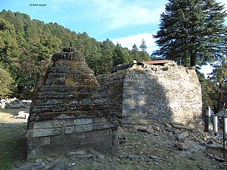
The hill temple of Kalinka is situated in Bironkhal block of Pauri Garhwal district, Uttarakhand in northern India. The temple complex lies close to the border with the Almora district and is dedicated to Goddess Kali. The temple has been in existence for centuries but the new structure has been renovated a couple of times in the last decade. It is often confused with Bunkhal kalinka, which is near Malund village of Raath region in Thalisain.
Haldukhata is a village under tehsil Kotdwar in the Pauri Garhwal district of Indian state of Uttarakhand. Haldukhata is connecting place for Kalaghati and Kishanpuri.
Lee, is a small village located in Pauri Tehsil of Pauri Garhwal district, Uttarakhand India.
Gadkhark is a village in the Thalisain tehsil of Bironkhal block in Pauri Garhwal district, Uttarakhand, India.
Bironkhal Tehsil is a administrative division located in the Pauri Garhwal district of the Indian state of Uttarakhand. It is one of the 14 tehsils in the district and is headquartered in the town of Syunsi. It was created in 2016 with 367 villages taken from Dhumakot, Chaubattakhal and Thalisain tehsils. The main languages spoken in the area are Hindi and Garhwali.
