Gangalidda, Queensland

Last updated

Gangalidda
Queensland
Australia Queensland location map.svg
Red pog.svg
Gangalidda
Coordinates 16°57′46″S138°59′11″E / 16.9627°S 138.9863°E / -16.9627; 138.9863 (Gangalidda (centre of locality))
Population0 (2021 census) [1]
 • Density0.0000/km2 (0.000/sq mi)
Postcode(s) 4825
Area273.7 km2 (105.7 sq mi)
Time zone AEST (UTC+10:00)
Location
LGA(s) Aboriginal Shire of Doomadgee
State electorate(s) Traeger
Federal division(s) Kennedy
Suburbs around Gangalidda:
Nicholson Gulf of Carpentaria Gulf of Carpentaria
Nicholson Gangalidda Gulf of Carpentaria
Nicholson Nicholson Nicholson

Gangalidda is a coastal locality in the Aboriginal Shire of Doomadgee, Queensland, Australia, on the Gulf of Carpentaria. [2] In the 2021 census, Gangalidda had "no people or a very low population". [1]

Contents

Geography

The waters of the Gulf of Carpentaria form the north-eastern boundary. [3]

Bayley Point ( 16°55′00″S139°02′00″E / 16.9167°S 139.0333°E / -16.9167; 139.0333 (Bayley Point) ) [4] is a small blunt point on the coast within the locality, directly opposite Bayley Island, rising to about 500 metres (1,600 ft). [5] [6]

History

In 1933 the Doomadgee Aboriginal Mission was established at Bayley Point by the Open Brethren. However, the location was remote and lacked a reliable water supply. After a cyclone destroyed the mission in 1936, [7] the mission was relocated approximately 115 kilometres (71 mi) south on the Nicholson River to present day Doomadgee. [8]

Prior to the creation of the Aboriginal Shire of Doomadgee in 2007, this land around the Bayley Point area was part of the locality of Nicholson in the Shire of Burke. After the creation of the new shire in 2007, the land became part of the new shire but retained the name of Nicholson. On 28 August 2009, it was renamed Gangalidda [2] (the Yukulta / Ganggalidda people being one of the two traditional owners of the land in the Doomadgee area, the other being the Waanyi people). [9]

Demographics

In the 2016 census, Gangalidda had "no people or a very low population". [10]

In the 2021 census, Gangalidda had "no people or a very low population". [1]

Education

There are no schools in Gangalidda nor nearby. The options are distance education and boarding school. [11]

Related Research Articles

<span class="mw-page-title-main">Weipa</span> Town in Queensland, Australia

Weipa is a coastal mining town in the local government area of Weipa Town in Queensland. It is one of the largest towns on the Cape York Peninsula. It exists because of the enormous bauxite deposits along the coast. The Port of Weipa is mainly involved in exports of bauxite. There are also shipments of live cattle from the port.

<span class="mw-page-title-main">Normanton, Queensland</span> Town in Queensland, Australia

Normanton is an outback town and coastal locality in the Shire of Carpentaria, Queensland, Australia. At the 2021 census, the locality of Normanton had a population of 1,391 people, and the town of Normanton had a population of 1,326 people.

<span class="mw-page-title-main">Mornington Island</span> Island off the coast of Australia

Mornington Island, also known as Kunhanhaa, is an island in the Gulf of Carpentaria in the Shire of Mornington, Queensland, Australia. It is the northernmost and largest of 22 islands that form the Wellesley Islands group. The largest town, Gununa, is in the south-western part of the island.

<span class="mw-page-title-main">Far North Queensland</span> Region in Queensland, Australia

Far North Queensland (FNQ) is the northernmost part of the Australian state of Queensland. Its largest city is Cairns and it is dominated geographically by Cape York Peninsula, which stretches north to the Torres Strait, and west to the Gulf Country. The waters of Torres Strait include the only international border in the area contiguous with the Australian mainland, between Australia and Papua New Guinea.

<span class="mw-page-title-main">Kowanyama, Queensland</span> Town in Queensland, Australia

Kowanyama is a town and coastal locality in the Aboriginal Shire of Kowanyama, Queensland, Australia.

<span class="mw-page-title-main">Pormpuraaw, Queensland</span> Town in Queensland, Australia

Pormpuraaw is a coastal town and a locality in the Aboriginal Shire of Pormpuraaw, Queensland, Australia. Pormpuraaw is an Aboriginal community situated on the west coast of Cape York Peninsula approximately halfway between Karumba and Weipa on the Edward River. It is 650 kilometres (400 mi) by road from Cairns. Pormpuraaw currently has a 4-man police station.

Doomadgee is a town and a locality in the Aboriginal Shire of Doomadgee, Queensland, Australia. It is a mostly Indigenous community, situated about 140 kilometres (87 mi) from the Northern Territory border, and 93 kilometres (58 mi) west of Burketown.

<span class="mw-page-title-main">Karumba, Queensland</span> Town in Queensland, Australia

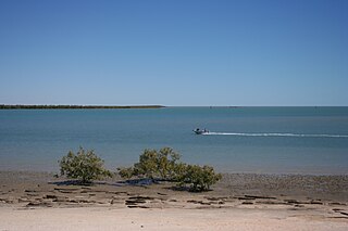
Karumba is a town and a coastal locality in the Shire of Carpentaria, Queensland, Australia. In the 2021 census, the locality of Karumba had a population of 487 people.

<span class="mw-page-title-main">Burketown</span> Town in Queensland, Australia

Burketown is an isolated outback town and coastal locality in the Shire of Burke, Queensland, Australia. In the 2021 census, the locality of Burketown had a population of 204 people.

<span class="mw-page-title-main">Shire of Burke</span> Local government area in Queensland, Australia

The Shire of Burke is a local government area in North West Queensland, Australia. The shire lies on the south coast of the Gulf of Carpentaria and abuts the border with the Northern Territory. It covers an area of 39,864 square kilometres (15,391.6 sq mi), and has existed as a local government entity since 1885. The major town and administrative centre of the shire is Burketown.

<span class="mw-page-title-main">Shire of Mornington (Queensland)</span> Local government area in Queensland, Australia

The Shire of Mornington is a local government area in northwestern Queensland, Australia. The shire covers the Wellesley Islands, which includes Mornington Island; the South Wellesley Islands; Bountiful Islands; and West Wellesley / Forsyth Islands groups in the Gulf of Carpentaria.

<span class="mw-page-title-main">Aboriginal Shire of Doomadgee</span> Local government area in Queensland, Australia

The Aboriginal Shire of Doomadgee is a special local government area in North West Queensland, Queensland, Australia. It is managed under a Deed of Grant in Trust under the Local Government Act 2004.

<span class="mw-page-title-main">Gulf Country</span> Queensland region

The Gulf Country or North West Queensland is the region of woodland and savanna grassland surrounding the Gulf of Carpentaria in north western Queensland and eastern Northern Territory on the north coast of Australia. The region is also called the Gulf Savannah. The Gulf Country is crossed by the Savannah Way highway.

<span class="mw-page-title-main">Duchess, Queensland</span> Town in Queensland, Australia

Duchess is a rural town and locality in the Shire of Cloncurry, Queensland, Australia. In the 2021 census, the locality of Duchess had a population of 53 people.

The Nicholson River is a river in the Northern Territory and the state of Queensland, Australia.

<span class="mw-page-title-main">Lawn Hill, Queensland</span> Suburb of Shire of Burke, Queensland, Australia

Lawn Hill is an outback locality split between the Shire of Burke and the City of Mount Isa in Queensland, Australia. The locality is on the Queensland border with the Northern Territory. In the 2021 census, Lawn Hill had a population of 63 people.

Nicholson is a coastal locality in the Shire of Burke, Queensland, Australia. It is on the border with the Northern Territory. In the 2021 census, Nicholson had a population of 32 people.

<span class="mw-page-title-main">Aboriginal Shire of Mapoon</span> Local government area in Queensland, Australia

The Aboriginal Shire of Mapoon is a local government area in Far North Queensland, Australia. It is on the western coast of Cape York Peninsula on the Gulf of Carpentaria. In the 2021 census, the Aboriginal Shire of Mapoon had a population of 432 people.

<span class="mw-page-title-main">Carpentaria, Queensland</span> Suburb of Shire of Carpentaria, Queensland, Australia

Carpentaria is a coastal locality in the Shire of Carpentaria, Queensland, Australia. In the 2021 census, Carpentaria had a population of 25 people.

The West Wellesley Islands, also referred to as the Forsyth Islands, is an island group and locality in the Gulf of Carpentaria within the Shire of Mornington, Queensland, Australia. The group lies to the south-west of the Wellesley Islands, closer to mainland Australia. The island group comprises four islands: Forsyth Island, Ivis Island, Pains Island and Bayley Island.

References

  1. 1 2 3 Australian Bureau of Statistics (28 June 2022). "Gangalidda (SAL)". 2021 Census QuickStats. Retrieved 28 February 2023. OOjs UI icon edit-ltr-progressive.svg
  2. 1 2 "Gangalidda – locality in Doomadgee Aboriginal Shire (entry 45902)". Queensland Place Names. Queensland Government . Retrieved 27 November 2018.
  3. Google (14 August 2021). "Gangalidda, Queensland" (Map). Google Maps . Google. Retrieved 14 August 2021.
  4. "Bayley Point – point in the Doomadgee Aboriginal Shire (entry 1912)". Queensland Place Names. Queensland Government . Retrieved 5 May 2019.
  5. "Bayley Pt". SLS Beachsafe. Archived from the original on 28 March 2022. Retrieved 10 October 2020.
  6. "Map of Bayley Point, QLD". Bonzle. Archived from the original on 9 September 2023. Retrieved 10 October 2020.
  7. "Also Damaged By Cyclone". The Telegraph . Queensland, Australia. 27 March 1936. p. 3 (SECOND EDITION). Archived from the original on 17 October 2020. Retrieved 5 May 2019 via National Library of Australia.
  8. "Old Doomadgee Mission (1933 - 1936)". Find & Connect. Australian Government. 4 June 2014. Archived from the original on 22 March 2019. Retrieved 5 May 2019.
  9. "Doomadgee". Department of Aboriginal and Torres Strait Islander Partnerships. Queensland Government. 6 July 2017. Archived from the original on 21 March 2019. Retrieved 5 May 2019.
  10. Australian Bureau of Statistics (27 June 2017). "Gangalidda (SSC)". 2016 Census QuickStats. Retrieved 20 October 2018. OOjs UI icon edit-ltr-progressive.svg
  11. "Layers: Locality; Schools and school catchments". Queensland Globe. Queensland Government. Archived from the original on 19 December 2017. Retrieved 8 September 2023.