The first recorded names of the hill in the Middle Ages were Kelen-hegy, Pesti-hegy (English: Pest Hill) and Blocksberg. Since the 15th century, it has been called Szent Gellért hegye (lit. the hill of St. Gerard), referring to the legend about the death of St. Gerard. The bishop was assassinated by the pagans during the great pagan rebellion in 1046. He was put in a barrel and rolled down into the deep from the top of the hill.
The former name, Pesti-hegy (Latin: Mons Pestiensis) referred to the large cave (now Gellért Hill Cave) in the hillside. The word is probably of Slavic origin and means oven or cave.[1]
The Ottoman Turks called the hill Gürz Elyas bayiri.[2]Gürz Elyas was a holy man from the Bektashi order whose shrine and grave on top of the hill was a place of pilgrimage in the 17th century.[3]
Geology
The hill belongs to the Buda Hills but, in a narrow sense, it connects to the southern Buda range consisting also Sashegy. These hills are based on main dolomite from the Late Triassic epoch, although the hills themselves arose later in the Pleistocene along a tectonic breakline. This explains also the origin of the hot springs all around the area. The caves are the result of the breaklines and the springs. The most significant among them is the Gellért Hill Cave with the Sziklatemplom (English: Cave Church).[4]
History
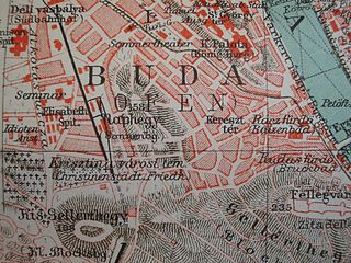
Naphegy and Tabán in Budapest 1905 Meyers Lexikon
After the assassination of St. Gerard, the hill was not populated. The dense forest and rocks gave way to legends of witches holding their ceremonies on the hill.
From the 18th century the hillsides were covered with vineyards. The Tabán district at the foot of the hill was an important centre of winemaking in Buda. According to the 1789 land register vineyards covered 128 hectares (316 ac) on the hill (only 7.62 hectares or 18.8 ac were used as pastures).[5]
A small calvary was built on the top of the hill which was rebuilt around 1820. On Easter Mondays a procession climbed the steep road leading to the calvary to celebrate the resurrection of Christ. Many tents and vendors were erected on the nearby meadow. Emmausjárás (En: Emmaus-walk) or tojásbúcsú (En: Egg Feast) was one of the most popular Catholic holidays of the year during the 18th–19th centuries.[6]
Gellért Hill also saw action in the Second World War and the 1956 Hungarian Revolution, when Soviet tanks fired down into the city from the hill.[citation needed] Indeed, battle scars still pockmark some buildings in Budapest.[citation needed] There is a small military museum in the Citadella’s grounds.[7] At the end of the Citadella is the Liberty Statue (Szabadság Szobor in Hungarian), a large monument erected by the Soviet Red Army to commemorate their victory in World War II.[8]
Today
Now an affluent residential area, a number of embassies and ambassadorial residences line the streets that wind up the hill. Since 1987, the area has been a UNESCO World Heritage site as part of "the Banks of the Danube".
A large proportion of the hill consists of parkland. Bats and hedgehogs are commonly observed on summer nights.
In January 2007, a new cave was discovered under Gellért Hill during private construction. The cave is 60 m long and 18 m deep with three rooms. The interior is covered with dazzling white crystals composed of gypsum, calcite, and aragonite. The cave was created 300,000–500,000 years ago by a now disappeared thermal spring. The crystal cave was immediately placed under legal protection.[9]
Gallery
Gellért Hill from Tűzkő Hill
View toward Gellért hill from József-hegy lookout tower
↑ Eltűnt budai szőlők nyomában[He disappeared in the wake of the vineyards of Buda] (in Hungarian). Vol.3. 2007. p.52.{{cite book}}: |work= ignored (help)
Buda is the part of Budapest, the capital city of Hungary, that lies on the western bank of the Danube. Historically, “Buda” referred only to the royal walled city on Castle Hill, which was constructed by Béla IV between 1247 and 1249 and subsequently served as the capital of the Kingdom of Hungary from 1361 to 1873. In 1873, Buda was administratively unified with Pest and Óbuda to form modern Budapest.
Pest is the part of Budapest, the capital city of Hungary, that lies on the eastern bank of the Danube. Pest was administratively unified with Buda and Óbuda in 1873; prior to this, it was an independent city. In colloquial Hungarian, "Pest" is sometimes also used pars pro toto to refer to Budapest as a whole.
Liberty Bridge or Freedom Bridge in Budapest, Hungary, connects Buda and Pest across the River Danube. It is the third southernmost public road bridge in Budapest, located at the southern end of the City Centre. It was originally named Ferenc József híd (Franz Joseph Bridge).
Elisabeth Bridge is the third newest bridge of Budapest, Hungary, connecting Buda and Pest across the River Danube. The bridge is situated at the narrowest part of the Danube in the Budapest area, spanning only 290 m. It is named after Elisabeth of Bavaria, a popular queen and empress of Austria-Hungary, who was assassinated in 1898. Today, her large bronze statue sits by the bridge's Buda side connection in the middle of a small garden.
The Tabán usually refers to an area within the 1st district of Budapest, the capital of Hungary. It lies on the Buda side of the Danube, to the south of György Dózsa Square, on the northern side of Elisabeth Bridge and to the east of Naphegy. Several other Hungarian cities and towns also have districts called Tabán.
The Halászbástya or Fisherman's Bastion is one of the best known historical monuments in Budapest, located near the Buda Castle, in the Várkerület. Since 1987, it has been designated a UNESCO World Heritage Site as part of the Várkerület District.
The Hotel Gellért is a historic Art Nouveau hotel established in 1918 and located on the west bank of the Danube in Budapest, Hungary.
Central Hungary is one of the eight statistical regions in Hungary. It includes Pest County and since 2018 no longer includes Budapest, the capital of the region.
Sashegy is a hill and neighbourhood in Budapest, Hungary. It is a green, upper middle class area in Buda with expensive family homes. Administratively Sashegy is divided between the 11th and the 12th districts of Budapest.
The Citadella is the fortification located upon the top of Gellért Hill in Budapest, Hungary. Citadella is the Hungarian word for citadel, a kind of fortress. The word is exclusively used by other languages to refer to the Gellért Hill citadel which occupies a place which held strategic importance in Budapest's military history.
Naphegy is a hill and neighbourhood in Budapest, Hungary. It is part of Krisztinaváros and administratively belongs to the 1st District.
Krisztina Téri Iskola a 220-year-old historic school in the I. district of Budapest, Krisztinaváros, Hungary.
János Hill is the highest point of Budapest with a height of 528 m (1,732 ft), located in the western part of the city. From Elizabeth Lookout on the top of the hill one can get an impressive panoramic view of the whole region.
Gellért Hill Calvary was a Late Baroque calvary on Gellért Hill, Budapest which was demolished around 1950.
District XVII of Budapest is a suburban district of Budapest on the left bank of the Danube, in the eastern part of the capital. It is Budapest's largest district, with an area of 54.82 km2, and home to nearly 90,000 people, making it the seventh most populous district of Budapest. Towns that were different in nature, but closely connected, were annexed to the capital in 1950 as part of the Greater Budapest plan. It is one of the most beautifully located districts of Pest, which is partly located as high as the 235 meters Gellért Hill. As the district is part of the Pest Plain, which gradually rises from the Danube to the east, the district's area is almost entirely hilly. The 241 meter high Erdő Hill, the highest point of the Pest side and the Pest Plain is also located here.
Hárshegy is a part of Budapest's 2nd district. Its entire area is made up of Nagy-Hárs Hill and Kis-Hárs Hill, from which there are sweeping views of Budapest. The area is a popular place for recreation, and the Hárs-hegy railway station of the Children's Railway is located in there.
The 1st District of Budapest is the Castle District and is the historical part of the Buda side of Budapest. It consists of the Buda Castle Hill and some other neighborhoods around it, like Tabán, Krisztinaváros and parts of Gellért Hill.
The Castle Quarter is the part of Buda in Budapest, the capital city of Hungary, that lies within the defensive walls of the Buda Castle complex, corresponding to the medieval royal city of Buda. Located on Várhegy, it is the oldest part of Budapest, having been continuously inhabited since 1247. The center of the neighborhood are the streets between the Royal Palace and Matthias Church.
The St. Catherine of Alexandria Church is a Roman Catholic church in the Tabán quarter of Budapest, Hungary. It is the parish church of the Tabán Parish which also comprises parts of Gellért Hill and Naphegy. The church is a listed monument that was built in Central European Baroque style between 1728 and 1777. It was reconstructed several times in the 19th–20th centuries.
This page is based on this Wikipedia article Text is available under the CC BY-SA 4.0 license; additional terms may apply. Images, videos and audio are available under their respective licenses.