
The Erie Canal is a historic canal in upstate New York that runs east–west between the Hudson River and Lake Erie. Completed in 1825, the canal was the first navigable waterway connecting the Atlantic Ocean to the Great Lakes, vastly reducing the costs of transporting people and goods across the Appalachians. In effect, the canal accelerated the settlement of the Great Lakes region, the westward expansion of the United States, and the economic ascendancy of New York State. It has been called "The Nation's First Superhighway."
Monroe County is a county in the Finger Lakes region of the U.S. state of New York, along Lake Ontario's southern shore. As of 2022, the population was 752,035, according to Census Bureau estimates. Its county seat and largest city is Rochester. The county is named after James Monroe, the fifth president of the United States. Monroe County is part of the Rochester, NY Metropolitan Statistical Area.

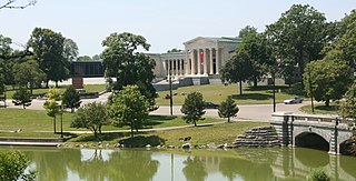
Letchworth State Park is a 14,427-acre (5,838 ha) New York State Park located in Livingston County and Wyoming County in the western part of the State of New York. The park is roughly 17 miles (27 km) long, following the course of the Genesee River as it flows north through a deep gorge and over several large waterfalls. It is located 35 miles (56 km) southwest of Rochester and 60 miles (97 km) southeast of Buffalo, and spans portions of the Livingston County towns of Leicester, Mount Morris and Portage, as well as the Wyoming County towns of Castile and Genesee Falls.
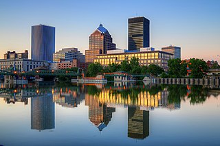
Rochester is a city in the U.S. state of New York and the seat of Monroe County. It is the fourth-most populous city and 10th most-populated municipality in New York, with a population of 211,328 at the 2020 census. The city forms the core of the larger Rochester metropolitan area in Western New York, with a population of over 1.09 million residents. Throughout its history, Rochester has acquired several nicknames based on local industries; it has been known as "the Flour City" and "the Flower City" for its dual role in flour production and floriculture, and as the "Imaging Capital of the World" for its association with film and still photography.

Brighton is a town in Monroe County, New York, United States. The population was 37,137 at the 2020 census.

Pittsford is an incorporated town in Monroe County, New York. A suburb of Rochester, its population was 30,617 at the time of the 2020 census.

The Genesee River is a tributary of Lake Ontario flowing northward through the Twin Tiers of Pennsylvania and New York in the United States. The river contains several waterfalls in New York at Letchworth State Park and Rochester.

Western New York (WNY) is the westernmost region of the U.S. state of New York. The eastern boundary of the region is not consistently defined by state agencies or those who call themselves "Western New Yorkers". Almost all sources agree WNY includes the cities of Buffalo, Niagara Falls, Jamestown, and the surrounding suburbs, as well as the outlying rural areas of the Great Lakes lowlands and Niagara Frontier, and Chautauqua-Alleghany. Many would also place Rochester and the Genesee Valley in the region, while some would also include the western Finger Lakes within the region. Others would describe the latter three areas as being in a separate Finger Lakes region.

Interstate 390 (I-390) is a 76.06-mile (122.41 km) north–south auxiliary Interstate Highway located entirely within New York in the United States. The southern terminus of the route is at the Southern Tier Expressway in the town of Avoca. Its northern terminus is at I-490 in Gates, just west of Rochester. North of I-490, the expressway continues as NY 390 to the Lake Ontario State Parkway in Greece. I-390 connects to its parent, I-90, in Henrietta, a southern suburb of Rochester. The route is known as the Genesee Expressway from Avoca to I-590 in Brighton, where it becomes part of the Rochester Outer Loop.

Settlement of the city of Rochester in western New York State began in the late 18th century, and the city flourished with the opening of the Erie Canal. It became a major manufacturing center, and attracted many Italians, Germans, Irish and other immigrants, as well as a dominant group of Yankees of New England origin. The Yankees made Rochester the center of multiple reform movements, such as abolitionism and women's rights. It was famous as the center of the American photography industry and the headquarters of Eastman Kodak. In the 1970s it became fashionable to use the term "Rust Belt" for the industrial cities along the Great Lakes following the move away from steel, chemical and other hard goods manufacturing. Rochester, with the presence of Ritter-Pfaudler, Bausch and Lomb, Eastman Kodak, Xerox, Gannett and other major industries, defied the trend for many decades following World War II.

Interstate 490 (I-490) is an auxiliary Interstate Highway that serves the city of Rochester, New York, in the United States. It acts as a northerly alternate route to the New York State Thruway (I-90), leaving it at exit 47 in the town of Le Roy and rejoining the highway at exit 45 in the town of Victor 37.4 miles (60.2 km) to the east. I-490 connects with I-390 and New York State Route 390 (NY 390) on the western side of Rochester and I-590 and NY 590 on the east side of the city at an interchange known as the Can of Worms. The highway comprises the southernmost portion of the Inner Loop, a beltway around the interior of Rochester. Outside the city, I-490 serves several suburban villages, such as Churchville and Pittsford.
Riverton, New York, was a planned community built in 1973 in the town of Henrietta, New York, along the Genesee River. Riverton was seventh of the thirteen communities receiving federal guarantee assistance from HUD as part of their New Communities Program created by the Urban Growth and New Community Development Act of 1970. $12 million was earmarked for the community. Riverton was supposed to encompass a 2,335-acre (9 km2) land area bordered on the north by the New York State Thruway, on the west by the Genesee River, on the east by East River Rd., and on the south by the Rush-Henrietta town line, with some development continuing east along Erie Station Rd. Original plans called for construction to occur for a 16-year period and eventually house over 25,000 people, with the community including an 18-hole golf course, 12 swimming pools, 3 artificial lakes, a marina on the Genesee, and commercial and industrial centers. However, only a small portion of this was built along Scottsville-West Henrietta Rd. Created as part of the community were Riverton Knolls, a moderately priced townhouse subdivision, the Riverton Golf Club, a small 9-hole golf course, and the Riverton Park, which included a playground, baseball diamond, river front benches, walking trail, and a volleyball court. Also nestled in a bend in the Genesee was a 28-acre (110,000 m2) forested nature park.

The New York State Canal System is a successor to the Erie Canal and other canals within New York. The 525-mile (845 km) system is composed of the Erie Canal, the Oswego Canal, the Cayuga–Seneca Canal, and the Champlain Canal. In 2014 the entire system was listed as a national historic district on the National Register of Historic Places, and in 2016 it was designated a National Historic Landmark.

New York State Route 383 (NY 383) is an 18.70-mile (30.09 km) north–south state highway in Monroe County, New York, in the United States. The southern terminus of the route is at an intersection with NY 36 in the hamlet of Mumford within the Town of Wheatland. Its northern terminus is at a junction with NY 31 in the city of Rochester. The route follows the Genesee River and its tributaries for its entire length and passes through the village of Scottsville.
Many of the public parks and parkways system of Buffalo, New York, were originally designed by Frederick Law Olmsted and Calvert Vaux between 1868 and 1896. They were inspired in large part by the parkland, boulevards, and squares of Paris, France. They include the parks, parkways and circles within the Cazenovia Park–South Park System and Delaware Park–Front Park System, both listed on the National Register of Historic Places and maintained by the Buffalo Olmsted Parks Conservancy.

The Genesee Valley Greenway is a rail trail in western New York's Genesee River valley.

The Great Lakes Seaway Trail, formerly named and commonly known as the Seaway Trail, is a 518-mile (834 km) National Scenic Byway in the northeastern United States, mostly contained in New York but with a small segment in Pennsylvania. The trail consists of a series of designated roads and highways that travel along the Saint Lawrence Seaway—specifically, Lake Erie, the Niagara River, Lake Ontario, and the Saint Lawrence River. It begins at the Ohio state line in rural Erie County, Pennsylvania, and travels through several cities and villages before ending at the Seaway International Bridge northeast of the village of Massena in St. Lawrence County, New York. It is maintained by the non-profit Seaway Trail, Inc.

The Veterans Memorial Bridge in Rochester, New York, carries New York State Route 104 across the Genesee River. The bridge is an architecturally significant concrete arch faced with white granite. Conceived in 1928 and finished in 1931, the span is the longest bridge in Rochester at 981 feet (299 m). It is 190 feet (58 m) in height and 106 feet (32 m) wide.
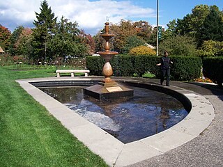
Maplewood Park, also known as Seneca Park West, is a landscaped public park in Rochester, New York, situated between Lake Avenue and the Genesee River. The two-mile-long (3.2 km) park features many trails along the river gorge and the river bank below, scenic views of two waterfalls and a nationally accredited Rose Garden.
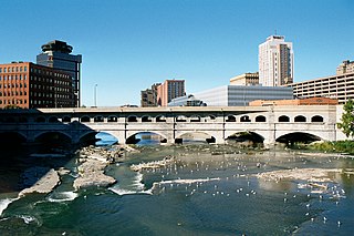
Erie Canal: Second Genesee Aqueduct, also known as the Broad Street Aqueduct or Broad Street Bridge, is a historic stone aqueduct located at Rochester in Monroe County, New York. It was constructed in 1836–1842 and originally carried the Erie Canal over the Genesee River. The overall length of the aqueduct including the wings and abutments is 800 feet (240 m). The aqueduct is 70 feet (21 m) wide and has large parapets on either side. It is one of four major aqueducts in the mid-19th century Erie Canal system. In 1927, a roadbed was added to carry automobile traffic and named Broad Street. It also carried a part of the Rochester Subway.


