The Great Rift Valley is a series of contiguous geographic depressions, approximately 6000 or 7,000 kilometres (4,300 mi) in total length, the definition varying between sources, that runs from the southern Turkish Hatay Province in Asia, through the Red Sea, to Mozambique in Southeast Africa. While the name continues in some usages, it is rarely used in geology as it is considered an imprecise merging of separate though related rift and fault systems.

The Horn of Africa (HoA), also known as the Somali Peninsula, is a large peninsula and geopolitical region in East Africa. Located on the easternmost part of the African mainland, it is the fourth largest peninsula in the world. It is composed of Somalia, Djibouti, Ethiopia, and Eritrea. Although not common, broader definitions include parts or all of Kenya and Sudan. It has been described as a region of geopolitical and strategic importance, since it is situated along the southern boundary of the Red Sea; extending hundreds of kilometres into the Gulf of Aden, Guardafui Channel, and Indian Ocean, it also shares a maritime border with the Arabian Peninsula.

Ethiopia is located in the Horn of Africa. It is bordered by Eritrea to the north, Djibouti and Somalia to the east, Sudan and South Sudan to the west, and Kenya to the south. Ethiopia has a high central plateau, the Abyssinian Highlands that varies from 1,290 to 3,000 m above sea level, with some 25 mountains whose peaks rise over 4,000 meters (13,200ft), the highest being Ras Dashen at 4,543 meters (14,538ft).
The Rift Valley lakes are a series of lakes in the East African Rift valley that runs through eastern Africa from Ethiopia in the north to Malawi in the south, and includes the African Great Lakes in the south. These include some of the world's oldest lakes, deepest lakes, largest lakes by area, and largest lakes by volume. Many are freshwater ecoregions of great biodiversity, while others are alkaline "soda lakes" supporting highly specialised organisms.

The East-Central Africa Division (ECD) of Seventh-day Adventists is a sub-entity of the General Conference of Seventh-day Adventists, which oversees the Church's work in portions of Africa, which includes the nations of Djibouti, Eritrea, Somalia, Ethiopia, Kenya, Tanzania, Uganda, Rwanda, Burundi, South Sudan and the Democratic Republic of the Congo. It was founded in 2003 and has its headquarters is in Nairobi, Kenya. Founded in 2003. The Division membership as of June 30, 2021 is 4,588,423.
Lowland East Cushitic is a group of roughly two dozen diverse languages of the Cushitic branch of the Afro-Asiatic family. Its largest representatives are Oromo and Somali.
The East African Rift (EAR) or East African Rift System (EARS) is an active continental rift zone in East Africa. The EAR began developing around the onset of the Miocene, 22–25 million years ago. It was formerly considered to be part of a larger Great Rift Valley that extended north to Asia Minor.
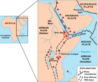
The Afar Triangle is a geological depression caused by the Afar Triple Junction, which is part of the Great Rift Valley in East Africa. The region has disclosed fossil specimens of the very earliest hominins; that is, the earliest of the human clade, and it is thought by some paleontologists to be the cradle of the evolution of humans. The Depression overlaps the borders of Eritrea, Djibouti and the entire Afar Region of Ethiopia; and it contains the lowest point in Africa, Lake Assal, Djibouti, at 155 m (509 ft) below sea level.
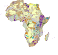
The Afromontane regions are subregions of the Afrotropical realm, one of the Earth's eight biogeographic realms, covering the plant and animal species found in the mountains of Africa and the southern Arabian Peninsula. The Afromontane regions of Africa are discontinuous, separated from each other by lower-lying areas, and are sometimes referred to as the Afromontane archipelago, as their distribution is analogous to a series of sky islands.

The Albertine Rift is the western branch of the East African Rift, covering parts of Uganda, the Democratic Republic of the Congo (DRC), Rwanda, Burundi and Tanzania. It extends from the northern end of Lake Albert to the southern end of Lake Tanganyika. The geographical term includes the valley and the surrounding mountains.
The Afar Triple Junction is located along a divergent plate boundary dividing the Nubian, Somali, and Arabian plates. This area is considered a present-day example of continental rifting leading to seafloor spreading and producing an oceanic basin. Here, the Red Sea Rift meets the Aden Ridge and the East African Rift. The latter extends a total of 6,500 kilometers (4,000 mi) from the Afar Triangle to Mozambique.

The Great Rift Valley of Ethiopia, is a branch of the East African Rift that runs through Ethiopia in a southwest direction from the Afar Triple Junction. In the past, it was seen as part of a "Great Rift Valley" that ran from Mozambique to Syria.

The Great Rift Valley is part of an intra-continental ridge system that runs through Kenya from north to south. It is part of the Gregory Rift, the eastern branch of the East African Rift, which starts in Tanzania to the south and continues northward into Ethiopia. It was formed on the "Kenyan Dome" a geographical upwelling created by the interactions of three major tectonics: the Arabian, Nubian, and Somalian plates. In the past, it was seen as part of a "Great Rift Valley" that ran from Madagascar to Syria. Most of the valley falls within the former Rift Valley Province.

The Gregory Rift is the eastern branch of the East African Rift fracture system. The rift is being caused by the separation of the Somali Plate from the Nubian Plate, driven by a thermal plume. Although the term is sometimes used in the narrow sense of the Kenyan Rift, the larger definition of the Gregory Rift is the set of faults and grabens extending southward from the Gulf of Aden through Ethiopia and Kenya into Northern Tanzania, passing over the local uplifts of the Ethiopian and Kenyan domes. Ancient fossils of early hominins, the ancestors of humans, have been found in the southern part of the Gregory Rift.

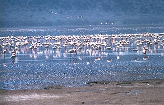
The greater Turkana Basin in East Africa determines a large endorheic basin, a drainage basin with no outflow centered around the north-southwards directed Gregory Rift system in Kenya and southern Ethiopia. The deepest point of the basin is the endorheic Lake Turkana, a brackish soda lake with a very high ecological productivity in the Gregory Rift.
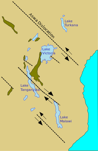
The Aswa Dislocation, also called the Aswa mylonite belt, Aswa Lineament or Aswa Shear Zone, is a north-west trending ductile shear zone that runs to the east of Lake Victoria in East Africa.
The geology of Djibouti consists largely of volcanic rocks from the Miocene to Holocene epochs. There are more recent alluvial deposits with coral on the coast, as well as Cenozoic sedimentary. Amba Aradam Sandstones from the Jurassic Period are found in the southeast of the country.
The geology of Uganda extends back to the Archean and Proterozoic eons of the Precambrian, and much of the country is underlain by gneiss, argillite and other metamorphic rocks that are sometimes over 2.5 billion years old. Sedimentary rocks and new igneous and metamorphic units formed throughout the Proterozoic and the region was partially affected by the Pan-African orogeny and Snowball Earth events. Through the Mesozoic and Cenozoic, ancient basement rock has weathered into water-bearing saprolite and the region has experienced periods of volcanism and rift valley formation. The East Africa Rift gives rise to thick, more geologically recent sediment sequences and the country's numerous lakes. Uganda has extensive natural resources, particularly gold.
Gymnosporia arbutifolia is a species of flowering plant in the family Celastraceae. It is a thorny shrub or tree native to eastern Africa and the Arabian Peninsula. It grows in the mountains of eastern Africa, from the Ethiopian Highlands to the Albertine Rift, and to the southeastern Arabian Peninsula, from 1350 to 2080 meters elevation.