Gigmoto

Last updated
Gigmoto
Municipality of Gigmoto
Gigmoto catanduanes 2.jpg
Poblacion
Flag of Gigmoto, Catanduanes.png
Ph locator catanduanes gigmoto.png
Map of Catanduanes with Gigmoto highlighted
OpenStreetMap
Gigmoto
Philippines location map (square).svg
Red pog.svg
Gigmoto
Location within the Philippines
Coordinates: 13°47′N124°23′E / 13.78°N 124.38°E / 13.78; 124.38
Country Philippines
Region Bicol Region
Province Catanduanes
District Lone district
Founded June 15, 1951
Barangays 9 (see Barangays)
Government
[1]
  Type Sangguniang Bayan
   Mayor Vicente J. Tayam Jr.
   Vice Mayor Jose T. Joson
   Representative Hector S. Sanchez
   Municipal Council
Members
   Electorate 7,647 voters (2022)
Area
[2]
  Total181.82 km2 (70.20 sq mi)
Elevation
155 m (509 ft)
Highest elevation
643 m (2,110 ft)
Lowest elevation
0 m (0 ft)
Population
 (2020 census) [3]
  Total8,712
  Density48/km2 (120/sq mi)
   Households
1,955
Economy
   Income class 5th municipal income class
   Poverty incidence
27.13
% (2018) [4]
   Revenue 87.51 million (2020)
   Assets 159.3 million (2020)
   Expenditure 65.33 million (2020)
   Liabilities 33.57 million (2020)
Service provider
  ElectricityFirst Catanduanes Electric Cooperative (FICELCO)
Time zone UTC+8 (PST)
ZIP code
4804
PSGC
IDD : area code +63(0)52
Native languages Tagalog
Website www.gigmoto-catanduanes.gov.ph

Gigmoto, officially the Municipality of Gigmoto, is a 5th class municipality in the province of Catanduanes, Philippines. According to the 2020 census, it has a population of 8,712 people. [3]

Contents

Gigmoto is 51 kilometres (32 mi) from Virac.

History

The name "Gigmoto" originated from the Bicol word himbot that means “just in time”. This is supposedly related to the romantic venture of a young man from Baras seeking to court a maiden from the town of Viga. Competing with several other suitors, the man traveled northbound to win the love of the maiden. He was overtaken by the night, so he slept in that place. In the morning he proceeded to Viga, arriving there just before nightfall. After staying for a period of time in Viga, the man from Baras won the heart of the woman. When the lovers were bound for Baras, they stayed overnight at Gigmoto – “just in time” for their first romantic night of being together.

As years went by Himbotan was changed to Higmoto. Years thereafter, believing that with the “H” Higmoto seemed to be a Japanese word, the “H” was changed to “G” – thus the name Gigmoto.

The first families to settle there were the Tanaels, followed by the Dayawons, both from Baras. The Tolledos, the Tatings and the Tatads came next. Other families from Baras, Bato and from the town of Virac had come and ultimately made Gigmoto the biggest barrio of the Municipality of Baras.

The town was created from the barrios of Sicmil and Sioron from Viga and the barrios of San Vicente, Gigmoto, Biong and Dororian from Baras. [5]

On June 15, 1951, the government officials for the newly created town were appointed by the then Congressman Severiano de Leon who authored the bill creating the municipality with the approval of President Elpidio Quirino. Mr. Juan Q. Sarmiento who happened to be the first public school teacher became the first mayor with Andres Dayawon as Vice Mayor. Messrs. Maximo Tapalla, Apolinar Tatad, Marcelino Dayawon and Apolinar Joson were then appointed municipal councilors. Mr. Candido Tuboro became the first municipal treasurer. Fr. Andres Tablizo was the parish priest and Mr. Serafin Rodulfo was the first principal.
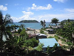
Geography

Barangays

Gigmoto is politically subdivided into 9 barangays. [6] Each barangay consists of puroks and some have sitios.

Climate

Climate data for Gigmoto
MonthJanFebMarAprMayJunJulAugSepOctNovDecYear
Average high °C (°F)29.3
(84.7)
29.6
(85.3)
30.5
(86.9)
31.4
(88.5)
32.3
(90.1)
32.6
(90.7)
32.3
(90.1)
32.4
(90.3)
32.2
(90.0)
31.4
(88.5)
30.7
(87.3)
29.7
(85.5)
31.2
(88.2)
Daily mean °C (°F)25.7
(78.3)
25.7
(78.3)
26.4
(79.5)
27.2
(81.0)
28.1
(82.6)
28.4
(83.1)
28.2
(82.8)
28.3
(82.9)
27.9
(82.2)
27.3
(81.1)
27.0
(80.6)
26.3
(79.3)
27.2
(81.0)
Average low °C (°F)22.1
(71.8)
21.9
(71.4)
22.3
(72.1)
23.1
(73.6)
23.9
(75.0)
24.2
(75.6)
24.1
(75.4)
24.2
(75.6)
23.7
(74.7)
23.3
(73.9)
23.3
(73.9)
22.9
(73.2)
23.2
(73.9)
Average rainfall mm (inches)420
(16.5)
345
(13.6)
334
(13.1)
148
(5.8)
200
(7.9)
224
(8.8)
319
(12.6)
209
(8.2)
331
(13.0)
687
(27.0)
944
(37.2)
731
(28.8)
4,892
(192.5)
Source: Climate-Data.org [7]

Gigmoto has a tropical rainforest climate (Af) with heavy to very heavy rainfall year-round and with extremely heavy rainfall from October to December.

Demographics

Population census of Gigmoto
YearPop.±% p.a.
1960 5,697    
1970 5,133−1.04%
1975 5,950+3.01%
1980 6,137+0.62%
1990 6,487+0.56%
1995 6,736+0.71%
2000 7,055+1.00%
2007 7,569+0.97%
2010 8,003+2.05%
2015 8,368+0.85%
2020 8,712+0.80%
Source: Philippine Statistics Authority [8] [9] [10] [11]

In the 2020 census, the population of Gigmoto was 8,712 people, [3] with a density of 48 inhabitants per square kilometre or 120 inhabitants per square mile.

Economy

Notable

Related Research Articles

<span class="mw-page-title-main">Claveria, Masbate</span> Municipality in Masbate, Philippines

Claveria, officially the Municipality of Claveria, is a 3rd class municipality in the province of Masbate, Philippines. According to the 2020 census, it has a population of 42,142 people. Ranked 592nd among 1,488 municipalities in the Philippines.

<span class="mw-page-title-main">Virac, Catanduanes</span> Capital of Catanduanes, Philippines

Virac, officially the Municipality of Virac, is a 1st class municipality and capital of the province of Catanduanes, Philippines. According to the 2020 census, it has a population of 76,520 people.

<span class="mw-page-title-main">San Vicente, Camarines Norte</span> Municipality in Camarines Norte, Philippines

San Vicente, officially the Municipality of San Vicente, is a 5th class municipality in the province of Camarines Norte, Philippines. According to the 2020 census, it has a population of 12,579 people.

<span class="mw-page-title-main">Bagamanoc</span> Municipality in Catanduanes, Philippines

Bagamanoc, officially the Municipality of Bagamanoc, is a 5th class municipality in the province of Catanduanes, Philippines. According to the 2020 census, it has a population of 11,086 people.

<span class="mw-page-title-main">Baras, Catanduanes</span> Municipality in Catanduanes, Philippines

Baras, officially the Municipality of Baras, is a 5th class municipality in the province of Catanduanes, Philippines. According to the 2020 census, it has a population of 13,484 people.

<span class="mw-page-title-main">Bato, Catanduanes</span> Municipality in Catanduanes, Philippines

Bato, officially the Municipality of Bato, is a 5th class municipality in the province of Catanduanes, Philippines. According to the 2020 census, it has a population of 21,748 people.

<span class="mw-page-title-main">Caramoran</span> Municipality in Catanduanes, Philippines

Caramoran, officially the Municipality of Caramoran, is a 3rd class municipality in the province of Catanduanes, Philippines. According to the 2020 census, it has a population of 32,114 people.

<span class="mw-page-title-main">Pandan, Catanduanes</span> Municipality in Catanduanes, Philippines

Pandan, officially the Municipality of Pandan, is a 4th class municipality in the province of Catanduanes, Philippines. According to the 2020 census, it has a population of 21,473 people.

<span class="mw-page-title-main">Panganiban, Catanduanes</span> Municipality in Catanduanes, Philippines

Panganiban, officially the Municipality of Panganiban, is a 5th class municipality in the province of Catanduanes, Philippines. According to the 2020 census, it has a population of 9,713 people.

<span class="mw-page-title-main">San Andres, Catanduanes</span> Municipality in Catanduanes, Philippines

San Andres, officially the Municipality of San Andres, is a 3rd class municipality in the province of Catanduanes, Philippines. According to the 2020 census, it has a population of 38,480 people.

<span class="mw-page-title-main">San Miguel, Catanduanes</span> Municipality in Catanduanes, Philippines

San Miguel, officially the Municipality of San Miguel, is a 5th class municipality in the province of Catanduanes, Philippines. According to the 2020 census, it has a population of 15,680 people.

<span class="mw-page-title-main">Viga, Catanduanes</span> Municipality in Catanduanes, Philippines

Viga, officially the Municipality of Viga, is a 4th class municipality in the province of Catanduanes, Philippines. According to the 2020 census, it has a population of 22,869 people.

<span class="mw-page-title-main">Pilar, Sorsogon</span> Municipality in Sorsogon, Philippines

Pilar, officially the Municipality of Pilar, is a 1st class municipality in the province of Sorsogon, Philippines. According to the 2020 census, it has a population of 75,793 people.

<span class="mw-page-title-main">Batuan, Masbate</span> Municipality in Masbate, Philippines

Batuan, officially the Municipality of Batuan, is a 5th class municipality in the province of Masbate, Philippines. According to the 2020 census, it has a population of 14,610 people.

<span class="mw-page-title-main">Dimasalang</span> Municipality in Masbate, Philippines

Dimasalang, officially the Municipality of Dimasalang, is a 4th class municipality in the province of Masbate, Philippines. According to the 2020 census, it has a population of 24,909 people.

<span class="mw-page-title-main">Palanas</span> Municipality in Masbate, Philippines

Palanas, officially the Municipality of Palanas, is a 4th class municipality in the province of Masbate, Philippines. According to the 2020 census, it has a population of 27,322 people.

<span class="mw-page-title-main">Pio V. Corpus</span> Municipality in Masbate, Philippines

Pio V. Corpus, officially the Municipality of Pio V. Corpus is a 4th class municipality in the province of Masbate, Philippines. According to the 2020 census, it has a population of 23,744 people.

<span class="mw-page-title-main">San Fernando, Masbate</span> Municipality in Masbate, Philippines

San Fernando, officially the Municipality of San Fernando, is a 5th class municipality in the province of Masbate, Philippines. According to the 2020 census, it has a population of 21,600 people.

<span class="mw-page-title-main">Canaman</span> Municipality in Camarines Sur, Philippines

Canaman, officially the Municipality of Canaman is a 3rd class municipality in the province of Camarines Sur, Philippines. According to the 2020 census, it has a population of 36,205 people. Canaman is known for its upscale shopping, heritage which dates back to Spanish era, and its new first class housings.

<span class="mw-page-title-main">Lagonoy</span> Municipality in Camarines Sur, Philippines

Lagonoy, officially the Municipality of Lagonoy, is a 2nd class municipality in the province of Camarines Sur, Philippines. According to the 2020 census, it has a population of 56,714 people.

References

  1. Municipality of Gigmoto | (DILG)
  2. "2015 Census of Population, Report No. 3 – Population, Land Area, and Population Density" (PDF). Philippine Statistics Authority. Quezon City, Philippines. August 2016. ISSN   0117-1453. Archived (PDF) from the original on May 25, 2021. Retrieved July 16, 2021.
  3. 1 2 3 Census of Population (2020). "Region V (Bicol Region)". Total Population by Province, City, Municipality and Barangay. Philippine Statistics Authority . Retrieved 8 July 2021.{{cite encyclopedia}}: CS1 maint: numeric names: authors list (link)
  4. "PSA Releases the 2018 Municipal and City Level Poverty Estimates". Philippine Statistics Authority. 15 December 2021. Retrieved 22 January 2022.
  5. "An act creating the municipality of Gigmoto in the province of Catanduanes". LawPH.com. Retrieved 2011-04-09.
  6. "Province: Catanduanes". PSGC Interactive. Quezon City, Philippines: Philippine Statistics Authority . Retrieved 12 November 2016.
  7. "Climate: Gigmoto". Climate-Data.org. Retrieved 27 October 2020.
  8. Census of Population (2015). "Region V (Bicol Region)". Total Population by Province, City, Municipality and Barangay. Philippine Statistics Authority . Retrieved 20 June 2016.{{cite encyclopedia}}: CS1 maint: numeric names: authors list (link)
  9. Census of Population and Housing (2010). "Region V (Bicol Region)" (PDF). Total Population by Province, City, Municipality and Barangay. National Statistics Office . Retrieved 29 June 2016.{{cite encyclopedia}}: CS1 maint: numeric names: authors list (link)
  10. Censuses of Population (1903–2007). "Region V (Bicol Region)". Table 1. Population Enumerated in Various Censuses by Province/Highly Urbanized City: 1903 to 2007. National Statistics Office.{{cite encyclopedia}}: CS1 maint: numeric names: authors list (link)
  11. "Province of Catanduanes". Municipality Population Data. Local Water Utilities Administration Research Division. Retrieved 17 December 2016.
  12. "Poverty incidence (PI):". Philippine Statistics Authority. Retrieved December 28, 2020.
  13. "Estimation of Local Poverty in the Philippines" (PDF). Philippine Statistics Authority. 29 November 2005.
  14. "2003 City and Municipal Level Poverty Estimates" (PDF). Philippine Statistics Authority. 23 March 2009.
  15. "City and Municipal Level Poverty Estimates; 2006 and 2009" (PDF). Philippine Statistics Authority. 3 August 2012.
  16. "2012 Municipal and City Level Poverty Estimates" (PDF). Philippine Statistics Authority. 31 May 2016.
  17. "Municipal and City Level Small Area Poverty Estimates; 2009, 2012 and 2015". Philippine Statistics Authority. 10 July 2019.
  18. "PSA Releases the 2018 Municipal and City Level Poverty Estimates". Philippine Statistics Authority. 15 December 2021. Retrieved 22 January 2022.