Gilberton, Queensland (Etheridge)

Last updated

Gilberton
Queensland
Australia Queensland location map.svg
Red pog.svg
Gilberton
Coordinates 19°16′26″S143°39′04″E / 19.27389°S 143.65111°E / -19.27389; 143.65111 Coordinates: 19°16′26″S143°39′04″E / 19.27389°S 143.65111°E / -19.27389; 143.65111
Location
LGA(s) Shire of Etheridge
State electorate(s) Traeger
Federal Division(s) Kennedy
Localities around Gilberton:
Northhead Forsayth Lyndhurst
Bellfield Gilberton Lyndhurst
Woolgar Porcupine Lyndhurst

Gilberton is a remote locality in the Shire of Etheridge, Queensland, Australia. [1]

Suburbs and localities are the names of geographic subdivisions in Australia, used mainly for address purposes. The term locality is used in rural areas, while the term suburb is used in urban areas. Australian postcodes closely align with the boundaries of localities and suburbs.
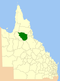
Shire of Etheridge Local government area in Queensland, Australia

The Shire of Etheridge is a local government area in Far North Queensland, Australia in what is known as the Savannah Gulf region. Its economy is based on cattle grazing and mining.

Queensland North-east state of Australia

Queensland is the second-largest and third-most populous state in the Commonwealth of Australia. Situated in the north-east of the country, it is bordered by the Northern Territory, South Australia and New South Wales to the west, south-west and south respectively. To the east, Queensland is bordered by the Coral Sea and Pacific Ocean. To its north is the Torres Strait, with Papua New Guinea located less than 200 km across it from the mainland. The state is the world's sixth-largest sub-national entity, with an area of 1,852,642 square kilometres (715,309 sq mi).

Contents

Geography

The old Gilberton township lies within a cattle station (privately owned by one family since 1869, which was established near Yangaa territory). The only remains of the town is the stone fortress that was built by the Martell family in 1869. The date palm on the northern side of the Gilbert River is the site of the Corbett store.

The Yangaa were an indigenous Australian people of the state of Queensland. They may be the same as the Nyangga. They are not to be confused with the Yangga.

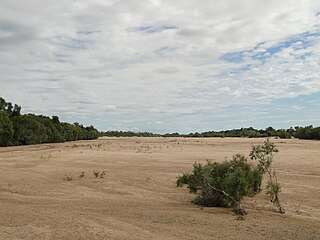
The Gilbert River flows from the south-east to the north-west of the locality and then travels northward towards its mouth at the Gulf of Carpentaria. Gilberton Station neighbors Rungullla National Park. [2]

Gilbert River (Queensland) river in Australia

The Gilbert River is a river located in Far North Queensland, Australia. When combined with the Einasleigh River, the river system is the largest river system in northern Australia.

Gulf of Carpentaria A large, shallow sea enclosed on three sides by northern Australia and bounded on the north by the Arafura Sea

The Gulf of Carpentaria is a large, shallow sea enclosed on three sides by northern Australia and bounded on the north by the Arafura Sea. The northern boundary is generally defined as a line from Slade Point, Queensland in the northeast, to Cape Arnhem, Northern Territory in the west.

Heritage listings

Gilberton has a number of heritage-listed sites, including:

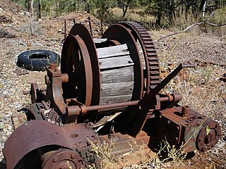
Ortona Mine and Battery

Ortona Mine and Battery is a heritage-listed mine at Forsayth-Agate Creek - Ortona (Iona) Station Road, Gilberton, Shire of Etheridge, Queensland, Australia. It was built from 1899 to 1908. It was added to the Queensland Heritage Register on 25 August 2000.

Mount Moran Battery

Mount Moran Battery is a heritage-listed former stamper battery at New Woolgar Road, Gilberton, Shire of Etheridge, Queensland, Australia. It was built from 1924 to c. 1936. It was added to the Queensland Heritage Register on 22 September 2000.

Joseph Morris Mine mine in Australia

Joseph Morris Mine is a heritage-listed former mine at Georgetown Mining District, Gilberton, Shire of Etheridge, Queensland, Australia. It was built from 1903 to 1910. It was added to the Queensland Heritage Register on 5 April 2004.

Related Research Articles

Croydon, Queensland Town in Queensland, Australia

Croydon is a town and locality within the Shire of Croydon in Queensland, Australia. At the 2011 census, the town and surrounding area recorded a population of 312 people. It is a terminus for the Normanton to Croydon railway line, which operates the Gulflander tourist train.

Forsayth, Queensland Town in Queensland, Australia

Forsayth is a town and locality in the Shire of Etheridge, Far North Queensland, Australia, approximately 415 kilometres (258 mi) by road from Cairns. In the 2011 census, Forsayth had a population of 347 people.

Georgetown, Queensland Town in Queensland, Australia

Georgetown is a town and locality in the Shire of Etheridge, Queensland, Australia. In the 2011 census, Georgetown had a population of 243 people.

Mount Surprise, Queensland Town in Queensland, Australia

Mount Surprise is a town and locality in the Shire of Etheridge, Queensland, Australia. In the 2011 census, Mount Surprise had a population of 306 people.

Ravenswood, Queensland Town in Queensland, Australia

Ravenswood is a small mining town and locality in the Charters Towers Region, Queensland, Australia. It is approximately 40 kilometres (25 mi) south of Mingela, and about 89 kilometres (55 mi) from Charters Towers. In the 2011 census, Ravenswood had a population of 349 people.

Monkland is a locality in the Gympie Region, Queensland, Australia.

Einasleigh, Queensland Town in Queensland, Australia

Einasleigh is a town and a locality in the Shire of Etheridge, Queensland, Australia. In the 2016 census, Einasleigh had a population of 92 people.

Kidston, Queensland Town in Queensland, Australia

Kidston is a town within the locality of Einasleigh, Shire of Etheridge, Queensland, Australia.

Kingsborough, Queensland Town in Queensland, Australia

Kingsborough is a small town in the locality of Thornborough in the Shire of Mareeba, Queensland, Australia. It was part of the Hodgkinson Minerals Area.

Mount Coolon, Queensland Suburb of Whitsunday Region, Queensland, Australia

Mount Coolon is a small town and locality in the Whitsunday Region, Queensland, Australia. In the 2011 census, Mount Coolon had a population of 567 people.

Thornborough, Queensland Town in Queensland, Australia

Thornborough is a town and locality in Shire of Mareeba in Queensland, Australia. It rose to prominence in the 1870s as a gold mining town in the Hodgkinson Minerals Area. Today, there are very few buildings remaining in the town. It is within the local government area of Shire of Mareeba.

Palmer, Queensland Suburb of Shire of Cook, Queensland, Australia

Palmer is a locality in the Shire of Cook, Queensland, Australia.

Yarraden, Queensland Suburb of Shire of Cook, Queensland, Australia

Yarraden is a coastal locality in the Shire of Cook, Queensland, Australia.

Selwyn, Queensland Suburb of Shire of Cloncurry, Queensland, Australia

Selwyn is a town and locality in the Shire of Cloncurry, Queensland, Australia. Selwyn is a now-abandoned mining town.

Aspasia Mine and Battery

Aspasia Mine and Battery is a heritage-listed mine and stamper battery at Gulf Developmental Road, Georgetown, Shire of Etheridge, Queensland, Australia. It was built from 1916 to 1952. It is also known as Mount Turner Battery. It was added to the Queensland Heritage Register on 13 April 2006.

Lyndhurst, Queensland Suburb of Shire of Etheridge, Queensland, Australia

Lyndhurst is a locality in the Shire of Etheridge, Queensland, Australia. In the 2016 census, Lyndhurst had a population of 8 people.

References

  1. "Gilberton (Etheridge Shire) (entry 41674)". Queensland Place Names. Queensland Government . Retrieved 25 June 2017.
  2. "Queensland Globe". State of Queensland . Retrieved 27 June 2016.
  3. "Mount Moran Battery (entry 601921)". Queensland Heritage Register . Queensland Heritage Council. Retrieved 7 July 2013.
  4. "Joseph Morris Mine (entry 601855)". Queensland Heritage Register . Queensland Heritage Council. Retrieved 7 July 2013.