It is about 22 miles (35km) inland from the Durban city centre at an elevation of 1800 feet (600 m ASL). Although Durban is semi-tropical and very humid, Gillitts is above the humidity and is not humid, except when it is in the clouds, which generally occurs in summer. It is in the mist belt area, so this area gets a fair amount of mist which many of the residents complain about.
While some residents do seem to complain about the mist, it does usually come as a welcome relief to the intense humidity of the area.
Gillitts has remained fairly stable while Kloof and Hillcrest in the surrounding areas are growing quite rapidly. This can be attributable to the fact that there is very little area for Gillitts to grow and as a result of growing in a very organic way it has maintained its rural atmosphere till this day.
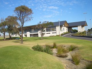
Gillitts originated as an extensive farm that extended over the whole of the Upper Highway area, but over time, the farm was sold off and now only the 100-year-old farmhouse remains inside the Gillitts Driving Range and 9-hole, mashie golf course. This golf course is one of the best designed courses of its size in KZN.
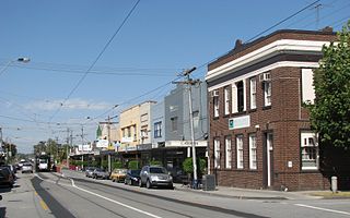
The area of Gillitts extends along either side of the M13 highway which stretches from Durban to Assagay. The M13 replaced the Old Main Road between the two cities, and a section of Old Main Road is now the major road through the south side of Gillitts.
Off of Stockville Road – one of the other main roads in Gillitts suburb – a large ethnic Indian population lives, and over the traditional Indian festivals, fireworks are very prominent as part of their celebrations, especially over Diwali and New Years.
On the northern side of the M13, known as Gillitts Park, the old train line from Durban to Pietermaritzburg winds through the residential areas. This train line is no longer in regular use, and is only used by the Umgeni Steam Railway, who runs a tourist service of carriages through from Kloof Train Station to Cato Ridge on the last Sunday of every month. This train is pulled by 'Maureen', a restored Class 3BR No. 1486 steam engine built in 1912 and the sound of the train whistle echoing through the neighbourhood on a Sunday morning is a reminder of a quieter time of life.
The Gillitts Train Station on the line in the middle of Gillitts is derelict and currently not used, but is a beautiful example of 1900-era architecture. Dating back to the Boer War in the first decade of the 20th century, the train station was a stop for British soldiers transiting from Durban through to the Midland battlefields as well as returning wounded soldiers.
During the Boer War, the Gillitts family farm held a garrison of British troops, who built a small dam for water and a camp in what is now Camp Road. The dam still exists in a picturesque natural park amongst the houses on what is now Ashley Drive and contains bass, barbel and other fish species as well as supporting a variety of other waterfowl.
The Gillitts Conservancy is a very active organisation who manages the Iphithi Nature Reserve in the middle of northern Gillitts. This nature reserve is a success story. Situated in a valley between two roads, it was a stand of invader species Blue Gum trees for 50 years until 2001. The residents bordering the valley organised a committee and contracted a logger to fell the Blue Gums. As the wood was valuable as timber, the committee was paid a lump sum which it used to found the nature reserve, fence off the additional entrances and pay for the laying of paths, building of viewing decks and planting of indigenous species. Today the Iphithi Nature Reserve is a 15 Hectare stand of indigenous forest, wetland and grasslands and home to many species of birds, small mammals and even a dam has been built which is populated with fish. The walks and park benches are popular with the residents and the park is quite heavily used on weekends.
With plot sizes of minimum half-an-acre, very few cluster developments, no commercial or industrial development and this very active environmentalist population, Gillitts still houses hundreds of birds and indigenous wildlife including small buck, duiker, Iphithi and porcupine.
In the first six months of 2009, we have seen an upsurge in housebreakings in the area. Traditionally an out-of-the-way neighbourhood, Gillitts Park has been largely spared the crime problems that the rest of the country has experienced. The recent upsurge in incidents has led to the formation of a neighbourhood watch association. Called the Gillitts Park Streetwatch, this organisation is composed of residents who have contracted a service provider to provide cellphone communications links between members. By watching out for each other and working with local law enforcement, the 860-home neighbourhood saw nine arrests of housebreakers in four weeks. The crime rate has since dropped off.
Gillitts Park is a small residential suburb of Durban, South Africa. Comprising the northern half of the suburb of Gillitts, Gillitts Park is a green beltresidential area with almost no commercial development and no industrial development. In its entirety, Gillitts Park consists of about 900 homes in freehold, residential sites with a minimum plot size of 0.5 acres (2,000m2). There are also about 200 cluster developmentunits scattered through the neighbourhood, the most prominent being Augusta Golf Estate. Situated about 30 kilometres (19mi) inland from Durban and at an altitude of 600 metres (2,000ft) above sea level, Gillitts Park experiences a warm year-round climate, with no frost or snow in winter and drastically reduced humidity when compared with the coastal suburbs. Commercial development is limited to home-offices, a small, single-storey office building and the Emberton Mashie Golf Course, 9-hole course as well as a driving range and coffee shop.
Having experienced an upsurge in residential housebreakings during the first half of 2009,[citation needed] residents banded together to form the Gillitts Park Streetwatch. This organisation is a 'Neighbourhood Watch'-type structure, with the additional function of re-creating a sense of community and maintaining the beautiful environment of the area.
Related Research Articles
Burwood is an inner eastern suburb of Melbourne, Victoria, Australia, 14 kilometres east of Melbourne's Central Business District, located within the Cities of Monash and Whitehorse local government areas. Burwood recorded a population of 15,147 at the 2021 census.
Malvern East is a suburb in Melbourne, Victoria, Australia, 13 km south-east of Melbourne's Central Business District, located within the City of Stonnington local government area. Malvern East recorded a population of 22,296 at the 2021 census.
York Mills is a neighbourhood in Toronto, Ontario, Canada. It is centred around Yonge Street and York Mills Road located in the district of North York. In 2010, it encompassed the fourth and seventh most affluent postal codes in Canada. It is recognized as a millionaires' mile, alongside the other Toronto neighbourhoods of The Bridlepath, Forest Hill, and Rosedale.
Hillcrest is a town in the KwaZulu-Natal province of South Africa that forms part of the eThekwini Metropolitan Municipality and is situated approximately 32 km north-west of Durban and 53 km south-east of Pietermaritzburg.
Kloof is a town that includes a smaller area called Everton, located approximately 26 km north-west of Durban in KwaZulu-Natal, South Africa. Once an independent municipality, it now forms part of greater Durban area of the eThekwini Metropolitan Municipality.
Pinetown is a city that forms part of the eThekwini Metropolitan Municipality, based just inland from Durban in KwaZulu-Natal, South Africa. The town is situated 16 km north-west of Durban and 64 km south-east of Pietermaritzburg.
Westville is an area in KwaZulu-Natal, South Africa, and is just west and 10 km inland from the Durban CBD. It was formerly and independent municipality and became part of the eThekwini Metropolitan Municipality in 2002.
The R103 is a Regional Route in South Africa that is the designation for some of the old sections of roads that were previously the N3, prior to upgrading. It only has 3 sections, from Hillcrest to Ladysmith, from Warden to Villiers and from Heidelberg to Johannesburg.
Eastlakes is an inner southern and eastern suburb of Sydney, in the state of New South Wales, Australia. Eastlakes is located 8 kilometres south of the Sydney central business district, in the local government area of the Bayside Council, Eastlakes is mostly residential with a shopping centre located at Evans Avenue. The residential portion of the suburb falls in the inner south being west of the Eastern Distributor while the non-residential side of the suburb consisting of The Lakes Golf Course and Botany Dams is east of the Eastern Distributor falling within the Eastern Suburbs, south-east of the CBD.
Bardwell Valley is a suburb in southern Sydney, in the state of New South Wales, Australia. Bardwell Valley is located approximately 12 kilometres south-west of the Sydney central business district, in the local government area of the Bayside Council and is part of the St George area.
The Upper Highway Area is a region west of the city of Durban in KwaZulu-Natal, South Africa. It is the suburban western part of the Greater Durban metropolitan area and extends from Kloof in the east to Botha’s Hill in the west. It includes the main towns of Hillcrest, Gillitts and Kloof and the smaller areas of Assagay, Botha’s Hill, Everton and Waterfall.
Winston Park is a small residential area between Gillitts and Hillcrest in the Upper Highway Area of KwaZulu-Natal, South Africa.
Humber Valley Village is a neighbourhood located in Toronto, Ontario, Canada. It is within the former suburb of Etobicoke and includes some of the most expensive real estate in the metropolitan west end. The boundaries are from Dundas Street on the south to Islington Avenue to the west, Eglinton Avenue to the north, and the Humber River in the east. The neighbourhood is in the political riding of Etobicoke Centre.
Randpark Ridge is an upmarket suburb of Randburg, South Africa. It is located in Region C of the City of Johannesburg. It fell into the town of Randburg during the apartheid era. Developed in the early 1980s and still relatively new, Randpark Ridge is bordered by several other suburbs including Weltevreden Park, Sundowner, Boskruin, Bromhof, Honeydew and Fairland.
Durban North is an area to the north of Durban in the eThekwini Metropolitan Municipality, KwaZulu-Natal, South Africa. Durban North lies between the N2 freeway and the eastern seashore, with the Umgeni River forming its southern boundary. It has residential suburbs that are some of Durban's most affluent and is flanked by La Lucia in the north.
The M13 is a metropolitan route in the Ethekwini Metropolitan Municipality in the KwaZulu-Natal province of South Africa. For most of its route, it is a highway named King Cetshwayo Highway and it acts as an alternative route to the N3 highway for travel between the suburbs closer to the Durban CBD and the Outer West Suburbs (Assagay).
Assagay, also spelt Assegay, is a suburb of eThekwini in KwaZulu-Natal, South Africa and forms a part of the Upper Highway Area.
Forest Hills is a suburb in the Outer West suburbs of Durban, Kwa-Zulu Natal, South Africa. The area borders on the Kloof Gorge which forms part of the Krantzkloof Nature Reserve, and is situated in between Kloof and Waterfall which is also about 7 km from Hillcrest. Forest Hills is referred to as being part of the Kloof area as they are both situated on opposite sides of the Kloof Gorge, as a result the areas are joined by one road which runs through the Kloof Gorge.
Stamford Hill is a suburb of Durban, KwaZulu-Natal, South Africa. It is administered by the eThekwini Metropolitan Municipality and its postal code is 4001.
Waterfall is a small residential area that lies north-east of Hillcrest in the province of KwaZulu-Natal, South Africa. Although Waterfall is officially regarded as a separate suburb from Hillcrest, it is often locally regarded as something of an extension of Hillcrest.
This page is based on this Wikipedia article Text is available under the CC BY-SA 4.0 license; additional terms may apply. Images, videos and audio are available under their respective licenses.