
The London Borough of Hounslow is a London borough in West London, England, forming part of Outer London. It was created in 1965 when three smaller borough councils amalgamated under the London Government Act 1963. It is governed by Hounslow London Borough Council.

The London Borough of Havering in East London, England, forms part of Outer London. It has a population of 259,552 inhabitants; the principal town is Romford, while other communities are Hornchurch, Upminster, Collier Row and Rainham. The borough is mainly suburban, with large areas of protected open space. Romford is a major retail and night time entertainment centre, and to the south the borough extends into the London Riverside redevelopment area of the Thames Gateway. The name Havering is a reference to the Royal Liberty of Havering which occupied the area for several centuries. The local authority is Havering London Borough Council. It is the easternmost London borough.

Caledon is a town in the Regional Municipality of Peel in the Greater Toronto Area of Ontario, Canada. The name comes from a shortened form of Caledonia, the Roman name for what is now Scotland. Caledon is primarily rural with a number of hamlets and small villages, but also contains the larger community of Bolton in its southeastern quadrant, adjacent to York Region. Some spillover urbanization also occurs in the south bordering the City of Brampton.

Woodford Green is an area of Woodford in East London, England, within the London Borough of Redbridge. It adjoins Buckhurst Hill to the north, Woodford Bridge to the east, South Woodford to the south, and Chingford to the west. Epping Forest runs through Woodford Green in the west of the area, 9.4 miles (15.1 km) north-east of Charing Cross.

Springvale is a suburb in Melbourne, Victoria, Australia, 22 km (14 mi) south-east of Melbourne's Central Business District, located within the City of Greater Dandenong local government area. Springvale recorded a population of 22,174 at the 2021 census.
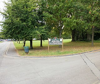
Heath is a district, community and coterminous electoral ward in the north of Cardiff, capital of Wales. It is a predominantly affluent area with property prices being the third highest in the city. The area is known for its traditional 1930s detached and semi-detached properties with large south facing gardens. Roads are tree lined and large greeneries with the notable attraction of Heath Park and the joining of the University Hospital of Wales.
Hillcrest is a town in the KwaZulu-Natal province of South Africa that forms part of the eThekwini Metropolitan Municipality and is situated approximately 32 km north-west of Durban and 53 km south-east of Pietermaritzburg.

Kloof is a leafy upper-class town, that includes a smaller area called Everton, located approximately 26 km north-west of Durban in KwaZulu-Natal, South Africa. Once an independent municipality, it now forms part of greater Durban area of the eThekwini Metropolitan Municipality.

Peterston-super-Ely is a village and community situated on the River Ely in the county borough of the Vale of Glamorgan, Wales. The community population at the 2011 census was 874. The community includes the hamlet of Gwern-y-Steeple.

Kardinya is a suburb 13 kilometres (8 mi) south-southwest of the central business district of Perth, the capital of Western Australia. It is in the City of Melville local government area. It is predominantly a low-density residential suburb consisting of single-family detached homes. There is a commercial area in the centre of the suburb, with a shopping centre and several other shops. In the northwest is a small light industrial area. Kardinya has a population of 8,730 people.
Embleton is a suburb of Perth, the capital city of Western Australia, located 7 kilometres (4.3 mi) north-east of the central business district, between the suburbs of Morley and Bayswater. Its local government area is the City of Bayswater.

Fulwood is a suburb of Preston, Lancashire, England, to the north of the city centre. It had a population of 28,535 in 2011 and since 2019, is made up of four electoral wards on the City Council.

Northiam is a village and civil parish in the Rother district, in East Sussex, England, 13 miles (21 km) north of Hastings in the valley of the River Rother. The A28 road to Canterbury and Hastings passes through it.
Gillitts is a town in the KwaZulu-Natal Province of South Africa.

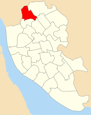
County ward is an electoral division of Liverpool City Council. The ward is within the Liverpool Walton Parliamentary constituency.
Milton is a residential area of the English city of Portsmouth, Hampshire, England, on the south eastern side of Portsea Island. Milton is bordered on the eastern coast of Portsea Island by Langstone Harbour, with Eastney to the south-east, Southsea to the south-west, Baffins to the north and Fratton to the north-west.
Warbreck ward was an electoral division of Liverpool City Council containing parts of the Walton and Orrell Park areas of Liverpool.

Ridleyton is an inner northern suburb of Adelaide, South Australia. It is located in the City of Charles Sturt.

Bush Hill Park is an area of Enfield, located to the south-east of Enfield Town, on the outskirts of north London, and historically in Middlesex. Much of the district is a planned suburban estate, developed mainly in the late-19th and early-20th centuries, and designated a conservation area in 1986.

Richard "Rick" Crouch is a former South African politician and City Councillor in the eThekwini Metropolitan Municipality representing the official opposition Democratic Alliance. Aside from being a former politician Crouch is a private investigator and a qualified commercial pilot.


