Drummond | |
---|---|
Drummond Station, 1891 | |
Coordinates: 29°45′36″S30°41′24″E / 29.760°S 30.690°E Coordinates: 29°45′36″S30°41′24″E / 29.760°S 30.690°E | |
Country | South Africa |
Province | KwaZulu-Natal |
Municipality | eThekwini |
Area | |
• Total | 7.72 km2 (2.98 sq mi) |
Population (2011) [1] | |
• Total | 955 |
• Density | 120/km2 (320/sq mi) |
Racial makeup (2011) | |
• Black African | 17.0% |
• Coloured | 0.8% |
• Indian/Asian | 1.8% |
• White | 79.0% |
• Other | 1.4% |
First languages (2011) | |
• English | 72.7% |
• Afrikaans | 11.3% |
• Zulu | 8.0% |
• Xhosa | 2.6% |
• Other | 5.4% |
Time zone | UTC+2 (SAST) |
PO box | 3626 |
Drummond is a town in eThekwini Metro in the KwaZulu-Natal province of South Africa.
eThekwini Metropolitan Municipality is a metropolitan municipality created in 2000, that includes the city of Durban, South Africa and surrounding towns. eThekwini is one of the 11 districts of KwaZulu-Natal province of South Africa. The majority of its 3,442,361 people speak Zulu. It was formed from seven formerly independent local councils and tribal land.
KwaZulu-Natal is a province of South Africa that was created in 1994 when the Zulu bantustan of KwaZulu and Natal Province were merged. It is located in the southeast of the country, enjoying a long shoreline beside the Indian Ocean and sharing borders with three other provinces and the countries of Mozambique, Eswatini and Lesotho. Its capital is Pietermaritzburg and its largest city is Durban. It is the 2nd most populous province in South Africa, with slightly fewer residents than Gauteng.
South Africa, officially the Republic of South Africa (RSA), is the southernmost country in Africa. It is bounded to the south by 2,798 kilometres (1,739 mi) of coastline of Southern Africa stretching along the South Atlantic and Indian Oceans; to the north by the neighbouring countries of Namibia, Botswana, and Zimbabwe; and to the east and northeast by Mozambique and Eswatini (Swaziland); and it surrounds the enclaved country of Lesotho. South Africa is the largest country in Southern Africa and the 25th-largest country in the world by land area and, with over 57 million people, is the world's 24th-most populous nation. It is the southernmost country on the mainland of the Old World or the Eastern Hemisphere. About 80 percent of South Africans are of Sub-Saharan African ancestry, divided among a variety of ethnic groups speaking different African languages, nine of which have official status. The remaining population consists of Africa's largest communities of European (White), Asian (Indian), and multiracial (Coloured) ancestry.
Village 45 km west of Durban. It was named after F C Drummond, former director of the Natal Land and Colonisation Company. [2]
Durban is the third most populous city in South Africa—after Johannesburg and Cape Town—and the largest city in the South African province of KwaZulu-Natal. Located on the east coast of South Africa, Durban is famous for being the busiest port in the country. It is also seen as one of the major centres of tourism because of the city's warm subtropical climate and extensive beaches. Durban forms part of the eThekwini Metropolitan Municipality, which includes neighboring towns and has a population of about 3.44 million, making the combined municipality one of the biggest cities on the Indian Ocean coast of the African continent. It is also the second most important manufacturing hub in South Africa after Johannesburg. In 2015, Durban was recognised as one of the New7Wonders Cities.
Visit the local community website for more information on this area and the local events and entertainment available (www.seeupperhighway.com)
Durban Girls' College is an independent boarding and day school for girls, with weekly boarding facilities for high school pupils, located on the Berea, overlooking the city of Durban in KwaZulu-Natal, South Africa.
Indian South Africans are citizens and residents of South Africa of mainly and majority being of South Indian descent.However other South African Indian ethnic groups include Muslims and North Indians. The majority live in and around the city of Durban, making it "the largest 'Indian' city outside India". Many Indians in South Africa are descendents of migrants from colonial India during late 19th-century through early 20th-century. At times Indians were subsumed in the broader geographical category "Asians".
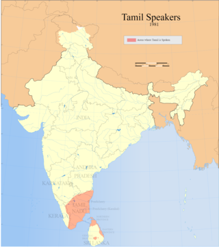
Tamil South Africans are South Africans of Tamil descent. Tamil people form the majority of Indian immigrants who came from India to Natal, South Africa, from 1860 onwards. After the expiry of their indentures most of these Indians moved to the cities, becoming established as a thoroughly urban population.
Drummond may refer to:
Ladismith is a town and agricultural centre in the western Klein Karoo region of South Africa's Western Cape province. In 1852 the farm Elandsvlei was set aside for the town, and it became a municipality in 1862. It was named after Lady Juana María Smith, the wife of Sir Harry Smith, one of two towns in South Africa named after her, the other being Ladysmith in KwaZulu-Natal.
Dalton is a village in 11 kilometres (6.8 mi) east of New Hanover and 35 kilometres (22 mi) south of Greytown in the uMshwati Local Municipality of KwaZulu-Natal, South Africa
Maphumulo Local Municipality is an administrative area in the iLembe District of KwaZulu-Natal in South Africa. Maphumulo is an isiZulu name meaning "place of rest".
Dannhauser Local Municipality is an administrative area in the Amajuba District of KwaZulu-Natal in South Africa. The municipality is named after Renier Dannhauser, a German settler who in 1872 purchased four farms in the area from the then owner, the Natal government.
Umzimkhulu Local Municipality is an administrative area in the Harry Gwala District of KwaZulu-Natal in South Africa. Umzimkhulu is an isiXhosa and an isiZulu name meaning “Big/Great house”.
eDumbe Local Municipality is an administrative area in the Zululand District of KwaZulu-Natal in South Africa. The municipality is named after the Dumbe mountain.
Greater Kokstad Local Municipality is an administrative area in the Harry Gwala District of KwaZulu-Natal in South Africa. Kokstad is derived from Dutch, and it means "town of Kok". It was named after Adam Kok III.
uMuziwabantu Local Municipality is an administrative area in the Ugu District of KwaZulu-Natal in South Africa.
Umzumbe Local Municipality is an administrative area in the Ugu District of KwaZulu-Natal in South Africa.
Nquthu Local Municipality is an administrative area in the Umzinyathi District of KwaZulu-Natal in South Africa. Nquthu is an isiZulu name meaning "the back of the head".
Mkhambathini Local Municipality is an administrative area in the UMgungundlovu District of KwaZulu-Natal in South Africa. Mkhabathini is the isiZulu name derived from the Zulu word eMkhambathini meaning the place of acacia trees.
Umvoti Local Municipality is an administrative area in the Umzinyathi District of KwaZulu-Natal in South Africa.
The Natal Railway 0-4-0WTNatal of 1860 was a South African steam locomotive from the pre-Union era in the Natal Colony.
The South African Railways Class 8B 4-8-0 of 1903 was a steam locomotive from the pre-Union era in Transvaal Colony.
KZN Literary Tourism is a literary tourism research project initiated in 2002 by Professor Lindy Stiebel, a lecturer in the English Studies department at the University of KwaZulu-Natal. The project has created an online archive of over a 100 writers linked to the KwaZulu-Natal province, collected reviews of local literature, conducted interviews of local authors, promoted local literary events such as Time of the Writer and investigated “the links between literature and tourism in scholarly colloquia and publications”. The project has also been responsible for creating eight writer trails which attempt to connect writers, their works and place within the province.
This KwaZulu-Natal location article is a stub. You can help Wikipedia by expanding it. |