Glenoma, Washington

Last updated

Glenoma, Washington
USA Washington location map.svg
Red pog.svg
Glenoma
Usa edcp location map.svg
Red pog.svg
Glenoma
Coordinates: 46°30′52″N122°09′36″W / 46.51444°N 122.16000°W / 46.51444; -122.16000
Country United States
State Washington
County Lewis
Elevation
[1] 820 ft (250 m)
Time zone UTC-8 (Pacific (PST))
  Summer (DST) UTC-7 (PDT)
ZIP code
98336
Area code 360

Glenoma is an unincorporated community in Lewis County located off U.S. Route 12, between the towns of Morton and Randle. The area is northeast of Riffe Lake. [1]

Contents

History

Glenoma was originally named Vern and briefly as Verndale. [1] The area was later renamed by Beverly Coiner, deriving the moniker by combining glen, meaning "valley", and oma, from the Hebrew word for "a measure of grain"; the name was construed to mean "fruitful valley". [2] [3] [4]

The first covered swimming pool in Lewis County opened in Glenoma in 1961. [5]

Climate

According to the Köppen Climate Classification system, Glenoma has a warm-summer Mediterranean climate, abbreviated "Csb" on climate maps. [6]

Climate data for Glenoma
MonthJanFebMarAprMayJunJulAugSepOctNovDecYear
Mean daily maximum °F (°C)44.9
(7.2)
49.9
(9.9)
53.6
(12.0)
58.6
(14.8)
65.3
(18.5)
71
(22)
77.1
(25.1)
77.9
(25.5)
72.4
(22.4)
62.1
(16.7)
51.0
(10.6)
45.1
(7.3)
60.7
(15.9)
Mean daily minimum °F (°C)31
(−1)
32.2
(0.1)
34.3
(1.3)
37
(3)
42.3
(5.7)
47
(8)
49.8
(9.9)
49
(9)
44.8
(7.1)
38.3
(3.5)
34.9
(1.6)
31.5
(−0.3)
39.3
(4.1)
Average precipitation inches (mm)10.00
(254)
6.96
(177)
6.42
(163)
5.42
(138)
3.82
(97)
2.98
(76)
1.18
(30)
1.41
(36)
3.25
(83)
5.14
(131)
9.51
(242)
10.08
(256)
66.17
(1,681)
Average snowfall inches (cm)7.7
(20)
3.5
(8.9)
1.0
(2.5)
0.3
(0.76)
0
(0)
0
(0)
0
(0)
0
(0)
0
(0)
0
(0)
1.3
(3.3)
3.2
(8.1)
16.9
(43)
Source: [7]

Parks and recreation

The community is located north of several recreation areas, including Riffe Lake, Taidnapam Park, and Cowlitz Falls Park which is located on the Cispus River near its junction to the reservoir, Lake Scanewa. [8] A 34-acre (14 ha) recreation area, known as Frost Creek Park, was first begun in the mid-1970s and was renamed Glenoma County (Community) Park. [9] [10]

Education

Students in the town are served by the White Pass School District. [11]

The Glenoma Elementary school was built in the 1920s. [lower-alpha 1] It was rebuilt after a fire in 1932 [12] and razed in 2011 after it had been closed due to low enrollment. Elementary students in the area began attending Randle Elementary School in 2004. [13]

Notes

  1. There are multiple reports recording 1923, 1929, or 1932 as to year the building was constructed. The building is reliably reported as burning down and being rebuilt in 1932.

Related Research Articles

<span class="mw-page-title-main">Lewis County, Washington</span> County in Washington, United States

Lewis County is a county in the U.S. state of Washington. As of the 2020 census, the county's population was 82,149. The county seat is Chehalis, and its largest city is Centralia. Lewis County comprises the Centralia, WA Micropolitan Statistical Area, which is also included in the Seattle-Tacoma, WA Combined Statistical Area.

<span class="mw-page-title-main">Chehalis, Washington</span> City in Washington, United States

Chehalis is a city in and the county seat of Lewis County, Washington, United States. The population was 7,439 at the time of the 2020 census.

<span class="mw-page-title-main">Morton, Washington</span> City in Washington, United States

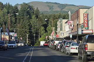
Morton is a city in Lewis County, Washington, United States. The population was 1,036 at the 2020 census.

<span class="mw-page-title-main">Cowlitz River</span> River in Washington, United States

The Cowlitz River is a river in the state of Washington in the United States, a tributary of the Columbia River. Its tributaries drain a large region including the slopes of Mount Rainier, Mount Adams, and Mount St. Helens.

Randle is a small town in eastern Lewis County, Washington, United States. Randle is located on U.S. Route 12 and is notable as the northeastern access point to the Mount St. Helens Windy Ridge viewpoint, by way of forest service roads that cut through the Gifford Pinchot National Forest.

Onalaska is an unincorporated community and census-designated place (CDP) in Lewis County, Washington, United States. As of the 2020 census it had a population of 657. Onalaska is located along Washington State Route 508.

<span class="mw-page-title-main">Packwood, Washington</span> Census-designated place in Washington, United States

Packwood is an unincorporated community and census-designated place (CDP) located in easternmost Lewis County, Washington, in the United States. As of the 2020 census, the CDP had a population of 319, while the town and surrounding Packwood community had a total population of 1,073.

<span class="mw-page-title-main">Cispus River</span> River in Washington, United States

The Cispus River is about 54 miles (87 km) long and flows into the Cowlitz River at Lake Scanewa in the Cascade Range of Washington. Its tributaries drain most of south-central and southeastern Lewis County, extreme northeast Skamania County, and some of western Yakima County.

Doty, Washington is an unincorporated community located 1.3-miles directly west of Dryad and 5 miles east of Pe Ell on Washington State Route 6. As of 2023, approximately 250 people reside in or around Doty, which boasts a general store, post office, fire department, and two churches. Logging and farming are the industries that most of the residents rely on for income.

<span class="mw-page-title-main">Evaline, Washington</span> Unincorporated community in Washington, United States

Evaline is an unincorporated community in Washington, United States, south of Napavine and 3 miles north of Winlock on State Route 603.

<span class="mw-page-title-main">Mineral, Washington</span> Census-designated place in Washington, United States

Mineral is an unincorporated community and census-designated place (CDP) in Lewis County, Washington, on State Route 7 near the Pierce/Lewis county line. Mineral originally began as a logging camp and mining town. Prospectors searching the area for gold instead found coal and arsenic. By the early 1920s, the mines closed, and with a devastating fire to the town's largest sawmill, Mineral began to turn to tourism as its main industry, primarily through recreational fishing on Mineral Lake. The population was 193 at the 2020 census, down from 202 at the 2010 census.

<span class="mw-page-title-main">Kosmos, Washington</span> Flooded town

Kosmos was an unincorporated community in Lewis County, Washington, southwest of Glenoma and is now considered a flooded town. Kosmos is named from a Greek term meaning "the world or universe as an embodiment of order and harmony".

<span class="mw-page-title-main">Riffe Lake</span> Reservoir in Washington, United States

Riffe Lake is a long reservoir on the Cowlitz River in the U.S. state of Washington. The 23.5 mi (38 km) lake was created by the construction of Mossyrock Dam, the tallest dam in the state, in 1968 by Tacoma City Light.

The White Pass School District is a school located in East Lewis County, Washington. It serves the communities of Packwood, Randle, and Glenoma which are located along US Highway 12. The district currently has a student population of around 500 students. The district and schools are named after the mountain pass over the crest of the Cascade Mountains, located at the east end of the district.

<span class="mw-page-title-main">Cowlitz Falls Dam</span> Dam in Lewis County, Washington

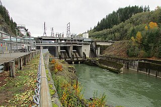
Cowlitz Falls Dam is a 70 megawatt hydroelectric dam in Lewis County, Washington. It was constructed in the early 1990s and completed in 1994. The dam is 140 feet (43 m) high and 700 feet (210 m) wide.

Forest is an unincorporated community in Lewis County, in the U.S. state of Washington. It is located on Jackson Highway, between the Port of Chehalis and Washington State Route 508.

Mayfield is an unincorporated community on the southern shore of Lake Mayfield in Lewis County, Washington. It is located off U.S. Route 12, east of Silver Creek. The Mayfield Dam, which supplies hydroelectricity to Tacoma and its neighboring cities, sits 1-mile west of the area.

Swofford, also known as Swofford Valley, is an unincorporated community in central Lewis County, in the U.S. state of Washington. The town sits on the south shore of Riffe Lake, approximately 4.0 miles (6.4 km) southeast of Mossyrock.

Wildwood is an unincorporated community in Lewis County, in the U.S. state of Washington. The town is located between Boistfort and Vader. The community's early days, similar to other areas in Lewis County, had an economy driven by lumber production however it has retained its predominant agricultural roots. The area is known for its elk hunting.

Wilson, also known as Wilson Village, is an unincorporated community located in Lewis County, Washington. The former town is in a rural area in the mid-south region of the county, south of Winston and 7.0 miles (11.3 km) south of Mayfield. Communities and towns around Riffe Lake are 12.0 miles (19.3 km) to the northeast of the area. Wilson is mostly residential in nature.

References

  1. 1 2 3 "Glenoma". Geographic Names Information System . United States Geological Survey, United States Department of the Interior.
  2. Meany, Edmond S. "Origin of Washington geographic names". University of Washington press. Archived from the original on December 12, 2021. Retrieved December 13, 2021.
  3. Majors, Harry M. (1975). Exploring Washington. Van Winkle Publishing Co. p. 122. ISBN   978-0-918664-00-6. Archived from the original on February 3, 2023. Retrieved October 15, 2016.
  4. Meany, Edmond S. (1923). Origin of Washington geographic names. Seattle: University of Washington Press. p. 97. Archived from the original on November 23, 2023. Retrieved August 2, 2016.
  5. The Chronicle Staff (May 30, 2014). "Today in Lewis County History: Band Upsets Animals; Salkum Mill Reopens; East Lewis County Pool Opens; Fire Causes $6 Million Damage". The Chronicle. Archived from the original on December 13, 2021. Retrieved December 13, 2021.
  6. "Climate Summary for Glenoma, Washington". Archived from the original on November 7, 2021. Retrieved November 7, 2021.
  7. "GLENOMA, WASHINGTON (453177)". Western Regional Climate Center. Archived from the original on November 7, 2021. Retrieved November 7, 2021.
  8. Rose, Buddy (October 29, 2004). "Coho bring anglers to Lake Scanewa". The Chronicle (Centralia, Washington) . Archived from the original on February 7, 2024. Retrieved February 7, 2024.
  9. "Work begins on park". The Daily Chronicle. October 3, 1975. p. 1. Retrieved June 11, 2024.
  10. "County parks scattered through region". The Chronicle. May 26, 1994. p. 22. Retrieved June 11, 2024.
  11. "White Pass School District". whitepass.k12.wa.us. White Pass School District. Archived from the original on December 13, 2021. Retrieved December 13, 2021.
  12. Mittge, Brian (January 24, 2007). "Rampage in Pe Ell Earns Murder Conviction in 1907". The Chronicle. Archived from the original on December 13, 2021. Retrieved December 13, 2021.
  13. Pesanti, Dameon (May 22, 2014). "Residents Reviving Community History in Glenoma". The Chronicle. Archived from the original on December 13, 2021. Retrieved December 13, 2021.