
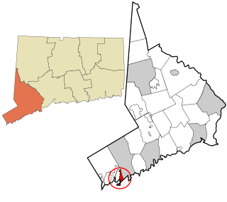
Greenwich is a town in southwestern Fairfield County, Connecticut, United States. As of the 2010 census, the town had a total population of 61,171, with a census-estimated increase of 62,574 in 2018. The largest town on Connecticut's Gold Coast, Greenwich is home to many hedge funds and other financial service firms. Greenwich is a principal community of the Bridgeport–Stamford–Norwalk–Danbury metropolitan statistical area, which comprises all of Fairfield County.
Mianus, formerly Mayamus and Upper Landing, is a neighborhood in the town of Greenwich in the U.S. state of Connecticut. Unlike other Greenwich neighborhoods such as Cos Cob or Old Greenwich, Mianus does not have its own ZIP code or post office. Mianus lies partly in the Cos Cob ZIP code, partly in the Riverside ZIP code area, and partly in the Old Greenwich ZIP code area. It lies at an elevation of 23 feet and is home to an elementary school. Mianus was also home to the Mianus Motor Works, a marine-engine manufacturer.
Cos Cob is a neighborhood and census-designated place in the town of Greenwich, Connecticut. It is located at 41.033 north, 73.6 west, on the Connecticut shoreline in southern Fairfield County. It had a population of 6,770 at the 2010 census.

Byram is a neighborhood/section and census-designated place (CDP) in the town of Greenwich in Fairfield County, Connecticut, United States. It had a population of 4,146 at the 2010 census, and a census-estimated population of 4,216 in 2018. An endcap of Connecticut's Gold Coast, Byram is the southernmost point in the town of Greenwich and the U.S. state of Connecticut. It is separated from Port Chester, Westchester County, New York, by the Byram River. Byram was once known as East Port Chester.

Gales Ferry is a village in the town of Ledyard, Connecticut, United States. It is located along the eastern bank of the Thames River. The village developed as a result of having a ferry to Uncasville located at this site, and from which the village was named. Gales Ferry was listed as a census-designated place for the 2010 Census, with a population of 1,162.

The history of Greenwich, Connecticut.
Greenwich Public Schools is a school district located in Fairfield County, in Greenwich, Connecticut. The district has boundaries that are coterminous with those of the town. Approximately 8,840 students, grades K–12, attend the Greenwich Public Schools.

The Greenwich Council of the Boy Scouts of America was founded in 1912. Its headquarters resides at 63 Mason Street in Greenwich, Connecticut.

Riverside is a neighborhood/section in the town of Greenwich in Fairfield County, Connecticut, United States. As of the 2010 census, it had a population of 8,416.
Old Greenwich is a coastal neighborhood/section and census-designated place in Greenwich in Fairfield County, Connecticut, United States, and is among America's wealthiest communities. As of the 2010 census it had a population of 6,611.

Glenville Historic District, also known as Sherwood's Bridge, is a 33.9 acres (13.7 ha) historic district in the Glenville neighborhood of the town of Greenwich, Connecticut. It is the "most comprehensive example of a New England mill village within the Town of Greenwich". It "is also historically significant as one of the town's major staging areas of immigrants, predominantly Irish in the 19th century and Polish in the 20th century" and remains "the primary settlement of Poles in the town". Further, "[t]he district is architecturally significant because it contains two elaborate examples of mill construction, designed in the Romanesque Revival and a transitional Stick-style/Queen Anne; an excellent example of a Georgian Revival school; and notable examples of domestic and commercial architecture, including a Queen Anne mansion and an Italianate store building."

The Glenville School is a historic school building at 449 Pemberwick Road in the Glenville section of Greenwich, Connecticut, United States. It was listed on the National Register of Historic Places in 2003. It was one of several schools built in the town in the 1920s, when it consolidated its former rural school districts into a modern school system, with modern buildings.

The Byram School is a historic former school building, located between Sherman Avenue and Western Junior Highway in Greenwich, Connecticut. Completed in 1926, it is a well-preserved example of institutional Colonial Revival architecture, enhanced by a parklike setting. It was used as a school until 1978, and was then converted to senior housing. The building was listed on the National Register of Historic Places on August 2, 1990.
The New Mill and Depot Building of the former Hawthorne Woolen Mill are located in Greenwich, Connecticut, United States. The two structures were built on an existing textile mill complex in the 1870s.

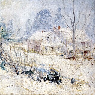
The Strickland Road Historic District of Greenwich, Connecticut is a 9-acre (3.6 ha) historic district that was listed on the U.S. National Register of Historic Places in 1990. The district extends along Strickland Road in the Cos Cob section of Greenwich, between its junction River Road in the south, to just north of its junction with Loughlin Road in the north. It represents a well-preserved cross-section of residential architecture dating coverint a 200-year period, from about 1740 to 1934. It includes the c. 1730 Bush-Holley House, a historic house museum which is a National Historic Landmark for it role in the Cos Cob art colony. There are 28 primary contributing buildings in the district. Most of the buildings are wood frame structures between one and three stories in height; the notable exceptions are two of the later houses, which are Tudor Revival in style and have brick and stucco exteriors.

Pemberwick is a neighborhood/section and census-designated place in Greenwich in Fairfield County, Connecticut, United States. As of the 2010 census it had a population of 3,680.
This is a list of the National Register of Historic Places listings in Greenwich, Connecticut.
Greenwich is a census-designated place (CDP) in Fairfield County, Connecticut, United States. It is one of several CDPs within the town of Greenwich and corresponds to the historic municipal center of the town and surrounding residential and commercial areas. As of the 2010 census, the population of the Greenwich CDP was 12,942, out of 61,171 in the entire town.
Greenwich Library is the main library in the Greenwich library system of Greenwich, Connecticut, United States. The Greenwich Library system consists of the Main Library and its Byram Shubert and Cos Cob branches.

The Gold Coast, also known as Lower Fairfield County or Southwestern Connecticut not limited to the Connecticut Panhandle, is an affluent part of Western Connecticut that includes the entire southern portion of Fairfield County as defined by the U.S. Census Bureau, Super-Public Use Microdata Area (Super-PUMA) Region 09600. The area is about 50 miles northeast of New York City, and is home to many wealthy Manhattan business executives. Parts of the region are served by the Western Connecticut Council of Governments.

