Gold Butte (Montana)

Last updated
Gold Butte
Gold Butte.jpg
Northwest aspect
Highest point
Elevation 6,512 ft (1,985 m) [1] [2]
Prominence 2,342 ft (714 m) [2]
Parent peak Mount Royal (6,914 ft) [2]
Isolation 9.17 mi (14.76 km) [2]
Coordinates 48°50′53″N111°22′30″W / 48.8481743°N 111.3749715°W / 48.8481743; -111.3749715 [3]
Geography
USA Montana relief location map.jpg
Red triangle with thick white border.svg
Gold Butte
Location in Montana
Usa edcp relief location map.png
Red triangle with thick white border.svg
Gold Butte
Location in the United States
CountryUnited States
State Montana
County Toole
Parent range Sweet Grass Hills [1]
Topo map USGS Grassy Butte
Geology
Age of rock Eocene
Mountain type Laccolith
Type of rock Igneous rock (Diorite)
Climbing
Easiest route class 2

Gold Butte is a 6,512-foot (1,985-metre) mountain summit located in Toole County, Montana, United States. [3]

Contents

Description

Gold Butte is part of the Sweet Grass Hills and ranks as the fourth-highest peak in the range, [1] and second-highest in the county. [2] It is situated 32 miles (51 km) northeast of Shelby, Montana, and 10 miles (16 km) south of the Canada–United States border, on land administered by the Bureau of Land Management. [4] Precipitation runoff from the mountain drains south to the Marias River and north to the Milk River. [1] Topographic relief is significant as the summit rises over 2,400 feet (730 meters) above the surrounding plains in less than two miles.

Gold Butte Gold Butte - Flickr - pellaea.jpg
Gold Butte

Geology

Gold Butte is an exposed laccolith composed of diorite porphyry which was created by an igneous intrusion through older Cretaceous sedimentary rocks during the Eocene, about 50 million years ago. [4] [5] Dikes and sills radiate across the conical mass. Over time, erosion of the sedimentary rock has exposed the solidified laccolith which is more resistant to weathering. Minor amounts of gold and silver were produced by placer mining in a gulch on the north slope during the late-19th and early-20th centuries. [4] The yield was likely less than 2,000 ounces of gold. [5]

History

The Sweet Grass Hills are sacred to the Blackfoot and other tribes. [6] Mountain Chief, Calf Tail, and Bull Lodge experienced their respective vision quests on Gold Butte. [5] The ghost town of "Gold Butte" was a gold-mining camp located on the mountain's northwest slope after gold was discovered here in 1884. [7] [8] The landform's toponym has been officially adopted by the United States Board on Geographic Names. [3]

Climate

Based on the Köppen climate classification, Gold Butte is located in a semi-arid climate zone with long, cold, dry winters and hot summers with cool nights. [5] [9] Winter temperatures can drop below −10 °F with wind chill factors below −30 °F.

See also

Related Research Articles

<span class="mw-page-title-main">Toole County, Montana</span> County in Montana, United States

Toole County is a county in the northern portion of the U.S. state of Montana. As of the 2020 census, the population was 4,971. Its county seat is Shelby. The county was established in 1914 from parts of Hill County and Teton County and was named after Joseph Toole, the first and fourth governor of Montana. Its northern boundary is the Canada–United States border south of Alberta.

<span class="mw-page-title-main">Bear Butte</span> United States historic place

Bear Butte is a geological laccolith feature located near Sturgis, South Dakota, United States, that was established as a State Park in 1961. An important landmark and religious site for the Plains Indians tribes long before Europeans reached South Dakota, Bear Butte is called Matȟó Pahá, or Bear Mountain, by the Lakota, or Sioux. To the Cheyenne, it is known as Noahȧ-vose or Náhkȯhe-vose, and is the place where Ma'heo'o imparted to Sweet Medicine, a Cheyenne prophet, the knowledge from which the Cheyenne derive their religious, political, social, and economic customs.

<span class="mw-page-title-main">Sweet Grass, Montana</span> Census-designated place in Montana, United States, along the Canadian border

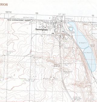
Sweet Grass is a census-designated place and unincorporated community in Toole County, Montana, United States, on the Canada–US border. It is the northern terminus of Interstate 15, an important route connecting western Canada, the western United States, and Mexico. The population was 65 according to the 2020 census.

<span class="mw-page-title-main">Geography of North Dakota</span>

The Geography of North Dakota consists of three major geographic regions: in the east is the Red River Valley, west of this, the Missouri Plateau. The southwestern part of North Dakota is covered by the Great Plains, accentuated by the Badlands. There is also much in the way of geology and hydrology.

<span class="mw-page-title-main">Crested Butte</span> Mountain in the state of Colorado

Crested Butte is a prominent mountain summit in the Elk Mountains range of the Rocky Mountains of North America. The 12,168-foot (3,709 m) peak is in Gunnison National Forest, 2.1 miles (3.4 km) northeast by east of the Town of Crested Butte in Gunnison County, Colorado, United States. Ski lifts and runs of the Crested Butte Mountain Resort occupy the north side of the mountain.

Bearmouth was a trading post for the placer mining camps of Beartown, Garnet and Coloma, located in the hills north of Bearmouth in Granite County, Montana, United States. A pioneer family named Lannen operated the gold exchange and ferry boat across the Clark Fork River.

<span class="mw-page-title-main">Black Hills</span> Mountain range in South Dakota and Wyoming

The Black Hills is an isolated mountain range rising from the Great Plains of North America in western South Dakota and extending into Wyoming, United States. Black Elk Peak, which rises to 7,244 feet (2,208 m), is the range's highest summit. The Black Hills encompass the Black Hills National Forest. The name of the hills in Lakota is Pahá Sápa. The Black Hills are considered a holy site. The hills are so called because of their dark appearance from a distance, as they are covered in evergreen trees.

<span class="mw-page-title-main">Bishops Cap</span>

Bishops Cap is located in the Lewis Range, Glacier National Park in the U.S. state of Montana. Located above the Garden Wall and straddling the Continental Divide, when viewed from the south at Logan Pass, the peak appears to resemble a Bishop's headwear. The name Bishops Cap is descriptive only, and there's no known origin.

<span class="mw-page-title-main">Sweet Grass Hills</span>

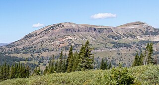
The Sweet Grass Hills are a small group of low mountains rising more than 3,000 feet (910 m) above the surrounding plains southwest of Whitlash, Montana, in Liberty and Toole County, Montana. The tallest point in the hills is West Butte at 6,983 feet (2,128 m). Quite prominent in the local area, they are clearly visible from US Highway 2 to the south, I-15, and can sometimes be seen as far North as the Crowsnest Highway (Highway 3) near Medicine Hat in Alberta as well as from the West, near Glacier National Park and Browning, Montana. Visibility may vary depending on local air temperatures or heat domes that may increase or decrease the apparent height of the features. Other named peaks in the small group are Gold Butte (6,512 ft [1,985 m]), East Butte, and Mount Lebanon (5,807 ft [1,770 m]). The Sweet Grass Hills are an example of the island ranges that dot the central third portion of the state of Montana. These island ranges, completely surrounded by the 'sea' of plains and not geographically part of the Rocky Mountains to the west, are "biological hotspots", containing more species than the prairie below.

<span class="mw-page-title-main">Mount Phillips (Montana)</span> Mountain in the state of Montana

Mount Phillips is located in the Lewis Range, Glacier National Park in the U.S. state of Montana. Lupfer Glacier is located on the east slope of Mount Phillips.

<span class="mw-page-title-main">Regional designations of Montana</span> Overview of the Regional designations of Montana

The Regional designations of Montana vary widely within the U.S state of Montana. The state is a large geographical area that is split by the Continental Divide, resulting in watersheds draining into the Pacific Ocean, Gulf of Mexico and Hudson's Bay. The state is approximately 545 miles (877 km) east to west along the Canada–United States border and 320 miles (510 km) north to south. The fourth largest state in land area, it has been divided up in official and unofficial ways into a variety of regions. Additionally, Montana is part of a number of larger federal government administrative regions.

<span class="mw-page-title-main">East Beckwith Mountain</span> Mountain in Colorado, United States

East Beckwith Mountain is a prominent mountain summit in the West Elk Mountains range of the Rocky Mountains of North America. The 12,441-foot (3,792 m) peak is located in the West Elk Wilderness of Gunnison National Forest, 13.4 miles (21.5 km) west by south of the Town of Crested Butte in Gunnison County, Colorado, United States.

<span class="mw-page-title-main">Carbon Peak</span> Mountain in Colorado, United States

Carbon Peak, elevation 12,088 ft (3,684 m), is a summit in the West Elk Mountains of Colorado. The peak is southwest of Crested Butte in the Gunnison National Forest. Carbon Peak is one of several prominent laccoliths found in the West Elk Mountains.

<span class="mw-page-title-main">West Beckwith Mountain</span> Mountain in Colorado, USA

West Beckwith Mountain is a prominent mountain summit in the West Elk Mountains range of the Rocky Mountains of North America. The 12,185-foot (3,714 m) peak is located in the West Elk Wilderness of Gunnison National Forest, about 16.5 miles (26.5 km) southwest of Crested Butte in Gunnison County, Colorado, United States.

<span class="mw-page-title-main">Mount Pennell</span> Mountain summit in Utah

Mount Pennell is a prominent 11,413-foot elevation summit located in eastern Garfield County, Utah, United States. Mount Pennell is the second-highest mountain in the Henry Mountains, following Mount Ellen, 10.6 miles to the north. It is situated in a dry, rugged, and sparsely settled region east of Capitol Reef National Park, on primitive land administered by the Bureau of Land Management. Several deep canyons cut the sides of the mountain, which on the higher slopes supports oak, Ponderosa pine, subalpine fir, spruce, Douglas fir, and aspen. Precipitation runoff from this mountain drains into tributaries of the nearby Colorado River.

<span class="mw-page-title-main">Haystack Butte</span> Mountain in the state of Montana

Haystack Butte is a 7,486-foot-elevation (2,282-meter) summit located in the Lewis Range, of Glacier National Park in the U.S. state of Montana. It is situated one mile west of the Continental Divide, in Flathead County, above the Weeping Wall on its south slope. Topographic relief is significant as the west aspect rises 3,900 feet above McDonald Creek in less than 1.5 mile. It can be seen from Logan Pass, and from Going-to-the-Sun Road which traverses the west and south slopes of the peak. The nearest higher neighbor is Mount Gould, 1.07 miles (1.72 km) to the northeast. Climbing access is via the Highline Trail. This geographical feature's descriptive name was on maps as early as 1904, and was officially adopted March 6, 1929, by the United States Board on Geographic Names

<span class="mw-page-title-main">Mount Logan (Garfield County, Colorado)</span>

Mount Logan is an 8,413-foot-elevation (2,564-meter) mountain summit located in Garfield County, Colorado, United States. This peak is situated 5 miles (8.0 km) north of the community of De Beque, and 31 miles (50 km) northeast of Grand Junction. Interstate 70 traverses the southeast base of the mountain. Precipitation runoff from this landform drains into the Colorado River, and topographic relief is significant as the summit rises 3,500 feet above the river in three miles (4.8 km). The mountain and surrounding area is controlled by the Bureau of Land Management. This landform's toponym has appeared in publications since at least 1913, and has been officially adopted by the U.S. Board on Geographic Names.

<span class="mw-page-title-main">Mount Lebanon (Montana)</span>

Mount Lebanon is a 5,807-foot (1,770-metre) mountain summit in Liberty County, Montana, United States.

<span class="mw-page-title-main">West Butte (Montana)</span>

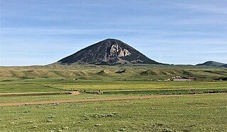
West Butte is a 6,983-foot-elevation (2,128-meter) mountain summit located in Toole County, Montana, United States.

<span class="mw-page-title-main">Mount Brown (Liberty County, Montana)</span> Mountain in Liberty County, Montana, United States

Mount Brown is a 6,958-foot-elevation (2,121-meter) mountain summit located in Liberty County, Montana, United States.

References

  1. 1 2 3 4 "Gold Butte, Montana". Peakbagger.com. Retrieved 2023-07-22.
  2. 1 2 3 4 5 "Gold Butte - 6,512' MT". listsofjohn.com. Retrieved 2023-07-22.
  3. 1 2 3 "Gold Butte". Geographic Names Information System . United States Geological Survey, United States Department of the Interior . Retrieved 2023-07-22.
  4. 1 2 3 Sweet Grass Hills, blm.gov, Retrieved 2023-07-22.
  5. 1 2 3 4 Sweet Grass Hills Resource(s) Management Plan (RMP) Amendment and West HiLine Resource(s) Management Plan (RMP), Toole County, Liberty County: Environmental Impact Statement, 1996, p. 13, 19.
  6. Rich Aarstad, Montana Place Names from Alzada to Zortman, Montana Historical Society, 2009, ISBN   9780975919613, p. 259.
  7. Jerry Grant (2020), Grants Mining Districts of the Western United States: Volume 2, Xlibris Corporation, ISBN   9781664149021
  8. "Gold Butte". Geographic Names Information System . United States Geological Survey, United States Department of the Interior . Retrieved 2023-07-22.
  9. Peel, M. C.; Finlayson, B. L.; McMahon, T. A. (2007). "Updated world map of the Köppen−Geiger climate classification". Hydrol. Earth Syst. Sci. 11. ISSN   1027-5606.