Gold Rush (music festival)

Last updated
Gold Rush
Goldrushfestival.jpg
Genre Rock, folk, soul, blues
DatesOctober 4–5, 1969
Location(s) Amador County, California
Years active1969
Attendance40,000-50,000

Gold Rush was a music festival held at Lake Amador in Amador County, California on October 4, 1969. [1] The festival was sponsored and promoted by music manager Robert Strand, disc jockey Gene Lane, and professor James Davis. [2] [3]

Contents

Overview

There were concerns that the festival would cause a disruption in the area. Residents of the nearby cities Ione, California and Jackson, California were "shook up' about the prospects of hosting hordes of rock music enthusiasts." [4] According to The Sun-Telegram , "one county official wanted to short circuit the festival by cutting off the electricity to the site, but he was overruled by the board for supervisors." [4]

Dr. James Davis, a professor of botany at San Joaquin Delta College in Stockton, California, and his students built a bandstand and concession both to be used for the festival. [2] The proceeds of the festival went to Project Costa Rica, a nonprofit education venture headed by Dr. David. He took his students to Costa Rica each year for science research projects. [5]

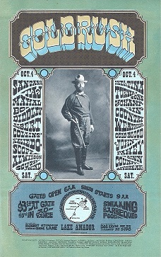
Davis named the festival "Gold Rush" after the gold mining past of Amador County. [6]

Although drugs were prevalent and some concertgoers went skinny dipping in the lake, no arrests were made. Amador County officials said the thousands of people, many of whom had camped out for days, were "completely peaceful and law-abiding." [7]

Tickets for the event cost $3 in advance and $3.50 at the gate. [1] An estimated 40,000-50,000 people attended the festival which was held at a 40-acre site near Lake Amador. [8] [7] The music began at 9 a.m. on Saturday, October 4, and ended at 2 a.m. on Sunday, October 5. [9] Davis estimated that the festival grossed only $32,450 due to greedy gate guards and dishonest people posing as ticket takers. [10]

Performers

The event was advertised as a rock music festival but there were blues, soul, and folk musicians in the lineup as well. [11]

List of performers:

See also

Related Research Articles

<span class="mw-page-title-main">Sacramento, California</span> Capital city of California, United States

Sacramento is the capital city of the U.S. state of California and the county seat of Sacramento County. Located at the confluence of the Sacramento and American Rivers in Northern California's Sacramento Valley, Sacramento's 2020 population of 524,943 makes it the fourth-most populous city in Northern California, sixth-most populous city in the state, and the ninth-most populous state capital in the United States. Sacramento is the seat of the California Legislature and the Governor of California.

<span class="mw-page-title-main">Amador County, California</span> County in California, United States

Amador County is a county located in the U.S. state of California, in the Sierra Nevada. As of the 2020 census, the population was 40,474. The county seat is Jackson. Amador County, located within California's Gold Country, is known as "The Heart of the Mother Lode". There is a substantial viticultural industry in the county.

<span class="mw-page-title-main">Stockton, California</span> City in California, United States

Stockton is a city in and the county seat of San Joaquin County in the Central Valley of the U.S. state of California. Stockton is the largest city in the county, the 11th largest city in California and the 58th largest city in the United States. Stockton's population in 2020 was 320,804. It was named an All-America City in 1999, 2004, 2015, and again in 2017. The city is located on the San Joaquin River in the northern San Joaquin Valley. It lies at the southeastern corner of a large inland river delta that isolates it from other nearby cities such as Sacramento and those of the San Francisco Bay Area.

<span class="mw-page-title-main">Northern California</span> American geographic and cultural region

Northern California is a geographic and cultural region that generally comprises the northern portion of the U.S. state of California. Spanning the state's northernmost 48 counties, its main population centers include the San Francisco Bay Area, the Greater Sacramento area, the Redding, California, area south of the Cascade Range, and the Metropolitan Fresno area. Northern California also contains redwood forests, along with most of the Sierra Nevada, including Yosemite Valley and part of Lake Tahoe, Mount Shasta, and most of the Central Valley, one of the world's most productive agricultural regions.

<span class="mw-page-title-main">San Joaquin River</span> Longest river of Central California, United States

The San Joaquin River is the longest river of Central California. The 366-mile (589 km) long river starts in the high Sierra Nevada, and flows through the rich agricultural region of the northern San Joaquin Valley before reaching Suisun Bay, San Francisco Bay, and the Pacific Ocean. An important source of irrigation water as well as a wildlife corridor, the San Joaquin is among the most heavily dammed and diverted of California's rivers.

<i>San Joaquins</i> Amtrak service in San Joaquin Valley, California

The San Joaquins is a passenger train service operated by Amtrak in California's San Joaquin Valley. Six daily round trips run between its southern terminus at Bakersfield and Stockton, with onward service to Sacramento and Oakland.

<span class="mw-page-title-main">Altamont Corridor Express</span> Commuter rail service in California

The Altamont Corridor Express is a commuter rail service in California, connecting Stockton and San Jose during peak hours only. ACE is named for the Altamont Pass, through which it runs. Service is managed by the San Joaquin Regional Rail Commission, and operations are contracted to Herzog Transit Services. The 86-mile (138 km) route includes ten stops, with travel time about 2 hours and 12 minutes end-to-end. In 2022, the line had a ridership of 389,100, or about 1,900 per weekday as of the first quarter of 2023. ACE uses Bombardier BiLevel Coaches, MPI F40PH-3C locomotives, and Siemens Charger locomotives.

KOVR is a television station licensed to Stockton, California, United States, serving as the CBS outlet for the Sacramento area. It is owned and operated by the network's CBS News and Stations division alongside independent station KMAX-TV. Both stations share studios on KOVR Drive in West Sacramento, while KOVR's transmitter is located in Walnut Grove, California.

<span class="mw-page-title-main">California State Route 88</span> Highway in California

State Route 88 (SR 88), also known as the Carson Pass Highway, is a state highway in the U.S. state of California. It travels in an east–west direction from Stockton, in the San Joaquin Valley, to the Nevada state line, where it becomes Nevada State Route 88, eventually terminating at U.S. Route 395 (US 395). The highway is so named as it crests the Sierra Nevada at Carson Pass. The highway corridor predates the era of the automobile; the path over Carson pass was previously used for the California Trail and the Mormon Emigrant Trail. The mountainous portion of the route is included in the State Scenic Highway System.

<span class="mw-page-title-main">Area codes 209 and 350</span> Area codes in northern Central Valley, California

Area codes 209 and 350 are telephone area codes in the North American Numbering Plan (NANP) for the U.S. state of California. Their service area includes Stockton, Modesto, Turlock, Merced, Winton, Atwater, Livingston, Manteca, Ripon, Tracy, Lodi, Galt, Sonora, Los Banos, San Andreas, Mariposa, and Yosemite, the northern San Joaquin Valley, and the Sierra Foothills.

KXJZ is a non-commercial, listener-supported public radio station in Sacramento, California. It is owned by Sacramento State University and has studios on the campus at 7055 Folsom Boulevard. KXJZ's sister station is classical music-formatted KXPR 88.9 FM. The two stations are known as CapRadio.

<span class="mw-page-title-main">U.S. Route 50 in California</span> Highway in California

U.S. Route 50 (US 50) is a transcontinental United States Numbered Highway, stretching from West Sacramento, California, in the west to Ocean City, Maryland, in the east. The California portion of US 50 runs east from Interstate 80 (I-80) in West Sacramento to the Nevada state line in South Lake Tahoe. A portion in Sacramento also has the unsigned designation of Interstate 305. The western half of the highway in California is a four-or-more-lane divided highway, mostly built to freeway standards, and known as the El Dorado Freeway outside of downtown Sacramento. US 50 continues as an undivided highway with one eastbound lane and two westbound lanes until the route reaches the canyon of the South Fork American River at Riverton. The remainder of the highway, which climbs along and out of the canyon, then over the Sierra Nevada at Echo Summit and into the Lake Tahoe Basin, is primarily a two-lane road.

<span class="mw-page-title-main">Outline of California</span> Overview of and topical guide to California

The following outline is provided as an overview of and topical guide to the U.S. state of California.

Lake Amador is a reservoir located in Amador County, California. It lies at an elevation of 325 feet.

The Stockton–Los Angeles Road, also known as the Millerton Road, Stockton–Mariposa Road, Stockton–Fort Miller Road or the Stockton–Visalia Road, was established about 1853 following the discovery of gold on the Kern River in Old Tulare County. This route between Stockton and Los Angeles followed by the Stockton–Los Angeles Road is described in "Itinerary XXI. From Fort Yuma to Benicia, California", in The Prairie Traveler: A Hand-book for Overland Expeditions by Randolph Barnes Marcy. The Itinerary was derived from the report of Lieutenant R. S. Williamson on his topographical survey party in 1853, that was in search of a railroad route through the interior of California.

<span class="mw-page-title-main">California Digital Newspaper Collection</span> Online archive of digitized newspapers

The California Digital Newspaper Collection (CDNC) is a freely-available, archive of digitized California newspapers; it is accessible through the project's website. The collection contains over six million pages from over forty-two million articles. The project is part of the Center for Bibliographical Studies and Research (CBSR) at the University of California Riverside.

<span class="mw-page-title-main">Transportation in the Sacramento metropolitan area</span> Complex multi-modal network moving people and goods in the region of California’s state capital

Transportation in the Sacramento metropolitan area consists of a variety of different modes of travel in El Dorado County, Placer County, Sacramento County, and Yolo County, which are the four counties that comprise the Sacramento metropolitan area.

<span class="mw-page-title-main">Little Mandeville Island</span> Island in California

Little Mandeville Island is a small, mostly submerged island in the San Joaquin River delta, in California. It is part of San Joaquin County, and its coordinates are 38.0104776°N 121.5649522°W. In 1994, 376 acres (152 ha) of former farmland was inundated with water after a levee broke.

<span class="mw-page-title-main">Atherton Island</span> Island in California

Atherton Island is a small island in the Sacramento–San Joaquin River Delta. It is in unincorporated San Joaquin County, California, part of Stockton. Its coordinates are 37°57′22″N121°21′01″W, and the United States Geological Survey measured its elevation as 13 ft (4.0 m) in 1999. It appears on a 2015 USGS map of the area.

References

  1. 1 2 "Stage Is Set for Amador Fete". The Sacramento Bee. October 3, 1969. pp. C4.
  2. 1 2 "Concessionaire Is Warned As Rock Fete Plan Proceeds". The Sacramento Bee. September 29, 1969. pp. B1.
  3. Lynn, Canning (April 29, 2019). "1969 Amador Gold Rush Music Festival". Eagle Magazine. Retrieved 2023-09-15.
  4. 1 2 "Amador County Grids for Invasion By 'Mother Lode' Rock Festival". The Sun-Telegram. October 4, 1969. p. 16.
  5. "Huge rock benefit planned in Sierra". Oakland Tribune. September 27, 1969. p. 16.
  6. "Planners Expect 20,000 For Rock Festival Oct. 4 At Lake Amador". The Sacramento Bee. September 19, 1969. pp. B1.
  7. 1 2 Berthelsen, John (October 5, 1969). "Amador Gold Rush Music Festival Provides Holiday for Marijuana, Wine, Nudes, LSD, Rock Beat". The Sacramento Bee: A15–A18.
  8. Becker, Harley (October 5, 1969). "50,000 Jam Amador Lake Festival". Stockton Sunday Record. p. 1.
  9. Stanfield, Dick (October 5, 1969). "Weekend Rock Music Festival Leaves Amador County Reeling". The Modesto Bee. pp. B-2.
  10. Whaley Jr., Milt (October 12, 1969). "Rockfest Blues: Promoter Says Sharpies Panned the Amador Gold". Stockton Sunday Record. pp. 17-F.
  11. "1969 Gold Rush Festival | The Woodstock Whisperer/Jim Shelley". 2016-10-04. Retrieved 2023-09-15.
  12. "Tina Turner, Lake Amador Gold Rush Festival Oct. 4 1969". Merced Music. 2013-02-01. Retrieved 2023-09-15.
  13. "Lake Amador Gold Rush Festival Oct. 4 1969". Merced Music. 2013-02-12. Retrieved 2023-09-15.