You can help expand this article with text translated from the corresponding article in French. (December 2008)Click [show] for important translation instructions.
|
Grandrieux | |
|---|---|
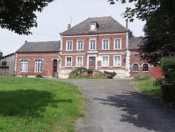 The town hall of Grandrieux | |
 Location of Grandrieux | |
 Grandrieux  Grandrieux | |
| Coordinates: 49°43′52″N4°11′08″E / 49.7311°N 4.1856°E | |
| Country | France |
| Region | Hauts-de-France |
| Department | Aisne |
| Arrondissement | Vervins |
| Canton | Vervins |
| Intercommunality | Portes de la Thiérache |
| Government | |
| • Mayor (2020–2026) | Nicole Bart [1] |
Area 1 | 4.35 km2 (1.68 sq mi) |
| Population (2023) [2] | 80 |
| • Density | 18/km2 (48/sq mi) |
| Time zone | UTC+01:00 (CET) |
| • Summer (DST) | UTC+02:00 (CEST) |
| INSEE/Postal code | 02354 /02360 |
| Elevation | 147–242 m (482–794 ft) (avg. 171 m or 561 ft) |
| 1 French Land Register data, which excludes lakes, ponds, glaciers > 1 km2 (0.386 sq mi or 247 acres) and river estuaries. | |
Grandrieux is a commune in the Aisne department in Hauts-de-France in northern France.