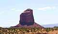
Gray Whiskers

Last updated
Gray Whiskers
Grey Whiskers Butte from Main Monument Valley Road, Oljato-Monument Valley, AZ - 53936062999.jpg
North aspect, centered
Highest point
Elevation 6,385 ft (1,946 m) [1]
Prominence 715 ft (218 m) [1]
Parent peak Mitchell Mesa (6,586 ft) [1]
Isolation 1.53 mi (2.46 km) [1]
Coordinates 36°58′07″N110°08′13″W / 36.9685415°N 110.1370799°W / 36.9685415; -110.1370799 [2]
Geography
USA Arizona relief location map.svg
Red triangle with thick white border.svg
Gray Whiskers
Location in Arizona
Usa edcp relief location map.png
Red triangle with thick white border.svg
Gray Whiskers
Gray Whiskers (the United States)
Location Navajo Reservation
Navajo County, Arizona, U.S.
Parent range Colorado Plateau
Topo map USGS Mystery Valley
Geology
Mountain type Butte
Type of rock Sandstone
Climbing
First ascent July 7, 1984, by Banditos [3]

Gray Whiskers is a 6,385-foot-elevation (1,946-meter) summit in Navajo County, Arizona, United States.

Contents

Description

Gray Whiskers is situated 1.6 miles (2.6 km) southwest of the Monument Valley visitor center on Navajo Nation land and can be seen from Highway 163. Precipitation runoff from this butte's slopes drains to Mitchell Butte Wash and Oljeto Wash which are part of the San Juan River drainage basin. Topographic relief is significant as the summit rises over 800 feet (244 meters) above the surrounding terrain in 0.15 mile (0.24 km). The nearest higher neighbor is Mitchell Mesa, 1.5 miles (2.4 km) to the east. [1] The landform's toponym has been officially adopted by the U.S. Board on Geographic Names. [2] The toponym is a translation of Navajo "dághaa' libáí" which means gray whiskers. [4] The butte is named after a Navajo Hataałii (medicine man) who was instrumental in creating the Monument Valley Tribal Park in 1958. [5] [6]

Geology

Gray Whiskers is composed of three principal strata. The bottom layer is slope-forming Organ Rock Shale, the next stratum is cliff-forming De Chelly Sandstone, and the upper layer is Moenkopi Formation. [7] The rock ranges in age from Permian at the bottom to Triassic at the top. The buttes and mesas of Monument Valley are the result of the Organ Rock Shale being more easily eroded than the overlaying sandstone. [8]

Climate

Spring and fall are the most favorable seasons to visit Gray Whiskers. According to the Köppen climate classification system, it is located in a semi-arid climate zone with cold winters and hot summers. Summers average 54 days above 90 °F (32 °C) annually, and highs rarely exceed 100 °F (38 °C). Summer nights are comfortably cool, and temperatures drop quickly after sunset. Winters are cold, but daytime highs are usually above freezing. Winter temperatures below 0 °F (−18 °C) are uncommon, though possible. This desert climate receives less than 10 inches (250 millimeters) of annual rainfall, and snowfall is generally light during the winter. [9]

See also

Related Research Articles

<span class="mw-page-title-main">Monument Valley</span> Region of the Colorado Plateau, US

Monument Valley is a region of the Colorado Plateau characterized by a cluster of sandstone buttes, with the largest reaching 1,000 ft (300 m) above the valley floor. The most famous butte formations are located in northeastern Arizona along the Utah–Arizona state line. The valley is considered sacred by the Navajo Nation, the Native American people within whose reservation it lies.

<span class="mw-page-title-main">Hunts Mesa</span> Landform in Monument Valley, US

Hunts Mesa is a rock formation located in Monument Valley, south of the border between Utah and Arizona in the United States and west of the border between Arizona's Navajo County and Apache County. It is one of two popular interior destinations in the Monument Valley Navajo Tribal Park for tourists to experience panoramic views of the popular sandstone formations from a distance. The other is Mystery Valley. A Navajo guide is required to hike to either.

<span class="mw-page-title-main">West and East Mitten Buttes</span> Buttes in Arizona, United States

The West and East Mitten Buttes are two buttes in the Monument Valley Navajo Tribal Park in northeast Navajo County, Arizona. When viewed from the south, the buttes appear to be two giant mittens with their thumbs facing inwards.

<span class="mw-page-title-main">Owl Rock</span> Landform in Navajo County, Arizona

Owl Rock is a 6,547-foot elevation sandstone summit located south of Monument Valley, in northeast Arizona. It is situated 7 miles (11 km) north of Kayenta on Navajo Nation land, and can be seen from Highway 163 perched on the east edge of Tyende Mesa, where it towers 1,000 feet above the surrounding terrain. Its nearest higher neighbor is Agathla Peak, 1.4 miles (2.3 km) to the east-northeast, on the opposite side of this highway. Precipitation runoff from this feature drains into El Capitan Wash, which is part of the San Juan River drainage basin. The first ascent of Owl Rock was made in April 1966 by Fred Beckey and Harvey Carter by climbing cracks on the west face, and then bolting up a smooth south nose to the summit. They employed 20 pitons and 14 bolts on this route called Warpath. The descriptive name stems from its uncanny resemblance to an owl when viewed from the east. This feature is known as Bee 'Adizí in Navajo language meaning "spindle", and this sacred place is considered to be a spindle left behind by the Holy People. A newer name for it is Tsé Ts'óózí, meaning "Slim Rock".

<span class="mw-page-title-main">Chimney Rock (Jackson Butte)</span> Butte in Montezuma County, Colorado, United States

Chimney Rock is a 6,110-foot (1,860 meter) elevation pillar located within the Ute Mountain Tribal Park, in Montezuma County of southwest Colorado. This landmark is situated one mile southeast of the junction of U.S. Route 491 and US 160, and towers 900 feet above the floor of the Mancos River Valley. This geographical feature is also known as Jackson Butte, named for William Henry Jackson (1843–1942), photographer and explorer famous for his images of the American West who visited this area during the Hayden Survey. He was the first to photograph the cliff dwellings in this Mesa Verde region of the Four Corners area.

<span class="mw-page-title-main">Square Butte (Arizona)</span> Landform in Coconino County, Navajo Nation, Arizona

Square Butte is a 7,140-foot-elevation (2,180 m) sandstone summit located on Navajo Nation land, in Coconino County of northern Arizona. It is situated 35 miles southeast of the town of Page, and nine miles (14 km) east of Kaibito, where it towers over 700 feet (210 m) above the surrounding terrain as a landmark alongside Arizona State Route 98. Square Butte is known as Tsé Dikʼání in Navajo language, meaning "square rock." Its nearest higher neighbor is White Mesa, two miles (3.2 km) to the south. Precipitation runoff from Square Butte drains to northwest into Square Butte Wash or northeast into Potato Canyon, then ultimately Lake Powell, all part of the Colorado River drainage basin. According to the Köppen climate classification system, Square Butte is located in an arid climate zone with hot, very dry summers, and chilly winters. Spring and fall are the most favorable seasons to visit. The top of Square Butte is composed of Entrada Sandstone including the Cow Springs Member, and it overlays Carmel Formation, all of which was deposited in the Jurassic period.

<span class="mw-page-title-main">Sentinel Mesa</span> Mountain in Utah, United States

Sentinel Mesa is a 6,450-foot-elevation (1,966-meter) summit in San Juan County, Utah, United States. It is situated 1.5 miles (2.4 km) north of the Monument Valley visitor center on Navajo Nation land and can be seen from Highway 163. The mesa is immediately northwest of the iconic West and East Mitten Buttes. The nearest higher neighbor is Brighams Tomb, 2.64 miles (4.25 km) to the north-northeast. Precipitation runoff from this mesa's west slope drains to Mitchell Butte Wash, whereas the east slope drains to West Gypsum Creek, which are both part of the San Juan River drainage basin. The "Sentinel" name refers to how the mesa oversees Monument Valley which the Navajo consider as one of the "door posts" to Monument Valley. The landform's toponym has been officially adopted by the U.S. Board on Geographic Names.

<span class="mw-page-title-main">Eagle Mesa</span> Mountain in Utah, United States

Eagle Mesa is a 6,624-foot-elevation (2,019-meter) summit in San Juan County, Utah, United States.

<span class="mw-page-title-main">Brighams Tomb</span>

Brighams Tomb is a 6,739-foot-elevation (2,054-meter) summit in San Juan County, Utah, United States.

Mitchell Mesa is a 6,586-foot-elevation (2,007-meter) summit in Navajo County, Arizona, United States.

<span class="mw-page-title-main">Spearhead Mesa</span> Mountain in Arizona, United States

Spearhead Mesa is a 5,998-foot-elevation (1,828-meter) summit in Navajo County, Arizona, United States.

<span class="mw-page-title-main">Rain God Mesa</span> Mountain in Arizona, United States

Rain God Mesa is a 5,921-foot-elevation (1,805-meter) summit in Navajo County, Arizona, United States.

<span class="mw-page-title-main">Camel Butte</span> Mountain in Arizona, United States

Camel Butte is a 5,847-foot-elevation (1,782-meter) summit in Navajo County, Arizona, United States.

<span class="mw-page-title-main">Elephant Butte (Monument Valley)</span> Mountain in Arizona, United States

Elephant Butte is a 5,981-foot-elevation (1,823-meter) summit in Navajo County, Arizona, United States.

<span class="mw-page-title-main">Cly Butte</span> Mountain in Arizona, United States

Cly Butte is a 5,820-foot-elevation (1,774-meter) summit in Navajo County, Arizona, United States.

<span class="mw-page-title-main">Setting Hen</span>

Setting Hen is a 6,293-foot-elevation (1,918-meter) summit in San Juan County, Utah, United States.

<span class="mw-page-title-main">Mitchell Butte</span> Mountain in Arizona, United States

Mitchell Butte is a 6,383-foot-elevation (1,946-meter) summit in Navajo County, Arizona, United States.

<span class="mw-page-title-main">Castle Rock (San Juan County, Utah)</span> Mountain in Utah, United States

Castle Rock is a 6,340-foot-elevation (1,932-meter) summit in San Juan County, Utah, United States.

<span class="mw-page-title-main">Big Indian (Utah)</span> Mountain in Utah, United States

Big Indian is a 6,120-foot-elevation (1,865-meter) summit in San Juan County, Utah, United States.

<span class="mw-page-title-main">Rooster Rock (Arizona)</span>

Rooster Rock is a 5,985-foot-elevation (1,824-meter) summit in Apache County, Arizona, United States.

References

  1. 1 2 3 4 5 "Gray Whiskers - 6,385' AZ". listsofjohn.com. Retrieved 2024-08-27.
  2. 1 2 "Gray Whiskers". Geographic Names Information System . United States Geological Survey, United States Department of the Interior . Retrieved 2024-08-27.
  3. First Ascent Timeline, deserttowersbook.com, Retrieved 2024-08-27.
  4. William Bright, Native American Placenames of the United States, University of Oklahoma Press, 2004, ISBN   9780806135984, p. 157.
  5. Monument Valley, City of Aztec, aztecnm.com, Retrieved 2024-08-27.
  6. Guiding tourists in Monument Valley, Los Angeles Times, July 28, 2014.
  7. Geology and Uranium-vanadium Deposits of the Monument Valley Area, Apache and Navajo Counties, Arizona, Irving Jerome Witkind, U.S. Government Printing Office, 1963, p. 139.
  8. Monument Valley, Arizona, Arizona Geological Survey, Retrieved 2024-08-27.
  9. Climate Summary for Kayenta, Arizona