Doñana National Park or Parque Nacional y Natural de Doñana is a natural reserve in Andalusia, southern Spain, in the provinces of Huelva, Cádiz and Seville. It covers 543 km2 (209.65 sq mi), of which 135 km2 (52.12 sq mi) are a protected area. It is named after Doña Ana de Silva y Mendoza, wife of the 7th Duke of Medina Sidonia.

The Guadiana River is an international river defining a long stretch of the Portugal-Spain border, separating Extremadura and Andalusia (Spain) from Alentejo and Algarve (Portugal). The river's basin extends from la Mancha and the eastern portion of Extremadura to the southern provinces of the Algarve; the river and its tributaries flow from east to west, then south through Portugal to the border towns of Vila Real de Santo António (Portugal) and Ayamonte (Spain), where it flows into the Gulf of Cádiz. With a course that covers a distance of 829 kilometres (515 mi), it is the fourth-longest in the Iberian Peninsula, and its hydrological basin extends over an area of approximately 68,000 square kilometres (26,000 sq mi).

The Guadalquivir is the fifth-longest river in the Iberian Peninsula and the second-longest river with its entire length in Spain. The Guadalquivir is the only major navigable river in Spain. Currently it is navigable from Seville to the Gulf of Cádiz, but in Roman times it was navigable from Córdoba.

Tartessos is, as defined by archaeological discoveries, a historical civilization settled in the southern Iberian Peninsula characterized by its mixture of local Paleohispanic and Phoenician traits. It had a writing system, identified as Tartessian, that includes some 97 inscriptions in a Tartessian language.

Cádiz is a province of southern Spain, in the southwestern part of the autonomous community of Andalusia. It is the southernmost part of mainland Spain, as well as the southernmost part of continental Europe.
Huelva is a province of southern Spain, in the western part of the autonomous community of Andalusia. It is bordered by Portugal, the provinces of Badajoz, Seville, and Cádiz, and the Atlantic Ocean. Its capital is Huelva.

Sanlúcar de Barrameda, or simply Sanlúcar, is a city in the northwest of Cádiz province, part of the autonomous community of Andalucía in southern Spain. Sanlúcar is located on the left bank at the mouth of the Guadalquivir River opposite the Doñana National Park, 52 km from the provincial capital Cádiz and 119 km from Sevilla capital of the autonomous region Andalucía. Its population is 68,656 inhabitants.

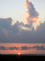
Matalascañas is the name of an Atlantic beach and resort within the Municipality of Almonte, in southwestern Spain. It is known for having an ancient upside down tower on the sand called Torre de la Higuera, one of the seven defensive towers built by Phillip II in the 16th century to protect the coast from incursions by Turkish and North African corsairs and which is protected as a Cultural Interest Asset by the government. This beach is part of the coast of Almonte, which is the longest beach in Spain, being around 30 miles long (53 km) and including several other landmarks like Torre del Loro's Beach, Cuesta Maneli Beach and the virgin beaches of the Doñana National Park, ending at river Guadalquivir. This locale was still called by the tower's name until the 1970s. Matalascañas is surrounded by the Doñana National Park and was segregated from it in 1969 to allow the development of a beach-side tourist village. The mild Mediterranean climate, fine golden sand of the beachfront, mobile dunes and clean water attract tourists throughout the year and the summer nightlife is attractive to young people. Officially established in 1972, its population goes into orbit during the summer, due to its proximity to Seville and being a holiday destination for neighbouring towns and a final residence for retired people. It's been holding the title of Blue flag beach for decades.
Marismas Nacionales–San Blas mangroves is a mangrove ecoregion of the Pacific coast of Mexico. The marismas nacionales stretches from Mazatlán, Sinaloa southwards to San Blas, Nayarit.

Almonte is a town and municipality located in the province of Huelva, in southwestern Spain. According to the 2022 census, it had a population of 25,448 inhabitants, ranking third within its province, just after Huelva, the capital city and Lepe. With its 859.21 km2, it is the 19th largest municipality in Spain, with a population density of 27/km2. Its elevation is 75 m (246 ft) over sea level and it is 50 km far from Huelva. Almonte is recognised worldwide thanks to the village of El Rocío, which had a great influence in the American Wild West culture and hosts one of the most popular pilgrimages in the world. Most of the Doñana National Park, which is Europe's largest natural reserve and a World Heritage Site by UNESCO and the longest beach in Spain, which includes the Matalascañas beach, along with two of the Natural Monuments in Andalusia, are also in Almonte. Moreover, it is one of Spain's top organic fruit exporters and the first blueberry exporter in Europe. Almonte is a founding member of National Park Towns Association Amuparna, the first town to sign the Environmental Treaty and the only municipality in southern Spain to have a presidential residence.

Ayamonte is a town and municipality of Spain belonging to the province of Huelva, Andalusia. It is located near the border with Portugal on the mouth of the Guadiana River. According to the 2015 census, the city had a population of 20,357 inhabitants.

Trebujena is a city and municipality located in the province of Cádiz, part of Andalusia in southern Spain. The area is known for its labor movement and its vineyards.
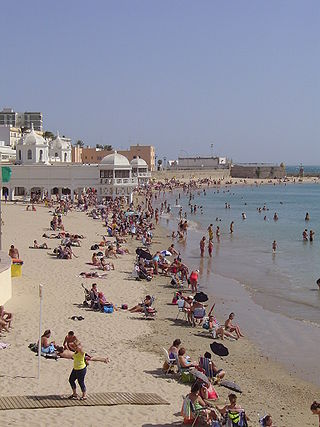
The Costa de la Luz is a section of the Andalusian coast in Spain facing the Atlantic. It extends from Tarifa in the south, along the coasts of the Province of Cádiz and the Province of Huelva, to the mouth of the Guadiana River.

Isla Mayor is a municipality located in the province of Seville, Spain. According to the 2009 census, the municipality has a population of 5873 inhabitants.

Alto Guadalquivir is a Spanish comarca in the province of Córdoba. It covers an area of 1,299 km², and has a population of 44,828 inhabitants. It borders the comarca of Valle de los Pedroches to the North; Campiña Este - Guadajoz to the South; Córdoba and the comarca of Valle del Guadiato to the West; and the province of Jaén to the East.
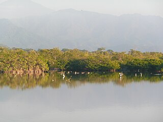
Veta la Palma is an estate (finca) in Andalusia, Spain. It is located on an island in the Guadalquivir river, 10 miles (16 km) inland from the Atlantic Ocean in Seville province of Spain. Prior to the break up of the estate in 2023 it consisted of 11,000 hectares, one of the biggest private properties in the province of Seville. It is recognised for its ecological importance, being included in Doñana Natural Park, the buffer zone of Doñana National Park. The two parks, national and natural, have been classified as a single natural landscape.
Antonio Cano Gea (1917–1987) was a Spanish naturalist, photographer and journalist. He was born in Serón in 1917 and died in Almería in 1987.

Marquess of Marismas del Guadalquivir is a hereditary title in the Peerage of Spain, granted in 1829 by Ferdinand VII to Alejandro María Aguado, an important merchant banker.

The Southwest Iberian Mediterranean sclerophyllous and mixed forests is a Mediterranean forests, woodlands, and scrub ecoregion in southwestern Europe. It occupies the southwestern Iberian Peninsula, encompassing coastal lowlands and mountains in portions of Portugal and Spain.

WWF Spain is the Spanish section of the World Wide Fund for Nature (WWF), which is one of the world's largest organizations dedicated to the conservation of nature, with headquarters in more than 100 countries. Its mission is to halt the environmental degradation of the planet and build a future in which humans live in harmony with nature, through the protection and conservation of biodiversity and the reduction of the ecological footprint.