Guanghan Airport

Last updated
Guanghan Airport
Kwanghan Airfield

广汉机场
Guanghan Jichang
Summary
Airport type Pilot training
Operator Civil Aviation Flight University of China
Location Guanghan, Sichuan, China
Built 1942
Coordinates 30°56′52″N104°19′47″E / 30.94778°N 104.32972°E / 30.94778; 104.32972 Coordinates: 30°56′52″N104°19′47″E / 30.94778°N 104.32972°E / 30.94778; 104.32972
Map
China Sichuan location map.svg
Airplane silhouette.svg
GHN
Location of airport in Sichuan

Guanghan Airport (Chinese :广汉机场) ( IATA : GHN, ICAO : ZUGH) is an airport southeast of Guanghan, Sichuan, China. Formerly a military airfield known as Kwanghan Airfield (A-3) during World War II. It is now used by Civil Aviation Flight University of China for pilot training and has no commercial flights.

Simplified Chinese characters standardized Chinese characters developed in mainland China

Simplified Chinese characters are standardized Chinese characters prescribed in the Table of General Standard Chinese Characters for use in mainland China. Along with traditional Chinese characters, they are one of the two standard character sets of the contemporary Chinese written language. The government of the People's Republic of China in mainland China has promoted them for use in printing since the 1950s and 1960s to encourage literacy. They are officially used in the People's Republic of China and Singapore.

An IATA airport code, also known as an IATA location identifier, IATA station code or simply a location identifier, is a three-letter code designating many airports around the world, defined by the International Air Transport Association (IATA). The characters prominently displayed on baggage tags attached at airport check-in desks are an example of a way these codes are used.

ICAO airport code four-letter code designating many airports around the world

The ICAOairport code or location indicator is a four-letter code designating aerodromes around the world. These codes, as defined by the International Civil Aviation Organization and published in ICAO Document 7910: Location Indicators, are used by air traffic control and airline operations such as flight planning.

Contents

History

During World War II, the airfield was the forward staging base for the 444th Bombardment Group, which carried out B-29 Superfortress raids on the Japanese Home Islands.

World War II 1939–1945 global war

World War II, also known as the Second World War, was a global war that lasted from 1939 to 1945. The vast majority of the world's countries—including all the great powers—eventually formed two opposing military alliances: the Allies and the Axis. A state of total war emerged, directly involving more than 100 million people from over 30 countries. The major participants threw their entire economic, industrial, and scientific capabilities behind the war effort, blurring the distinction between civilian and military resources. World War II was the deadliest conflict in human history, marked by 50 to 85 million fatalities, most of whom were civilians in the Soviet Union and China. It included massacres, the genocide of the Holocaust, strategic bombing, premeditated death from starvation and disease, and the only use of nuclear weapons in war.

Japan Constitutional monarchy in East Asia

Japan is an island country in East Asia. Located in the Pacific Ocean, it lies off the eastern coast of the Asian continent and stretches from the Sea of Okhotsk in the north to the East China Sea and the Philippine Sea in the south.

In 1943, The United States Army Air Force was given rights to use the airfield to stage bombing missions from India to attack Japan. [1] It was one of four B-29 bases established by the Americans in China.

India Country in South Asia

India, also known as the Republic of India, is a country in South Asia. It is the seventh largest country by area and with more than 1.3 billion people, it is the second most populous country as well as the most populous democracy in the world. Bounded by the Indian Ocean on the south, the Arabian Sea on the southwest, and the Bay of Bengal on the southeast, it shares land borders with Pakistan to the west; China, Nepal, and Bhutan to the northeast; and Bangladesh and Myanmar to the east. In the Indian Ocean, India is in the vicinity of Sri Lanka and the Maldives, while its Andaman and Nicobar Islands share a maritime border with Thailand and Indonesia.

The USAAF 444th Bombardment Group (Very Heavy) flew missions from the airfield beginning in mid-June 1944. The group had to transport its supplies of fuel, bombs, and spare parts from its base at Dudhkundi, India over "The Hump" (the name given by Allied pilots to the eastern end of the Himalayan Mountains), since Japanese control of the seas around the Chinese coast made seaborne supply of China impossible. The first mission was carried out on the night of June 14/15, 1944 against the Imperial Iron and Steel Works at Yawata on Kyushu. This plant was considered to be the most important single objective within Japan's steel industry, and had long held top priority for the first strike. It was the first time since the Doolittle raid of 1942 that American aircraft had bombed the Japanese home islands. [1]

Dudhkundi Airfield

Dudhkundi Airfield is an abandoned airfield in India, located 12 miles (19.2 km) SE of Jhargram, in the Jhargram district district in the Indian state of West Bengal.

The Hump

The Hump was the name given by Allied pilots in the Second World War to the eastern end of the Himalayan Mountains over which they flew military transport aircraft from India to China to resupply the Chinese war effort of Chiang Kai-shek and the units of the United States Army Air Forces (AAF) based in China. Creating an airlift presented the AAF a considerable challenge in 1942: it had no units trained or equipped for moving cargo, and no airfields existed in the China Burma India Theater (CBI) for basing the large number of transports that would be needed. Flying over the Himalayas was extremely dangerous and made more difficult by a lack of reliable charts, an absence of radio navigation aids, and a dearth of information about the weather.

Kyushu third largest island of Japan

Kyushu is the third largest island of Japan and most southwesterly of its four main islands. Its alternative ancient names include Kyūkoku(九国, "Nine Countries"), Chinzei(鎮西, "West of the Pacified Area"), and Tsukushi-no-shima(筑紫島, "Island of Tsukushi"). The historical regional name Saikaidō referred to Kyushu and its surrounding islands.

In addition to the bombers, the USAAF 81st Fighter Group used the airfield, flying P-40 Warhawk and P-47 Thunderbolt fighters as part of the Fourteenth Air Force "Flying Tigers". [2] The 81st provided close air support for Chinese Army ground forces fighting the Japanese, as well as flying escort missions for the B-29s over the Japanese-occupied area of China. In January 1945 the B-29 bombers were moved back to India before transferring in April to the newly captured bases in the Mariana Islands. In February, the fighters were moved to a new airfield near Fungwansham. [2] With the departure of the Americans, the much-improved airfield was then returned to Chinese authorities. [1]

Fourteenth Air Force Numbered air force of the United States Air Force responsible for space forces

The Fourteenth Air Force is a numbered air force of the United States Air Force Space Command (AFSPC). It is headquartered at Vandenberg Air Force Base, California.

National Revolutionary Army Nationalist Army of the Republic of China

The National Revolutionary Army (NRA), sometimes shortened to Revolutionary Army (革命軍) before 1928, and as National Army (國軍) after 1928, was the military arm of the Kuomintang from 1925 until 1947 in the Republic of China. It also became the regular army of the ROC during the KMT's period of party rule beginning in 1928. It was renamed the Republic of China Armed Forces after the 1947 Constitution, which instituted civilian control of the military.

Mariana Islands archipelago in western North Pacific Ocean

The Mariana Islands are a crescent-shaped archipelago comprising the summits of fifteen mostly dormant volcanic mountains in the western North Pacific Ocean, between the 12th and 21st parallels north and along the 145th meridian east. They lie south-southeast of Japan, west-southwest of Hawaii, north of New Guinea and east of the Philippines, demarcating the Philippine Sea's eastern limit. They are found in the northern part of the western Oceanic sub-region of Micronesia, and are politically divided into two jurisdictions of the United States: the Commonwealth of the Northern Mariana Islands and, at the southern end of the chain, the territory of Guam. The islands were named after the influential Spanish queen Mariana of Austria.

See also

Related Research Articles

Operation Matterhorn War campaign in WWII

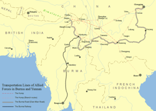
Operation Matterhorn was a military operation of the United States Army Air Forces in World War II for the strategic bombing of Japanese forces by B-29 Superfortresses based in India and China. Targets included Japan itself, and Japanese bases in China and South East Asia. The name comes from the Matterhorn, a mountain traditionally considered particularly difficult to climb.

XX Bomber Command 1941-1948 United States Air Force operational command

The XX Bomber Command is an inactive United States Air Force unit. Its last assignment was with Twentieth Air Force, based on Okinawa. It was inactivated on 16 July 1945.

Twentieth Air Force Numbered air force of the United States Air Force responsible for strategic missile forces

The Twentieth Air Force is a numbered air force of the United States Air Force Global Strike Command (AFGSC). It is headquartered at Francis E. Warren Air Force Base, Wyoming.

58th Air Division Inactive unit of the US Air Force

The 58th Air Division is an inactive United States Air Force unit. Its last assignment was with Air Defense Command, based at Wright Patterson Air Force Base, Ohio. It was inactivated on 1 February 1959.

444th Air Expeditionary Wing

The 444th Air Expeditionary Wing is a provisional unit of the United States Air Force assigned to Air Combat Command to activate or inactivate as needed. It was last activated in 2003.

468th Bombardment Group

The 468th Bombardment Group was a World War II United States Army Air Forces combat organization. It was inactivated on 31 March 1946. The unit served primarily in the Pacific Ocean theater and China Burma India Theater of World War II as part of Twentieth Air Force. The 468th Bomb Group's aircraft engaged in very heavy bombardment B-29 Superfortress operations against Japan. After its reassignment to the Mariana Islands in 1945, its aircraft were identified by a "I" and a triangle painted on the tail.

Lakeland Army Air Field

Lakeland Army Airfield, was a World War II United States Army Air Force located 5.3 miles southwest of Lakeland, Florida. From 1960 to 2017 it was Lakeland Linder Regional Airport. In 2017 it was renamed Lakeland Linder International Airport.

Dinjan Airfield

Dinjan Airfield was a World War II airfield, located in Dinjan, approximately seven miles northeast of Chabua, in the state of Assam, India.

Chakulia Airport airport in India

Chakulia Airport is an airport in India. It is located southwest of Chakulia, a town and a notified area in Purbi Singhbhum district in the state of Jharkhand.

Charra Airfield

Charra Airfield is an abandoned airfield in India, located 5 miles (8.0 km) ExNE of Purulia, in West Bengal.

Piardoba Airfield

Piardoba Airfield is an abandoned airfield in India, located 6.6 miles (10.7 km) S of Bishnupur, West Bengal, Bankura District in the state of West Bengal, India.

Xinjin Airport

Xinjin Airport is an airport in Xinjin County, in the southwestern part of the Chengdu prefecture-level city in Sichuan province of China. The airfield is located approximately 2 km east of the Xinjin County seat, just east of the China National Highway 108. A former military airfield, it is now used by Civil Aviation Flight University of China for pilot training.

Qionglai Air Base

Qionglai Air Base is a People's Liberation Army Air Force (PLAAF) located west of the city of Chengdu, the capital of the province of Sichuan in Southwestern China. More precisely, the facility is located approximately 3 km southwest of Wangsi Town and 2 km northeast of Sangyuan Town, just to the east of 318 National Road. This entire area is located in the northwestern part of the Sichuan Basin, not far from the foothills of the great Qionglai Mountains.

Pengshan Air Base

Pengshan Air Base is a People's Liberation Army Air Force (PLAAF) air base, located approximately 1 km east of Gongyi Town, in Pengshan County, Sichuan province, Southwestern China.

Brooksville Army Airfield

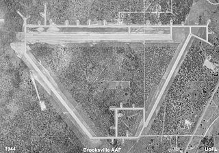
Brooksville Army Airfield, was a United States Army Air Forces airfield constructed during World War II, located 7.2 miles (11.6 km) southwest of Brooksville, Florida.

Chengdu Fenghuangshan Airport

Chengdu Fenghuangshan Airport is military air base in Chengdu, Sichuan province, China. During World War II it was a United States Army Air Forces airfield. It is located approximately 10 miles south of Chengdu.

679th Bombardment Squadron

The 679th Bombardment Squadron is a disbanded unit of the United States Army Air Forces (AAF). It was last assigned to the 444th Bombardment Group at Dudhkundi Airfield, India where it was disbanded on 12 October 1944.

677th Bombardment Squadron

The 677th Bombardment Squadron is an inactive unit of the United States Army Air Forces it was last assigned to the 444th Bombardment Group at Davis-Monthan Field, Arizona.

676th Bombardment Squadron

The 676th Bombardment Squadron is an inactive unit of the United States Army Air Forces it was last assigned to the 444th Bombardment Group at Davis-Monthan Field, Arizona.

References

PD-icon.svg This article incorporates  public domain material from the Air Force Historical Research Agency website http://www.afhra.af.mil/ .

Air Force Historical Research Agency

The Air Force Historical Research Agency is the repository for United States Air Force historical documents. The Agency's collection, begun during World War II in Washington, D.C. and moved in 1949 to Maxwell Air Force Base, the site of Air University, to provide research facilities for professional military education students, the faculty, visiting scholars, and the general public.

  1. 1 2 3 Craven, Wesley Frank; James Lea Cate. "Vol. V: The Pacific: MATTERHORN to Nagasaki, June 1944 to August 1945". The Army Air Forces in World War II. U.S. Office of Air Force History. http://www.ibiblio.org/hyperwar/AAF/V/index.html.
  2. 1 2 Maurer, Maurer (1983). Air Force Combat Units Of World War II. Maxwell AFB, Alabama: Office of Air Force History. ISBN   0-89201-092-4.