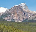
Haddo Peak | |
---|---|
Highest point | |
Elevation | 3,070 m (10,070 ft) [1] [2] |
Prominence | 83 m (272 ft) [1] |
Parent peak | Mount Aberdeen (3152 m) [3] |
Listing | Mountains of Alberta |
Coordinates | 51°23′00″N116°14′12″W / 51.38333°N 116.23667°W [4] |
Geography | |
Country | Canada |
Province | Alberta |
Protected area | Banff National Park |
Parent range | Bow Range Canadian Rockies |
Topo map | NTS 82N8 Lake Louise [4] |
Geology | |
Rock type | Sedimentary |
Climbing | |
First ascent | 1903 by E. Tewes, C. Bohren [1] |
Easiest route | Technical climb via Southwest Ridge |
Haddo Peak is a summit in Alberta, Canada. [4] Haddo Peak is located in the Lake Louise area of Banff National Park.
Haddo Peak honors the name of George Gordon, Lord Haddo. [5] Named in 1916, the name became official in 1952.
Like other mountains in Banff Park, Haddo Peak is composed of sedimentary rock laid down from the Precambrian to Jurassic periods. [6] Formed in shallow seas, this sedimentary rock was pushed east and over the top of younger rock during the Laramide orogeny. [7]
Based on the Köppen climate classification, Haddo Peak is located in a subarctic climate zone with cold, snowy winters, and mild summers. [8] Winter temperatures can drop below −20 °C (−4 °F) with wind chill factors below −30 °C (−22 °F). Weather conditions during summer months are optimum for climbing.
Fairview Mountain is a mountain in Banff National Park situated along the southeastern shoreline of Lake Louise. The mountain was named in 1894 by Walter Wilcox, which reflects the view from the top. An alternate name for the peak is Goat Mountain although it is rarely referred to as such.
Mount Smythe is a mountain in Jasper National Park, Alberta, Canada.
Ptarmigan Peak is a mountain located near Pika Peak in Banff National Park, Alberta, Canada.
Mount Louis is a 2,682-metre (8,799-foot) mountain summit located in southeast Banff National Park in Alberta, Canada. It is part of the Sawback Range which is a subset of the Canadian Rockies.
Mount Saskatchewan is a mountain located in the North Saskatchewan River valley of Banff National Park, in the Canadian Rockies of Alberta, Canada.
Mount Hector is a 3,394-metre (11,135-foot) mountain summit located in the Bow River valley of Banff National Park, in the Canadian Rockies of Alberta, Canada. The mountain was named in 1884 by George M. Dawson after James Hector, a geologist on the Palliser expedition. The mountain is located beside the Icefields Parkway, 17 km (11 mi) north of Lake Louise.
Saint Nicholas Peak is a 2,938-metre (9,639-foot) mountain summit in the Rocky Mountains of Canada. It is located on the Continental Divide, on the Alberta-British Columbia border, in both Banff National Park and Yoho National Park. It lies at the eastern edge of the Wapta Icefield, and is part of the Waputik Mountains which are a sub-range of the Canadian Rockies.
Popes Peak is a mountain on the border of Alberta and British Columbia in Western Canada, on the Continental Divide of the Americas, part of the Bow Range of the Canadian Rockies between Lake Louise Valley and Cataract Brook, bordering Banff and Yoho national parks.
Mount Habel is a 3,073-metre (10,082-foot) mountain summit located in Banff National Park on the Continental Divide along the border of Alberta and British Columbia in the Waputik Mountains, part of the Canadian Rockies. It was named in 1986 after Jean Habel. Jean Habel was a German geographer who explored the Canadian Rockies and in 1897 was the first to set foot on the Wapta Icefield which surrounds Mount Habel.
Mount Aberdeen is a 3,152-metre (10,341-foot) mountain summit located in the Lake Louise area of Banff National Park, in the Canadian Rockies of Alberta, Canada. Its nearest higher peak is Mount Lefroy, 2.9 km (1.8 mi) to the southwest. Haddo Peak is on the same massif with Mount Aberdeen, and the Aberdeen Glacier is between the two peaks.
Mount Birdwood is a 3,097-metre (10,161-foot) summit in the Spray Mountains range of the Canadian Rockies in Alberta, Canada. The mountain is situated on the east boundary of Banff National Park in the upper Spray Lakes River Valley.
Epaulette Mountain is a 3,094-metre (10,151-foot) mountain summit in Alberta, Canada.
Tonsa, or Tonsa Peak, is a 3,053-metre (10,016 ft) mountain summit located on the border of Alberta and British Columbia on the Continental Divide in the Canadian Rockies. The mountain forms part of the backdrop to Moraine Lake in the Valley of the Ten Peaks of Banff National Park. It was named in 1894 by Samuel E.S. Allen for the Stoney Indian word for the number four.
Mount Morrison is a 2,765-metre (9,072-foot) mountain summit located in the upper Spray River Valley of southern Banff National Park, in the Canadian Rockies of Alberta, Canada. Mount Morrison in not visible from any road in Banff Park, however, it can be seen from Alberta Highway 742, also known as the Smith-Dorrien/Spray Trail in Kananaskis Country. Mount Morrison's nearest higher peak is Mount Turner, 1.8 km (1.1 mi) to the north.
The Mitre is a 2,850-metre (9,350-foot) mountain summit located in the Lake Louise area of Banff National Park, in the Canadian Rockies of Alberta, Canada. Its nearest higher peak is Mount Lefroy, 1.0 km (0.62 mi) to the west. Mount Aberdeen is 2.0 km (1.2 mi) to the north-northeast, Lefroy Glacier immediately north, Mitre Glacier southwest, and Paradise Valley to the southeast.
Mount Andromache is a 3,033-metre (9,951-foot) mountain summit located in the Bow River valley of Banff National Park, in the Canadian Rockies of Alberta, Canada. The nearest higher neighbor is Mount Hector, 4.00 km (2.49 mi) to the south. Mount Andromache can be seen from the Icefields Parkway as the road traverses the western base of the peak. Topographic relief is significant as the summit rises 1,180 m (3,870 ft) above the parkway in 1.5 km (0.93 mi). The Molar Glacier is situated on the northeast aspect of the mountain. Precipitation runoff from Mount Andromache drains into tributaries of the Bow River.
Pinnacle Mountain is a 3,070-metre (10,070-foot) mountain summit in Banff National Park in Alberta, Canada. It's part of the Bow Range, which is a sub-range of the Canadian Rockies. The nearest higher peak is Eiffel Peak, 1.0 km (0.62 mi) to the southwest. Mount Temple is situated immediately northeast of Pinnacle Mountain, with Sentinel Pass as the low point between the two.
Mount Outram is a 3,245-metre (10,646-foot) mountain summit located in the Howse River Valley of Banff National Park, in the Canadian Rockies of Alberta, Canada. Its nearest higher peak is Mount Forbes, 4.37 km (2.72 mi) to the southwest. Glacier Lake is situated 4.0 km (2.5 mi) to the north, and the Sir James Glacier lies below the south aspect of the peak. Mount Outram can be seen from the Icefields Parkway southwest of Saskatchewan Crossing, with optimum photography conditions in morning light.
Hilda Peak is a 3,058-metre (10,033-foot) mountain summit located at the northern extreme of Banff National Park in the Canadian Rockies of Alberta, Canada. The nearest higher peak is Mount Athabasca, 2.0 km (1.2 mi) to the southwest. Hilda Peak is situated south of Sunwapta Pass and can be prominently seen from the Icefields Parkway. The Hilda Glacier lies to the south side of the peak, and the Boundary Glacier lies to the west.
Saddle Mountain is a 2,433-metre (7,982 ft) summit in Alberta, Canada.