Hagelstadt

Last updated
Hagelstadt
Langenerling-Kirche-Sankt-Johannes.jpg
Church of Saint John the Baptist in Langenerling
Wappen von Hagelstadt.svg
Coat of arms
Location of Hagelstadt within Regensburg district
Hagelstadt in R.svg
Germany adm location map.svg
Red pog.svg
Hagelstadt
Bavaria location map.svg
Red pog.svg
Hagelstadt
Coordinates: 48°53′45″N12°13′01″E / 48.89583°N 12.21694°E / 48.89583; 12.21694 Coordinates: 48°53′45″N12°13′01″E / 48.89583°N 12.21694°E / 48.89583; 12.21694
Country Germany
State Bavaria
Admin. region Oberpfalz
District Regensburg
Subdivisions5 Ortsteile
Government
   Mayor (202026) Thomas Scheuerer [1]
Area
  Total20.75 km2 (8.01 sq mi)
Elevation
368 m (1,207 ft)
Population
 (2020-12-31) [2]
  Total1,944
  Density94/km2 (240/sq mi)
Time zone UTC+01:00 (CET)
  Summer (DST) UTC+02:00 (CEST)
Postal codes
93095
Dialling codes 09453, 09406 (Langenerling), 09454 (Gailsbach)
Vehicle registration R
Website www.hagelstadt.de

Hagelstadt is a municipality in the district of Regensburg in Bavaria in Germany.

Related Research Articles

Hunding Place in Bavaria, Germany

Hunding is a municipality in the district of Deggendorf in Bavaria in Germany.

Bruckmühl Place in Bavaria, Germany

Bruckmühl is a market town in the district of Rosenheim, in Bavaria, Germany. It is situated on the river Mangfall, 16 km west of Rosenheim.

Ergolding Place in Bavaria, Germany

Ergolding is a municipality in the district of Landshut, in Bavaria, Germany. It is situated on the left bank of the Isar, 5 km northeast of Landshut.

Pleystein Place in Bavaria, Germany

Pleystein is a municipality in the district of Neustadt an der Waldnaab, in Bavaria, Germany. It is situated 18 km east of Weiden in der Oberpfalz, and 11 km west of Rozvadov.

Straßkirchen Place in Bavaria, Germany

Straßkirchen is a municipality in the district of Straubing-Bogen in Bavaria in Germany.

Mönchsroth Place in Bavaria, Germany

Mönchsroth is a municipality in the district of Ansbach in Bavaria in Germany.

Gessertshausen Place in Bavaria, Germany

Gessertshausen is a municipality in the district of Augsburg in Bavaria in Germany. It lies on the Schmutter River.

Bischofswiesen Place in Bavaria, Germany

Bischofswiesen is a municipality in the district of Berchtesgadener Land in Bavaria in Germany.

Wald, Upper Palatinate Place in Bavaria, Germany

Wald is a municipality in the district of Cham in Bavaria in Germany.

Kirchendemenreuth Place in Bavaria, Germany

Kirchendemenreuth is a municipality in the district of Neustadt an der Waldnaab in Bavaria, Germany. It includes the village (Dorf) of Steinreuth.

Leuchtenberg Place in Bavaria, Germany

Leuchtenberg is a municipality in the district of Neustadt an der Waldnaab in Bavaria, Germany, essentially a suburb of nearby Weiden in der Oberpfalz, and a larger historical region in the Holy Roman Empire governed by the Landgraves of Leuchtenberg.

Püchersreuth Place in Bavaria, Germany

Püchersreuth is a municipality in the district of Neustadt an der Waldnaab in Bavaria, Germany.

Beratzhausen Place in Bavaria, Germany

Beratzhausen is a market town and municipality in the district of Regensburg in Bavaria in Germany.

Schierling Place in Bavaria, Germany

Schierling is a municipality in the district of Regensburg in Bavaria in Germany.

Bruck in der Oberpfalz Place in Bavaria, Germany

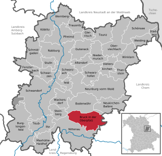
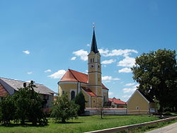
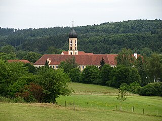
Bruck in der Oberpfalz is a market town in the district of Schwandorf in the Upper Palatinate, Bavaria, Germany.

Altenmarkt an der Alz Place in Bavaria, Germany

Altenmarkt an der Alz is a municipality in the district of Traunstein in Bavaria, Germany.

Güntersleben Place in Bavaria, Germany

Güntersleben is a municipality in the district of Würzburg in Bavaria in Germany.

Rotthalmünster Place in Bavaria, Germany

Rotthalmünster is a municipality in the district of Passau in Bavaria in Germany.

Unterwössen Place in Bavaria, Germany

Unterwössen is a municipality in the district of Traunstein in Bavaria, Germany.

Böbing Place in Bavaria, Germany

Böbing is a municipality in the Weilheim-Schongau district, in Bavaria, Germany.

References

  1. Liste der ersten Bürgermeister/Oberbürgermeister in kreisangehörigen Gemeinden, Bayerisches Landesamt für Statistik, 15 July 2021.
  2. "Tabellenblatt "Daten 2", Statistischer Bericht A1200C 202041 Einwohnerzahlen der Gemeinden, Kreise und Regierungsbezirke". Bayerisches Landesamt für Statistik und Datenverarbeitung (in German). June 2021.