Neutraubling

Last updated
Neutraubling
Neutraubling St.-Michaels-Platz.jpg
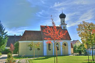
Town square with the Church of Saint Michael
DEU Neutraubling COA.svg
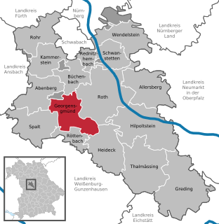
Location of Neutraubling within Regensburg district
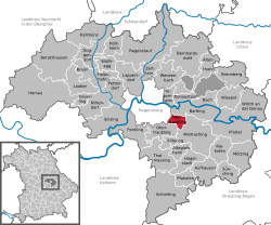
Neutraubling in R.svg
Germany adm location map.svg
Red pog.svg
Neutraubling
Bavaria location map.svg
Red pog.svg
Neutraubling
Coordinates: 48°59′37″N12°11′43″E / 48.99361°N 12.19528°E / 48.99361; 12.19528 Coordinates: 48°59′37″N12°11′43″E / 48.99361°N 12.19528°E / 48.99361; 12.19528
Country Germany
State Bavaria
Admin. region Oberpfalz
District Regensburg
Subdivisions2 Stadtteile
Government
   Mayor (202026) Harald Stadler [1] (FW)
Area
  Total12.00 km2 (4.63 sq mi)
Elevation
330 m (1,080 ft)
Population
 (2020-12-31) [2]
  Total14,018
  Density1,200/km2 (3,000/sq mi)
Time zone UTC+01:00 (CET)
  Summer (DST) UTC+02:00 (CEST)
Postal codes
93073
Dialling codes 09401
Vehicle registration R
Website www.neutraubling.de

Neutraubling is a town in the state of Bavaria in southern Germany, in the district of Regensburg.

Contents

The town has only existed since 1951. After the second world war, displaced ethnic Germans from Sudetenland (Czech Lands) or former eastern territories of Germany (Poland) settled in the ruins of the bombed military airport. Today, it is a more or less important industrial site.

During the Second World War, Neutraubling was used as an airbase and factory for the Messerschmitt aircraft manufacturing company.

Between the end of 1940 and April 23, 1945, the factory was able to house up to 2,750 slave laborers at a time. [3]

Between 20 February 1945 and 26 April 1945, inmates of Flossenbürg concentration camp were held there until forced into a 'death march' to Dachau concentration camp. [4]

Even today, it is possible to find relics of the early history of Neutraubling and its airbase past. For example, what is known as the "Schlangenbau", which is now home to people from various nations all over the world, was the command centre of the airbase. The small pond located next to the Schlangenbau was used as a water reservoir for the airbase fire brigade.

Even the Catholic church there still harbours various signs of the past. It is said that parts of the wall of the church were taken from a destroyed hangar. The main road leading through the city itself has its roots in one of the World War II airstrips.

Despite Neutraubling's earliest roots dating back to the stone age period, it can't compete with Regensburg's rich history. Neutraubling also provides a fully fledged education infrastructure starting with three kindergartens up to a grammar school. Furthermore, Neutraubling is also home to various medium-sized and internationally operating enterprises, e.g. Krones, which has its very roots in this city. Nightlife in Neutraubling is what can be expected from a city of only 13,000 inhabitants.

Church of St. Peter in Lerchenfeld StPeterLerchenfeld.JPG
Church of St. Peter in Lerchenfeld
Town hall Ratskeller und Rathaus auf dem ehemaligen Messerschmitt-Gelande.jpg
Town hall

Number of inhabitants

DayInhabitants
01.04.194753
01.04.19511.296
01.01.19603.755
06.06.19613.994
27.05.19706.097
01.01.19766.614
04.07.198810.036
31.12.200412.950
31.12.200712.509
31.12.201012.808
31.12.201313.255
31.12.201513.431

Mayors since 1951

Local council

The local council has 24 members.

(Elections of the year 2014)

Related Research Articles

Ruhpolding Municipality in Bavaria, Germany

Ruhpolding is the municipality with the biggest area of the Traunstein district in southeastern Bavaria, Germany. It is situated in the south of the Chiemgau region in the Alps and next to the Austrian border.

Kaufbeuren Town in Bavaria, Germany

Kaufbeuren is an independent town in the Regierungsbezirk of Swabia, Bavaria. The town is an enclave within the district of Ostallgäu.

Simbach am Inn Town in Bavaria, Germany

Simbach am Inn is a town on the river Inn in the Rottal-Inn district of Bavaria, Germany. The Austrian city Braunau am Inn lies on the opposite side of the river from Simbach.

Kirchlauter Municipality in Bavaria, Germany

Kirchlauter is a municipality in the Bavarian Administrative Region of Lower Franconia in the district of Haßberge in Germany. It is a part of the Verwaltungsgemeinde of Ebelsbach.

Königsbrunn Municipality in Bavaria, Germany

Königsbrunn is the largest town in the district of Augsburg, in Bavaria, Germany. It is situated on the left bank of the Lech, approx. 10 km south of Augsburg.

Oberasbach Town in Bavaria, Germany

Oberasbach is a municipality in the district of Fürth, in Bavaria, Germany. It is situated 6 km southwest of Fürth, and 10 km west of Nuremberg (centre).

Stadtbergen Town in Bavaria, Germany

Stadtbergen is a town in the district of Augsburg, in Bavaria, Germany. It is situated in the outskirts of Augsburg, 4 kilometres (2.5 mi) west of Augsburg city centre. Stadtbergen was granted town privileges in May 2007.

Gaimersheim Municipality in Bavaria, Germany

Gaimersheim is a municipality in the district of Eichstätt, in Bavaria, Germany. It is situated 7 km northwest of Ingolstadt.

Baiersdorf Town in Bavaria, Germany

Baiersdorf is a town in the district of Erlangen-Höchstadt, in northern Bavaria, Germany.

Heideck Town in Bavaria, Germany

Heideck is a town with full legal town charter in the district of Roth, in Bavaria, Germany. It is situated in the Metropolitan Area of Nuremberg and at the same time in the Franconian Lake District.

Parsberg Town in Bavaria, Germany

Parsberg is a town in the county of Neumarkt in Bavaria, Germany. It is 23 km southeast of Neumarkt in der Oberpfalz, and 33 km northwest of Regensburg, next to the A3 autobahn, the main route from Nuremberg to Regensburg. It was formerly the seat of the Counts of Parsberg, whose coat of arms is now used by the town.

Wörth an der Donau Town in Bavaria, Germany

Wörth an der Donau is a town in the district of Regensburg, in Bavaria, Germany. It is situated on the left bank of the Danube, 22 km east of Regensburg.

Zusmarshausen Municipality in Bavaria, Germany

Zusmarshausen is a municipality in the district of Augsburg, Bavaria, Germany. The 1648 Battle of Zusmarshausen took place here.

Untermeitingen Municipality in Bavaria, Germany

Untermeitingen is a municipality in the district of Augsburg in Bavaria in Germany.

Otting Municipality in Bavaria, Germany

Otting is a municipality in the district of Donau-Ries in Bavaria in Germany.

Neuburg am Inn Municipality in Bavaria, Germany

Neuburg am Inn is a municipality in the district of Passau in Bavaria in Germany.

Brennberg Municipality in Bavaria, Germany

Brennberg is a municipality in the district of Regensburg in Bavaria in Germany.

Obertraubling Municipality in Bavaria, Germany

Obertraubling is a municipality in Bavaria, Upper Palatinate, in the district of Regensburg.

Georgensgmünd Municipality in Bavaria, Germany

Georgensgmünd is a municipality in the district of Roth, in Bavaria, Germany.

Asbach-Bäumenheim Municipality in Bavaria, Germany

Asbach-Bäumenheim is a municipality in the district of Donau-Ries in Bavaria in Germany.

References

  1. Liste der ersten Bürgermeister/Oberbürgermeister in kreisangehörigen Gemeinden, Bayerisches Landesamt für Statistik, 15 July 2021.
  2. "Tabellenblatt "Daten 2", Statistischer Bericht A1200C 202041 Einwohnerzahlen der Gemeinden, Kreise und Regierungsbezirke". Bayerisches Landesamt für Statistik (in German). June 2021.
  3. (German) Helmut Halter: Stadt unterm Hakenkreuz, Universitätsverlag Regensburg 1994, S. 377
  4. "Archived copy" (PDF). Archived from the original (PDF) on 2014-05-15. Retrieved 2012-03-04.CS1 maint: archived copy as title (link) (German) Heike Wolter et al.: Sterben und Überleben im KZ-Außenlager Obertraubling, edition riedenburg 2011