Deuerling

Last updated
Deuerling
St Martin - Deuerling 0345.JPG
Church of Saint Martin
Wappen von Deuerling.svg
Location of Deuerling within Regensburg district
Deuerling in R.svg
Germany adm location map.svg
Red pog.svg
Deuerling
Bavaria location map.svg
Red pog.svg
Deuerling
Coordinates: 49°2′10″N11°54′27″E / 49.03611°N 11.90750°E / 49.03611; 11.90750 Coordinates: 49°2′10″N11°54′27″E / 49.03611°N 11.90750°E / 49.03611; 11.90750
Country Germany
State Bavaria
Admin. region Oberpfalz
District Regensburg
Municipal assoc. Laaber
Subdivisions6 Ortsteile
Government
   Mayor (202026) Diethard Eichhammer [1] (SPD)
Area
  Total7.13 km2 (2.75 sq mi)
Elevation
417 m (1,368 ft)
Population
 (2020-12-31) [2]
  Total2,006
  Density280/km2 (730/sq mi)
Time zone UTC+01:00 (CET)
  Summer (DST) UTC+02:00 (CEST)
Postal codes
93180
Dialling codes 09498
Vehicle registration R
Website www.gemeinde-deuerling.de

Deuerling is a municipality in the district of Regensburg in Bavaria in Germany.

Contents

History


On 24 April 1945, Lieutenant Colonel David H. Arp from Major General Stanley Eric Reinhart's Headquarters Staff searched for a location to set up the Division Command Post from which the assault crossing of the Danube River can be properly supervised and coordinated. He chose Deuerling. [3] The crossing was accomplished in record time.

Weather


The average high temperature in Deuerling is 63 degrees Fahrenheit and the average low temperature is 45 degrees Fahrenheit. [4]

Related Research Articles

<span class="mw-page-title-main">Flossenbürg, Bavaria</span> Municipality in Bavaria, Germany

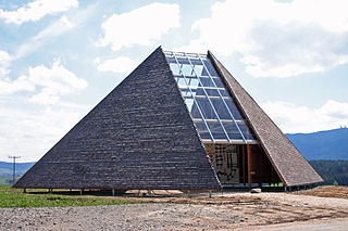
Flossenbürg is a municipality in the district of Neustadt an der Waldnaab in Bavaria in Germany. The state-approved leisure area is located in the Bavarian Forest and borders Bohemia in the east. During World War II, the Flossenbürg concentration camp was located here.

<span class="mw-page-title-main">Schwandorf</span> Town in Bavaria, Germany

Schwandorf is a town on the river Naab in the Upper Palatinate, Bavaria, Germany, which is the seat of the Schwandorf district.

<span class="mw-page-title-main">Münchberg</span> Town in Bavaria, Germany

Münchberg is a small town in Upper Franconia (Bavaria), Germany. It is sometimes referred to as the Textile Town of Bavaria.

<span class="mw-page-title-main">Wildflecken</span> Municipality in Bavaria, Germany

Wildflecken is a municipality in the Bad Kissingen district, at the border of northwestern Bavaria and southern Hesse. In 2005, its population was 3,285; the postal code is 97772. Wildflecken is in the picturesque Rhön mountains.

<span class="mw-page-title-main">Geroldsgrün</span> Municipality in Hof, Bavaria, Germany

Geroldsgrün is a municipality in the Hof district of Bavaria, Germany.

<span class="mw-page-title-main">Hollfeld</span> Town in Bavaria, Germany

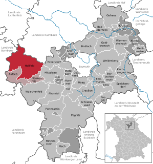
Hollfeld is a town in the district of Bayreuth, in Bavaria, Germany.

<span class="mw-page-title-main">Selbitz</span> Town in Bavaria, Germany

Selbitz is a town in the district of Hof, in Bavaria, Germany. It is situated 12 km west of Hof.

<span class="mw-page-title-main">Waidhaus</span> Municipality in Bavaria, Germany

Waidhaus is a municipality in the district of Neustadt an der Waldnaab in Bavaria, Germany. It lies near the border with the Czech Republic, and near the major border crossing between Bavaria and the Czech Republic, where the Bavarian A6 meets the Czech D5 motorway. The closest towns are on the German side Pleystein and on the Czech side Rozvadov. A gas pipeline and a powerline also cross the border between Bavaria and the Czech Republic there.

<span class="mw-page-title-main">Ahorntal</span> Municipality in Bavaria, Germany

Ahorntal is a municipality in the district of Bayreuth in the state (Bundesland) of Bavaria in Germany.

<span class="mw-page-title-main">Eschlkam</span> Municipality in Bavaria, Germany

Eschlkam is a municipality in the district of Cham in Bavaria in Germany.

<span class="mw-page-title-main">Berg, Upper Franconia</span> Municipality in Bavaria, Germany

Berg is a municipality in the district of Hof in Bavaria, Germany.

<span class="mw-page-title-main">Töpen</span> Municipality in Bavaria, Germany

Töpen is a municipality in Upper Franconia in the district of Hof in Bavaria in Germany.

<span class="mw-page-title-main">Neudrossenfeld</span> Municipality in Bavaria, Germany

Neudrossenfeld is a municipality in the district of Kulmbach in Bavaria in Germany.

<span class="mw-page-title-main">Utting am Ammersee</span> Place in Bavaria, Germany

Utting am Ammersee is a municipality in the district of Landsberg in Bavaria in Germany.

<span class="mw-page-title-main">Winkelhaid</span> Municipality in Bavaria, Germany

Winkelhaid is a municipality in the district of Nürnberger Land in Bavaria in Germany. It is situated 18 km southeast of Nuremberg in the Middle Franconia. Winkelhaid is bounded by the districts of Altdorf bei Nürnberg, Schwarzenbruck and Feucht.

<span class="mw-page-title-main">Bad Füssing</span> Municipality in Bavaria, Germany

Bad Füssing is a municipality in the district of Passau in Bavaria in Germany. Located some 3 km from the river Inn, which creates a border to Austria.

<span class="mw-page-title-main">Türkheim</span> Municipality in Bavaria, Germany

Türkheim is a municipality in the district of Unterallgäu in Bavaria, Germany. The neighboring places of Türkheim are Ettringen, Berg, Rammingen, Irsingen, Wiedergeltingen and Amberg. The administrative collectivity of Türkheim administrate Türkheim and Irsingen. The town is seat of a municipal association with Amberg, Rammingen and Wiedergeltingen.

<span class="mw-page-title-main">Kleinrinderfeld</span> Municipality in Bavaria, Germany

Kleinrinderfeld is a municipality within the district of Würzburg, Bavaria, Germany.

<span class="mw-page-title-main">Hohenfels, Bavaria</span> Municipality in Bavaria, Germany

Hohenfels is a municipality in the district of Neumarkt in the region of Upper Palatinate in Bavaria, Germany. The town is host to the United States Army Garrison Hohenfels, which operates the Joint Multinational Readiness Center for training NATO armed forces.

<span class="mw-page-title-main">Raisting</span> Municipality in Bavaria, Germany

Raisting is a municipality in the Weilheim-Schongau district, in Bavaria, Germany.

References

  1. Liste der ersten Bürgermeister/Oberbürgermeister in kreisangehörigen Gemeinden, Bayerisches Landesamt für Statistik, 15 July 2021.
  2. "Tabellenblatt "Daten 2", Statistischer Bericht A1200C 202041 Einwohnerzahlen der Gemeinden, Kreise und Regierungsbezirke". Bayerisches Landesamt für Statistik (in German). June 2021.
  3. Association, 65th Infantry Division. "65th Infantry Division Association". 65th Infantry Division Association. Retrieved 2022-09-26.
  4. "Deuerling, Germany Weather History | Weather Underground". www.wunderground.com. Retrieved 2022-09-26.