Hemau is a small town in Southern Germany, in the district of Regensburg. The town is situated on the Tangrintel, a ridge which runs between the rivers Altmühl and Schwarze Laber.
Stamsried is a village and municipality in the district of Cham in the Upper Palatinate region of Bavaria, Germany, near the Czech border. It is also located in the Roman Catholic diocese of Regensburg. Stamsried has a population of 2,319 as of June 2004 and an area of 4,343 hectares which includes surrounding countryside outside the built up area of the village itself, the population density is 53.4 persons per square kilometer. Stamsried is located 456 meters above sea level and contains rolling hills as high as 600 meters.

Donaustauf is a market town in Bavaria, 5 km (3 mi) east of Regensburg at the foothills of the Bavarian Forest. The ruins of a medieval castle, presumably erected between 914 and 930, tower above the small town. Situated nearby on a hill rising from the Danube is the imposing Teutonic temple of fame, Walhalla, a costly reproduction of the Parthenon in Athens. The Walhalla was commissioned by Ludwig I, King of Bavaria, and inaugurated on 18 October 1842.

Sünching is a municipality in Germany. It is located in Bavaria, Oberpfalz. It borders in the south to Niederbayern.

Regenstauf is a municipality in the district of Regensburg, in Bavaria, Germany. It is situated on the river Regen, 12 km north of Regensburg.

Burglengenfeld is a town in the district of Schwandorf, in Bavaria, Germany. It is situated on the river Naab, 22 km north of Regensburg.

Rain is a town in the Donau-Ries district, in Bavaria, Germany. It is situated on the river Lech, close to its confluence with the Danube, 11 km east of Donauwörth.

Riedenburg is a town in the district of Kelheim, in Bavaria, Germany. It is situated on the river Altmühl, 16 km (10 mi) northwest of Kelheim and 29 km (18 mi) northeast of Ingolstadt. Prunn Castle is located in Riedenburg.

Wörth an der Donau is a town in the district of Regensburg, in Bavaria, Germany. It is situated on the left bank of the Danube, 22 km east of Regensburg.
Rügland is a municipality in the district of Ansbach in Bavaria in Germany.

Mespelbrunn is a community in the Aschaffenburg district in the Regierungsbezirk of Lower Franconia (Unterfranken) in Bavaria, Germany and a member of the Verwaltungsgemeinschaft of Mespelbrunn, whose seat is in Heimbuchenthal.

Nordendorf is a municipality in the district of Augsburg in Bavaria in Germany.

Adelsdorf is a municipality in the district of Erlangen-Höchstadt, in Bavaria, Germany.

Neufahrn i. NB or Neufahrn in Niederbayern is a municipality in the district of Landshut in Bavaria in Germany. Its Bavarian name is Neifing.

Lupburg is a municipality in the district of Neumarkt in Bavaria in Germany.

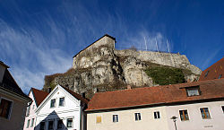
Kallmünz is a municipality in the district of Regensburg in Bavaria, Germany. Located on Naab River about 25 km north of Regensburg, Kallmünz has preserved a beautiful medieval center. The main attractions are the ruins of the Kallmünz Castle above the town on a cliff and the old stone bridge over the Naab River. The Russian painter Wassily Kandinsky and the German expressionist painter Gabriele Münter met in Kallmünz during the summer of 1903. Since then, Kallmünz has been the constant home of a small art colony.

Nittendorf is a municipality in the district of Regensburg in Bavaria in Germany.

Sinzing is a municipality in the district of Regensburg in Bavaria in Germany.
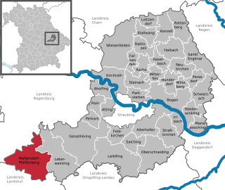
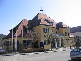
Mallersdorf-Pfaffenberg is a municipality in the district of Straubing-Bogen in Bavaria, Germany and has around 7,000 inhabitants.

Holzheim am Forst is a municipality in the district of Regensburg in Bavaria in Germany. The municipality, together with the community Duggendorf and the market town Kallmünz belong to the administrative community Kallmünz.