There are the Gemarkungen of Altenthann, Forstmühler Forst, Göppenbach, Lichtenwald and Pfaffenfang.
Climate
Precipitation diagram
Altenthann has a humid climate and lies within the cool-temperate climatic zone. The municipality is located in the transition area between the moist Atlantic and the dry continental climate regions. According to the climate classification by Köppen-Geiger, Franconia, including Altenthann, is part of the 'warm temperate rain climate'(Cfb climate). As a result the average air temperatures in the warmest months are below 22°C (72°F) and in the coldest months are above −3°C (27°F).
The annual precipitation is 742 millimetres, which is in the middle third of the weather station records by the German Met Office; 50% of the weather stations having lower values. The driest month is October; the wettest is June, when there is 1.9 times the rain of the driest month. The annual precipitation variations lie in the upper third. In over 77% of places the variation is less.
History
Before the municipality was created
Altenthann belonged to the economic district of Straubing (Rentamt[bar; de; es] Straubing) and the juridical district of Stadtamhof (Landgericht Stadtamhof) in the Electorate of Bavaria. From 1664 until secularisation, Frauenzell Abbey had an open Hofmark here. In the wake of administrative reforms in the Kingdom of Bavaria the present municipality emerged as a result of the 1818 Municipality Edict.
Incorporations
In 1945 or 1946 the hitherto independent municipality of Pfaffenfang (Landkreis Roding) and parts of the municipality of Göppenbach were incorporated into Altenthann.[4] On 1 January 1978 Lichtenwald was added.[5]
Population growth
1961: 1,235
1970: 1,283
1987: 1,315
1991: 1,441
1995: 1,471
2000: 1,538
2005: 1,580
2010: 1,549
2015: 1,513
20th and 21st centuries
In the past decades Altenthann has developed from an agricultural village into a residential area as a result of the designation of building land and investment in its infrastructure. Important aims of the municipality are currently investment in regenerative, environmentally friendly energy, energy-saving technology, further development of the infrastructure and broadband availability.
The council consists of twelve members. Since the election in 2014 there are 6 CSU members and 6 members of the Freie Wähler.
Mayor
The mayor (Bürgermeister) since May 2014 is Harald Herrmann (FW).
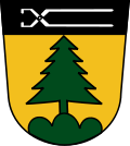
Coat of arms
Blazon: Or, a fir tree on three hills vert, on a chief sable pincers argent (Unter schwarzem Schildhaupt, darin eine silberne Zange, in Gold auf grünem Dreiberg eine grüne Tanne.)
Aschenbrennermarter Hunting Lodge dating to 1900 in the Forstmühlen Forest
Parish Church of St. Nicholas: in 1832 the 1712 church of St. Nicholas almost entirely burned to the ground. It was demolished in 1904 and replaced by a new church designed by Heinrich Hauberrisser. Only the side altars and the chancel still date to 1830. The high altar by Josef Wittmann dates to 1910.
Fürstlicher Thiergarten
Museum
Local history museum of the county of Regensburg in the multi-purpose hall in Altenthann: collection of handicraft products and farming implements. They give an insight into the development of the Bavarian foothills and old customs.
Leisure and nature
There are numerous cycleways and footpaths around the village that lead into the extensive woods. There is a lido about 14 kilometres away in Falkenstein which is open in summer. The nearest indoor swimming pool is in the town of Wörth an der Donau. In winter, there are facilities for skiers, tobogganists and ice stock players.
Sports and clubs
There are over 20 clubs in the municipality, including a sports club. Altenthann has several sports facilities including a tennis court and a multi-purpose hall.
The Altenthan Volunteer Fire Brigade (Freiwillige Feuerwehr Altenthann) and the fire crews of the various villages in the municipality provide a fire services and general assistance.
Economy and infrastructure
Altenthann is a residential community and is equipped with basic local amenities and but does not itself have any central local significance. It is located in the catchment area of the city of Regensburg.
Economy
In the municipality there are several service, handicraft and commercial enterprises, the main building trades are particularly strongly represented and agriculture is also important.
"Altenthann Nord I" is a designated building area.
Arbeitsgemeinschaft Vorderer Bayerischer Wald
On 8 January 2007, the working group Vorderer Bayerischer Wald ("AG Vorwald" for short),[7] was founded. Its aim is to promote and strengthen the region in terms of tourism, economy and culture. The members of this working group are the municipalities of Altenthann, Bernhardswald, Brennberg, Falkenstein, Michelsneukirchen, Rettenbach, Wald, Wiesenfelden, Zell and the town of Wörth an der Donau. All local tourist associations of these municipalities are members too.
Tourism
The municipality has numerous holiday apartments and private quarters. Tourism is focused on "farm holidays".
There is an Altenthann - Bernhardswald - Kürn tourist office.
The main local newspapers and magazines delivered to the municipality include the Donau-Post, a local edition of the Straubinger Tagblatt and the Bayerwaldecho, a local edition of the Mittelbayerische Zeitung and the Regensburger Wochenblatt, a publication of the Wochenblatt Verlagsgruppe.
↑ Wilhelm Volkert (1983). Handbuch der bayerischen Ämter, Gemeinden und Gerichte 1799–1980. Munich: C. H. Beck. p.555. ISBN3-406-09669-7. record.
↑ Statistisches Bundesamt, ed. (1983), Historisches Gemeindeverzeichnis für die Bundesrepublik Deutschland. Namens-, Grenz- und Schlüsselnummernänderungen bei Gemeinden, Kreisen und Regierungsbezirken vom 27. 5. 1970 bis 31. 12. 1982 (in German), Stuttgart/Mainz: W. Kohlhammer, p.657, ISBN3-17-003263-1
This page is based on this Wikipedia article Text is available under the CC BY-SA 4.0 license; additional terms may apply. Images, videos and audio are available under their respective licenses.