Hailwood's Height, preceded by Hailwood's Rise, is situated between the 31st and 32nd Milestone road-side markers on the Snaefell Mountain Course used for the Isle of Man TT Races on the A18 Snaefell Mountain Road in the parishes of Lezayre and Lonan in the Isle of Man.
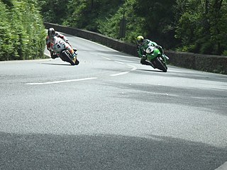
The Isle of Man TT or Tourist Trophy races are an annual motorcycle sport event run on the Isle of Man in May/June of most years since its inaugural race in 1907, and is often called one of the most dangerous racing events in the world.
Lezayre, formally Kirk Christ Lezayre, is one of the seventeen parishes of the Isle of Man.
Lonan is one of the seventeen parishes of the Isle of Man.
The uphill section of the Mountain Course from the Bungalow to the highest point of the course at Ordnance Survey spot height422 metres (1,385ft) above sea level near Brandywell was named Hailwood's Rise in memory of Mike Hailwood, the former world motorcycle champion who died in 1981. The highest point of the course adjacent to the Brandywell/B10 road junction is named Hailwood's Height.[1]
A spot height is an exact point on a map with an elevation recorded beside it that represents its height above a given datum. In the UK this is the Ordnance Datum. Unlike a bench-mark, which is marked by a disc or plate, there is no official indication of a spot height on the ground although, in open country, spot heights may sometimes be marked by cairns. In geoscience, it can be used for showing elevations on a map, alongside contours, bench marks, etc.
Brandywell, Isle of Man or is an area of Mountain Lands of heath moorland and coniferous woodland plantations situated in the Northern Upland Massif in the parish of Kirk Michael in the Isle of Man. The area was previously used by local shepherds due to a local stream and a nearby former venerated water well which was known for its distinctive quality and “brandy” colour of the water.
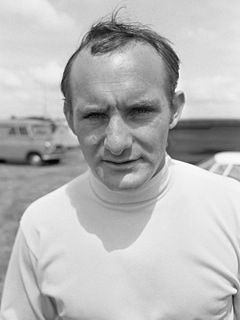
Stanley Michael Bailey Hailwood,, was a British Grand Prix motorcycle road racer. He is regarded by many as one of the greatest racers of all time.
The Four Inch Course was a road-racing circuit first used for the 1908 Tourist Trophy Race for cars, held on public roads closed for racing by an Act of Tynwald. The name of the course derives from the regulations for the 1908 Tourist Trophy adopted by the Royal Automobile Club, which limited the competitors' engines to a cylinder-diameter of four inches. The Four-Inch Course was adopted by the Auto-Cycle Club for the 1911 Isle of Man TT Races. The Four-Inch Course was subsequently known as the Snaefell Mountain Course or Mountain Course when used for motor-cycle racing.
The International Tourist Trophy is an award given by the Royal Automobile Club (RAC) and awarded semi-annually to the winners of a selected motor racing event each year in the United Kingdom. It was first awarded in 1905 and continues to be awarded to this day, making it the longest lasting continually-awarded trophy in motorsports. Tourist Trophy events have been part of major national and international racing series, including the World Sportscar Championship, World Touring Car Championship, European Touring Car Championship, FIA GT Championship, and British Touring Car Championship. It has been awarded to races within a championship, and as a standalone event on various occasions. From 2013, It was announced that the Tourist Trophy would be awarded as part of the 6 Hours of Silverstone in the FIA World Endurance Championship, the first time it has been awarded as part of a sportscar world championship since 1964.
The Manx Grand Prix motorcycle races are held on the Isle of Man TT Course every year for a two-week period, usually spanning the end of August and early September.
Sources
↑ Isle of Man TT Festival Fortnight 1-12 June 1981 - Official Souvenir Programme page 17 Isle of Man Tourist Board The Auto-Cycle Union (1981) J.M. Noble Ltd, Isle of Man
A geographic coordinate system is a coordinate system that enables every location on Earth to be specified by a set of numbers, letters or symbols. The coordinates are often chosen such that one of the numbers represents a vertical position and two or three of the numbers represent a horizontal position; alternatively, a geographic position may be expressed in a combined three-dimensional Cartesian vector. A common choice of coordinates is latitude, longitude and elevation. To specify a location on a plane requires a map projection.
The A18 Snaefell Mountain Road or Mountain Road is a primary main A-road of 13.35 miles (21.48 km) in length which connects the towns of Douglas and Ramsey in the Isle of Man.
The Isle of Man TT Mountain Course or TT Course is a motor-cycle road- racing circuit located in the Isle of Man. The motor-cycle TT Course is used principally for the Isle of Man TT Races and also the separate event of the Isle of Man Festival of Motorcycling for the Manx Grand Prix and Classic TT Races held in September of each year. The start-line for the Isle of Man TT Mountain Course is located on Glencrutchery Road in the town of Douglas, Isle of Man.
Handley's Corner is situated just before the 12th Milestone road-side marker, measured from the startline at the TT Grandstand, on the Snaefell Mountain Course used for the Isle of Man TT races on the primary A3 road, in the parish of Michael, in the Isle of Man.
Ramsey Hairpin is a point on the Snaefell Mountain Course used for the Isle of Man TT races on the Snaefell Mountain Road, designated as A18, in the parish of Maughold in the Isle of Man.
Ballig is a small hamlet of a few houses situated between the 8th and 9th Milestone road-side markers on the Snaefell Mountain Course between Ballacraine and Glen Helen. It is the site of a former notorious hump-back bridge used for the Isle of Man TT Races on the primary A3 Castletown to Ramsey and the road junction with the A20 Poortown Road in the parish of German in the Isle of Man.
Brandish Corner is situated between the 35th and 36th Milestone road-side markers on the Snaefell Mountain Course on the primary A18 Mountain Road in the parish of Onchan in the Isle of Man. The road was re-engineered in recent years.
The Bungalow, Isle of Man, one of a handful of better-known vantage points spread around the Snaefell Mountain Course, is situated adjacent to the 31st Milestone roadside marker on the road junction of the primary A18 Mountain Road, the A14 Sulby Glen Road and the road-tramway crossing for the Snaefell Mountain Railway in the parish of Lezayre in the Isle of Man.
Sarah's Cottage is one of the named corners of the Snaefell Mountain Course used for the Isle of Man TT races. It is situated between the 9th and 10th road side mile-markers at Ballavaish on the primary A3 Castletown to Ramsey Road in the Isle of Man parish of German. A right-turning bend on the course, turning from a north-west direction to the north-east, it precedes Creg Willey's and Lambfell,.
Ballacraine, also known as Ballacraine Corner, is one of the named corners of the Snaefell Mountain Course, the motorcycle racing course of the Isle of Man TT and Manx Grand Prix.
Ballagarraghyn is situated between the 7th and 8th Milestone road-side markers on the Snaefell Mountain Course used for the Isle of Man TT races on the primary A1 Douglas to Peel road in the parish of German in the Isle of Man.
Ballaugh Bridge,, is a hump-backed road bridge over a stream situated between the 17th and 18th Milestone road-side markers on the Snaefell Mountain Course in Ballaugh village, on the primary A3 Castletown-to-Ramsey road and adjacent side junctions with the A10 Ballaugh-to-Ramsey coast road and the tertiary C37 Ballaugh Glen Road in the parish of Ballaugh in the Isle of Man.
Ballacrye Corner is situated between the 17th and 18th Milestone road-side markers on the Snaefell Mountain Course on the primary A3 Castletown to Ramsey road, in the parish of Ballaugh in the Isle of Man.
Cronk-ny-Mona is situated between the 36 and 37 mile markers used for the Snaefell Mountain Course, being on the primary A18 Mountain Road at the road junction with the A21 Johnny Watterson('s) Lane and the tertiary C10 Scholag Road in the Isle of Man parish of Onchan.
The Mountain Mile is a 1.3 mile section of a purpose-built graded road situated between the 27th and 29th Milestone roadside markers on the Snaefell Mountain Course used for the Isle of Man TT and Manx Grand Prix races on the A18 Mountain Road in the parish of Lezayre in the Isle of Man.
Glen Duff is a point on the Mountain Course used for the Isle of Man TT and Manx Grand Prix races situated between the 21st and 22nd Milestone road-side markers on the 37+ mile circuitous road-race course, measured from the startline at the TT Grandstand,
Ballacobb is situated between the 16th and 17th Milestone road-side markers on the Snaefell Mountain Course, on the primary A3 Castletown to Ramsey road at the side-junction with the tertiary U16 Slieu Curn Road, in the parish of Ballaugh in the Isle of Man.
Whitegates, a left-curve, is situated adjacent the 24th Milestone road-side marker on the Snaefell Mountain Course used for the Isle of Man TT Races and the 15th Milestone on the primary A18 Snaefell Mountain Road in the town of Ramsey, Isle of Man in the Isle of Man.
Douglas Road Corner or Kirk Michael Corner is situated adjacent the 14th Milestone road-side marker on the Snaefell Mountain Course on the primary A3 Castletown to Ramsey Road and the road junction with the A4 Peel to Kirk Michael Coast Road in the parish of Michael in the Isle of Man.
This page is based on this Wikipedia article Text is available under the CC BY-SA 4.0 license; additional terms may apply. Images, videos and audio are available under their respective licenses.