Rich County is a county in the U.S. state of Utah. As of the 2020 United States Census, the population was 2,510, making it the third-least populous county in Utah. Its county seat is Randolph, and the largest town is Garden City. The county was created in 1864. It was named for an early LDS apostle, Charles C. Rich.
Keetley is a ghost town located in northeastern Wasatch County, Utah, United States.

The Price River is a 137-mile-long (220 km) southeastward flowing river in Carbon, Utah and Emery counties in eastern Utah. It is a tributary to the Green River, itself a tributary to the Colorado River.

Royal is a ghost town that existed in the early 1900s as a small coal mining town in Carbon County, Utah, United States. Originally called Bear Canyon, the town was renamed Cameron, Rolapp, and finally Royal when the Royal Coal Company purchased it, changing names each time a new owner took over. All that remains of Royal today are some stone walls, a couple of the mines, and a miner's dwelling. These remnants can be seen in Price Canyon.

Frisco is a ghost town in Beaver County, Utah, United States. It was an active mining camp from 1879 to 1929. At its peak in 1885, Frisco was a thriving town of 6,000 people.

Tucker is a ghost town located near the east end of the Spanish Fork River in Utah County, Utah, United States 7 miles (11 km) below Soldier Summit on U.S. Route 6. It was once an important loading point and construction camp on the Denver and Rio Grande Western Railroad (D&RGW). After the town was abandoned, the state of Utah used the town site for a rest area. In 2009, the site was buried as part of a project to re-align a portion of US-6's western approach to Soldier Summit. To honor the town, the state of Utah built a replacement rest area about 2 miles (3.2 km) downstream from Tucker, called the Tie Fork Rest Area.

Colton is a ghost town located near the southeastern edge of Utah County, Utah, United States, approximately 6 miles (9.7 km) south of Soldier Summit. Formerly a busy railroad junction on the Denver and Rio Grande Western Railroad, Colton is a landmark on U.S. Route 6 between the cities of Spanish Fork and Price.
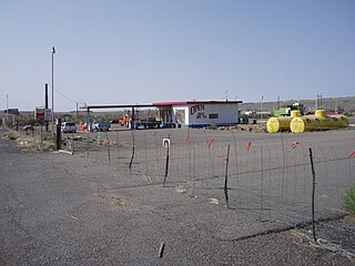
Woodside is a ghost town located on the west bank of the shallow Price River in the nearly uninhabited eastern part of Emery County, Utah, United States. Its fenced-in filling station is one of the only signs of human activity along the lonely stretch of U.S. Route 6/191 between Wellington and Green River.

Scofield Reservoir is a 2,815-acre (11.39 km2) reservoir impounded by Scofield Dam, in Carbon County, Utah. Located on the Price River, a tributary of the Green River, Scofield Reservoir is adjacent to the northernmost boundary of the Manti–La Sal National Forest. The reservoir sits at an elevation of 7,618 feet (2,322 m), on the northern edge of the Wasatch Plateau. Utah State Route 96 runs along the western shoreline.

State Route 96 (SR-96) is a state highway in the U.S. state of Utah, connecting SR-264 and the town of Scofield to US-6 in a span of 22.76 miles (36.63 km). The route is known as the Eccles Canyon Scenic Byway, part of The Energy Loop, a National Scenic Byway.
Hailstone was a town in northern Wasatch County, Utah, United States.
Winter Quarters is a ghost town in Carbon County, Utah, United States. Coal was discovered in the area in 1875, and later that year, the Pleasant Valley Coal Company began coal mining operations. A group of coal miners were delayed during an early winter storm in 1877, which led to the town's name of Winter Quarters. On May 1, 1900, an explosion in the Winter Quarters Number Four mine killed 200 miners. Despite the mine explosion, the coal mining operations remained active until 1922, when the opening of a new mine in Castle Gate caused many people to relocate there. By 1930, Winter Quarters was abandoned.
Aspen Cove at Scofield is a 632-acre (256 ha) recreational property cabin development on the northwest end of Scofield reservoir in the state of Utah. Aspen Cove is primarily a recreation destination. The 2010 population is 7 year round residents and there are over 50 cabins used as second homes. Aspen Cove is less than a 10 mile drive to the town of Scofield, 35 miles to Price, 50 miles to Spanish Fork, and 100 miles to Salt Lake City, Utah.
The Scofield Mine disaster was a mining explosion that occurred at the Winter Quarters coal mine on May 1, 1900. The mine was located at 39°42′57″N111°11′17″W near the town of Scofield, Utah. In terms of life lost, it was the worst mining accident at that point in American history. The explosion is also a key element in the plot of the Carla Kelly novel My Loving Vigil Keeping.
Desert Lake is a ghost town in Castle Valley in northern Emery County, Utah, United States. It was inhabited from 1885 to about 1910.
Juab is a ghost town in Juab County, Utah, United States. It lies at an elevation of 5,082 feet (1,549 m), and is 5.1 miles (8.2 km) west-southwest of Levan.
Chicken Creek is a ghost town in southeastern Juab County, Utah, United States.
Consumers is a ghost town in Carbon County, Utah, United States. It is located in the Gordon Valley near several other former coal mining communities that also are now ghost towns. It is less than a mile from the ghost town of National, and also quite near to Clear Creek.
Bacchus is a ghost town in Salt Lake County, Utah, United States.
Jordanelle was a community in northern Wasatch County, Utah, United States.