Related Research Articles

Helper is a city in Carbon County, Utah, United States, approximately 110 miles (180 km) southeast of Salt Lake City and 7 miles (11 km) northwest of the city of Price. The population was 2,201 at the 2010 census.

Scofield is a town in Carbon County, Utah, United States. The population was 23 at the 2010 census. Scofield's name is frequently applied to the 1900 mine disaster in the Pleasant Valley Coal Company's Winter Quarters mine. The community was named for General Charles W. Scofield, a timber contractor and local mine official. It is the smallest incorporated area in Utah by population.

Hiawatha is an unincorporated community and near-ghost town, formerly a coal mining town in southwestern Carbon County, Utah, United States. While the town's former corporate limits were almost entirely within Carbon County, the western part was within the Manti-La Sal National Forest and a very small part extended west into Emery County.

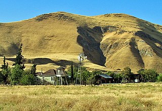
Royal is a ghost town that existed in the early 1900s as a small coal mining town in Carbon County, Utah, United States. Originally called Bear Canyon, the town was renamed Cameron, Rolapp, and finally Royal when the Royal Coal Company purchased it, changing names each time a new owner took over. All that remains of Royal today are some stone walls, a couple of the mines, and a miner's dwelling. These remnants can be seen in Price Canyon.

Castle Gate is a ghost town in the western United States, located in Carbon County in eastern Utah. A mining town approximately ninety miles (140 km) southeast of Salt Lake City, its name was derived from a rock formation near the mouth of Price Canyon. This formation features two sheer sandstone walls on either side of the Price River, which appear to open like a giant gate as travelers approach this narrow section of the canyon.
The Black Diamond Mines Regional Preserve is a 6,000-acre (2,400 ha) park located north of Mount Diablo in Contra Costa County, California under the administration of the East Bay Regional Park District (EBRPD). The district acquired the property in 1973. The preserve contains relics of 3 mining towns, former coal and sand mines, and offers guided tours of a former sand mine. The 60 miles (97 km) of trails in the Preserve cross rolling foothill terrain covered with grassland, California oak woodland, California mixed evergreen forest, and chaparral.
The Wilberg Mine is a coal mine in Emery County, Utah, approximately 12 miles (19 km) northwest of Orangeville, just north of State Route 29, at the northern terminus of State Route 57. The mine is operated by the Energy West Mining Company and owned by PacifiCorp Energy(a division of power utility company PacifiCorp).
Mohrland is a ghost town located in Emery County, Utah, United States. Lying in Cedar Creek Canyon near the Carbon County line, Mohrland was Emery County's largest coal mining town, with a history more typical of Carbon County's coal camps than of most Emery County communities.
Connellsville is a ghost town located high in the mountains of Coal Canyon, near the head of Huntington Canyon in the northwestern corner of Emery County, Utah, United States. A coal mining and coke manufacturing center, Connellsville was the first settlement in what is now Emery County, inhabited from 1874 to 1878. The town now lies beneath the waters of Electric Lake.

Sego is a ghost town in Grand County, Utah, United States. It lies in the narrow, winding Sego Canyon, in the Book Cliffs some 5 miles (8.0 km) north of Thompson Springs. Formerly an important eastern Utah coal mining town, Sego was inhabited about 1910–1955. The town is accessed via the grade of the Ballard & Thompson Railroad, a spur from the Denver and Rio Grande Western built by the founders of the town to transport the coal.

Clear Creek is a census-designated place on the western edge of Carbon County, Utah, United States. It is located at the south end of State Route 96 and the Pleasant Valley Branch of the Union Pacific Railroad.
Grass Creek is a ghost town in Summit County, Utah, United States. Lying some 8 miles (13 km) northeast of Coalville, it was once an important coal mining town. Grass Creek was inhabited circa 1860–1940.

Standardville is a ghost town in Carbon County, Utah, United States. Standardville was established after coal was discovered in the area in 1912. The layout of the town was so well-planned, it became the "standard" for all mining towns to follow, which resulted in the town name of Standardville. In 1922, a group of striking miners killed a mine guard and wounded two miners before escaping. In 1930, 20 miners were killed in a mine explosion caused by carbon monoxide gas. In 1950, the mine shut down and people began to relocate elsewhere. A couple families remained until the 1970s, after which Standardville was abandoned.
Coal City is a ghost town in Carbon County, Utah, United States. Established in 1885, Coal City was initially a farming community until coal was discovered in the area. Small-scale mining began to take place, and because the mining operations were a mile or two away from the mines at National and Consumers, it was assumed that the citizens of the town would lack workplace stress. Coal production began to decline in 1935, and the town was essentially abandoned with just two residences occupied by the late 1960s.
Winter Quarters is a ghost town in Carbon County, Utah, United States. Coal was discovered in the area in 1875, and later that year, the Pleasant Valley Coal Company began coal mining operations. A group of coal miners were delayed during an early winter storm in 1877, which led to the town's name of Winter Quarters. On May 1, 1900, an explosion in the Winter Quarters Number Four mine killed 200 miners. Despite the mine explosion, the coal mining operations remained active until 1922, when the opening of a new mine in Castle Gate caused many people to relocate there. By 1930, Winter Quarters was abandoned.
National is a ghost town in Carbon County, Utah, United States. It is located along upper Gordon Creek.
Peerless is a ghost town in Carbon County, Utah, United States. It is located just 3 miles (4.8 km) west of Helper.
Dragon is a ghost town in Uintah County, at the extreme eastern edge of Utah, United States. Founded in about 1888 as a Gilsonite mining camp, Dragon boomed in the first decade of the 20th century as the end-of-line town for the Uintah Railway. Although it declined when the terminus moved farther north in 1911, Dragon survived as the largest of the Gilsonite towns. It was abandoned after its mining operations stopped in 1938 and the Uintah Railway went out of business in 1939.
Golden is a ghost town in Box Elder County, Utah, United States. It is located 6 miles (9.7 km) west of Park Valley, near the southern base of the Raft River Mountains.
The Scofield Mine disaster was a mining explosion that occurred at the Winter Quarters coal mine on May 1, 1900. The mine was located at 39°42′57″N111°11′17″W near the town of Scofield, Utah. In terms of life lost, it was the worst mining accident at that point in American history. The explosion is also a key element in the plot of the Carla Kelly novel My Loving Vigil Keeping.
References
Municipalities and communities of Carbon County, Utah, United States | ||
|---|---|---|
| Cities |  | |
| Town | ||
| CDPs | ||
| Indian reservation | ||
| Ghost towns | ||
| Footnotes | ‡This populated place also has portions in an adjacent county or counties | |
39°42′02″N111°03′46″W / 39.70056°N 111.06278°W
| | This United States ghost town-related article is a stub. You can help Wikipedia by expanding it. |