Standardville, Utah

Last updated
Standardville
Standardville coal storage.jpg
The coal storage unit in Standardville
USA Utah location map.svg
Red pog.svg
Standardville
Location of Standardville in Utah
Usa edcp location map.svg
Red pog.svg
Standardville
Standardville (the United States)
Coordinates: 39°42′00″N110°56′01″W / 39.70000°N 110.93361°W / 39.70000; -110.93361 Coordinates: 39°42′00″N110°56′01″W / 39.70000°N 110.93361°W / 39.70000; -110.93361
Country United States
State Utah
County Carbon
Founded1912
Abandoned1970s
Named for The "standard" for all mining towns to follow
Elevation
[1]
6,739 ft (2,054 m)
GNIS feature ID1437692 [1]

Standardville is a ghost town in Carbon County, Utah, United States. Standardville was established after coal was discovered in the area in 1912. The layout of the town was so well-planned, it became the "standard" for all mining towns to follow, which resulted in the town name of Standardville. In 1922, a group of striking miners killed a mine guard and wounded two miners before escaping. In 1930, 20 miners were killed in a mine explosion caused by carbon monoxide gas. In 1950, the mine shut down and people began to relocate elsewhere. A couple families remained until the 1970s, after which Standardville was abandoned.

Contents

History

The town was established after coal was discovered in Spring Canyon in 1912. The town layout was planned with well maintained lawns, bushes, and poplar trees. This became the "standard" for coal mining towns in Spring Canyon, and the town was named Standardville. [2] As Standardville's population increased, a company store, several apartments, a butcher shop, a barber shop, a hospital, a recreation hall, tennis courts, and an elementary school were constructed. At its peak, the population was about 550. [3] Although it was considered the standard for mining towns, Standardville still had problems with crime. On June 14, 1922, several miners went on strike and attacked a train carrying several new miners from both sides. The striking miners then fled and were pursued by mine guards. The shooting that occurred killed a mine guard and wounded two others. [4]

On February 6, 1930, an explosion caused by firedamp gas occurred in the Standard mine. Of the 29 miners that were working in the mine, 20 were immediately killed by the explosion. Rescue workers attempted to rescue the nine survivors, and while they were searching, a cave-in killed three of them. The nine survivors were able to escape. [5] The explosion had a large impact on the mine and community; however, the town continued to grow.

When World War II ended, the demand for coal decreased, and the mine was unable to meet its payroll as a result. In an attempt to save the mine, miners worked only for food. This attempt was unsuccessful, and the mine went bankrupt and was foreclosed on. Another coal mining company bought it, and shipments continued a couple months later. By 1948, the mine was being operated by the Spring Canyon Coal Company; however, in 1950, the mine was closed. As miners moved away, shops, the hospital, and the school were closed. Despite this, two families continued to live in the town until the 1970s. [3]

Remnants

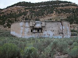
The coal tipple has deteriorated, leaving behind the coal storage unit. Numerous foundations can be found. At the top of the hill lies the bath house, where miners bathed and changed clothes. Remains of the Standard Mine can be found beyond the bath house. Railroad tracks that were once the property of the Denver and Rio Grande Western Railroad end in town. Due to its proximity to the road, many of the remnants have graffiti. The town is now fenced off and posted as private property, but most of the ruins can be seen from the road.

Demographics

Historical population
CensusPop.
1930 506
1940 5325.1%
[6] [ failed verification ]

Standardville was included in the United States Census twice. The Census of 1930 showed 506 people living in town. By 1940, Standardville's population had increased to 532. By 1950, Standardville's population had dropped considerably enough to not be included in that year's census.

See also

Related Research Articles

Helper, Utah City in Utah, United States

Helper is a city in Carbon County, Utah, United States, approximately 110 miles (180 km) southeast of Salt Lake City and 7 miles (11 km) northwest of the city of Price. It is known as the "Hub of Carbon County". The population was 2,201 at the 2010 census.

Huntington, Utah City in Utah, United States

Huntington is a city in northwestern Emery County, Utah, United States. The population was 2,129 at the 2010 census. It is the largest town in Emery County.

Park City, Utah City in Utah, United States

Park City is a city in Summit County, Utah, United States. It is considered to be part of the Wasatch Back. The city is 32 miles (51 km) southeast of downtown Salt Lake City and 20 miles (32 km) from Salt Lake City's east edge of Sugar House along Interstate 80. The population was 7,558 at the 2010 census. On average, the tourist population greatly exceeds the number of permanent residents.

Dawson, New Mexico Ghost town in New Mexico, United States

Dawson is a ghost town in Colfax County, New Mexico, United States. Dawson was the site of two separate coal mining disasters in 1913 and 1923. Dawson is located approximately 17 miles northeast of Cimarron. Dawson was a coal mining company town founded in 1901, when rancher John Barkley Dawson sold his coal-rich land in northern New Mexico to the Dawson Fuel Company. The Dawson Railway was built connecting the town to Tucumcari. The mines were productive, and by 1905 the town boasted a population of nearly 2,000, later reaching around 9,000.

Royal, Utah

Royal is a ghost town that existed in the early 1900s as a small coal mining town in Carbon County, Utah, United States. Originally called Bear Canyon, the town was renamed Cameron, Rolapp, and finally Royal when the Royal Coal Company purchased it, changing names each time a new owner took over. All that remains of Royal today are some stone walls, a couple of the mines, and a miner's dwelling. These remnants can be seen in Price Canyon.

The Castle Gate mine disaster occurred on March 8, 1924, in a coal mine near the town of Castle Gate, Utah, located approximately 90 miles southeast of Salt Lake City. All of the 171 men working in the mine were killed in the series of three violent explosions. One worker, the leader of the rescue crew, died from carbon monoxide inhalation while attempting to reach the victims shortly after the explosion.

Castle Gate, Utah Ghost town in Utah, United States

Castle Gate is a ghost town located in Carbon County in eastern Utah, United States. Castle Gate was a mining town approximately 90 miles (140 km) southeast of Salt Lake City. The name of the town was derived from a rock formation near the mouth of Price Canyon. This formation features two sheer sandstone walls on either side of the Price River, which appear to open like a giant gate as travelers approach this narrow section of the canyon.

Bingham Canyon, Utah Ghost town in Utah, United States

Bingham Canyon was a city formerly located in southwestern Salt Lake County, Utah, United States, in a narrow canyon on the eastern face of the Oquirrh Mountains. The Bingham Canyon area boomed during the first years of the twentieth century, as rich copper deposits in the canyon began to be developed, and at its peak the city had approximately 15,000 residents. The success of the local mines eventually proved to be the town's undoing, however: by the mid-twentieth century, the huge open-pit Bingham Canyon Mine began encroaching on the land of the community, causing residents to relocate. By the 1970s, almost the entirety of the town had been devoured by the mine, and the few remaining residents voted to disincorporate and abandon the community. No trace of Bingham Canyon remains today.

Kimberly, Utah Ghost town in Utah, United States

Kimberly is a ghost town in the northwest corner of Piute County, Utah, United States. Located high in Mill Canyon on the side of Gold Mountain in the Tushar Mountains, Kimberly was formerly a gold mining town. Originally settled in the 1890s, it lasted until 1910. Kimberly had a minor rebirth in the 1930s, but has been uninhabited since approximately 1938. The town is perhaps best known as the birthplace of Ivy Baker Priest, a former United States Treasurer.

Mohrland, Utah Ghost town in Utah, United States

Mohrland is a ghost town located in Emery County, Utah, United States. Lying in Cedar Creek Canyon near the Carbon County line, Mohrland was Emery County's largest coal mining town, with a history more typical of Carbon County's coal camps than of most Emery County communities.

Connellsville, Utah Ghost town in Utah, United States

Connellsville is a ghost town located high in the mountains of Coal Canyon, near the head of Huntington Canyon in the northwestern corner of Emery County, Utah, United States. A coal mining and coke manufacturing center, Connellsville was the first settlement in what is now Emery County, inhabited from 1874 to 1878. The town now lies beneath the waters of Electric Lake.

Sego, Utah Ghost town in Utah, United States

Sego is a ghost town in Grand County, Utah, United States. It lies in the narrow, winding Sego Canyon, in the Book Cliffs some 5 miles (8.0 km) north of Thompson Springs. Formerly an important eastern Utah coal mining town, Sego was inhabited about 1910–1955. The town is accessed via the grade of the Ballard & Thompson Railroad, a spur from the Denver and Rio Grande Western built by the founders of the town to transport the coal.

Grass Creek, Utah Ghost town in Utah, United States

Grass Creek is a ghost town in Summit County, Utah, United States. Lying some 8 miles (13 km) northeast of Coalville, it was once an important coal mining town. Grass Creek was inhabited circa 1860–1940.

Silver City, Utah Ghost town in Utah, United States

Silver City is a ghost town located at the mouth of Dragon Canyon on the west flank of the East Tintic Mountains in northeast Juab County in central Utah, United States. It was a silver mining town approximately 90 miles (140 km) south-southwest of Salt Lake City. This area was considered part of the Tintic Mining District and also produced bismuth, copper, gold, and lead. Settlement began with the first mining strikes here in 1869. Silver City was inhabited until 1930, after the mines played out. Jesse Knight, known as the "Mormon Wizard" for his ability to find ore easily, decided to build a smelter in Silver City because it had the flattest ground in all of the Tintic Mining District. Silver City had several mines in 1890, but the mines hit water and were abandoned. Now there is little left other than a few holes where mines were, and a number of tailings piles. The Silver City Cemetery, however, survives and is listed on the National Register of Historic Places.

Winter Quarters, Utah Ghost town in Utah, United States

Winter Quarters is a ghost town in Carbon County, Utah, United States. Coal was discovered in the area in 1875, and later that year, the Pleasant Valley Coal Company began coal mining operations. A group of coal miners were delayed during an early winter storm in 1877, which led to the town's name of Winter Quarters. On May 1, 1900, an explosion in the Winter Quarters Number Four mine killed 200 miners. Despite the mine explosion, the coal mining operations remained active until 1922, when the opening of a new mine in Castle Gate caused many people to relocate there. By 1930, Winter Quarters was abandoned.

Dragon, Utah Ghost town in Utah, United States

Dragon is a ghost town in Uintah County, at the extreme eastern edge of Utah, United States. Founded in about 1888 as a Gilsonite mining camp, Dragon boomed in the first decade of the 20th century as the end-of-line town for the Uintah Railway. Although it declined when the terminus moved farther north in 1911, Dragon survived as the largest of the Gilsonite towns. It was abandoned after its mining operations stopped in 1938 and the Uintah Railway went out of business in 1939.

Spring Canyon, Utah Ghost town in Utah, United States

Spring Canyon, also called Storrs, is a ghost town in Carbon County, Utah, United States. In 1912, Jesse Knight purchased 1,600 acres of coal land and began developing a mine and a company town. Knight named the town Storrs, after the mine superintendent. The name of the town was changed to Spring Canyon in 1924. 1,000 tons of coal per day were mined from 1924 to 1943, and during World War II, coal production peaked at 2,000 tons of coal per day. By 1946, the need for coal diminished, and people began to leave. By 1969, Spring Canyon was abandoned.

The Scofield Mine disaster was a mining explosion that occurred at the Winter Quarters coal mine on May 1, 1900. The mine was located at 39°42′57″N111°11′17″W near the town of Scofield, Utah. In terms of life lost it was the worst mining accident at that point in American history. The explosion is also a key element in the plot of the Carla Kelly novel My Loving Vigil Keeping.

Berwind, Colorado Ghost town in Las Animas County, Colorado

Berwind is a ghost town in Las Animas County, Colorado, nestled in Berwind Canyon 3.1 miles (5.0 km) southwest of Ludlow and 15 miles (24 km) northwest of Trinidad. The settlement was founded in 1888 as a company town for the Colorado Coal & Iron Company and, from 1892, was operated by the Colorado Fuel & Iron Company. It was a battle site in October 1913 and April 1914 during the Colorado Coalfield War, housing a Colorado National Guard encampment during the latter stages of the conflict.

References

  1. 1 2 U.S. Geological Survey Geographic Names Information System: Standardville
  2. Don Strack (July 18, 2002). "Utah Fuels The West, Spring Canyon Mines". Utah Rails. Retrieved October 27, 2010.
  3. 1 2 Carr, Stephen L. (1986) [1972]. The Historical Guide to Utah Ghost Towns. Salt Lake City, Utah: Western Epics. p. 77. ISBN   978-0-914740-30-8.
  4. "Ambushers kill miner, wound two" (PDF). Salt Lake Tribune. June 14, 1922. Retrieved October 27, 2010.
  5. "Standardville, UT Coal Mine Explosion, Feb 1930". Salt Lake Tribune. February 7, 1930. Retrieved October 27, 2010.
  6. "Search U.S. Census" . Retrieved June 21, 2014.

Commons-logo.svg Media related to Standardville, Utah at Wikimedia Commons