
Huntington is a city in northwestern Emery County, Utah, United States. The population was 2,129 at the 2010 census. It is the largest town in Emery County.

Iosepa is a ghost town in the Skull Valley, located approximately 75 miles (120 km) southwest of Salt Lake City in Tooele County, Utah, United States. Once home to over 200 Polynesian members of the Church of Jesus Christ of Latter-day Saints, Iosepa was inhabited during the period 1889–1917. Today, it is the site of an annual Memorial Day gathering that draws islanders and others from all over the Western United States.

Grafton is a ghost town, just south of Zion National Park in Washington County, Utah, United States. Said to be the most photographed ghost town in the West, it has been featured as a location in several films, including 1929's In Old Arizona—the first talkie filmed outdoors—and the classic Butch Cassidy and the Sundance Kid. The nearest inhabited town is Rockville, which now includes the Grafton ghost town inside its legal boundaries.

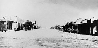
Kelton is a ghost town, just north of the Great Salt Lake, in the Park Valley area of Box Elder County, Utah, United States. The town was inhabited during the period of 1869–1942. Once an important section station on the First transcontinental railroad, Kelton was dependent on the railroad throughout its history. The town suffered serious setbacks in the 1880s when its busy stagecoach route to Boise, Idaho was discontinued, and in the 1900s when the Lucin Cutoff left it off the main rail line. The strongest earthquake in Utah history caused severe damage in 1934, but Kelton ceased to exist only when the rails were completely removed during World War II.
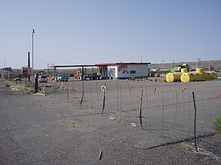
Woodside is a ghost town located on the west bank of the shallow Price River in the nearly uninhabited eastern part of Emery County, Utah, United States. Its fenced-in filling station is one of the only signs of human activity along the lonely stretch of U.S. Route 6/191 between Wellington and Green River.
Rockport is a ghost town in a narrow part of Weber Valley at the mouth of Three Mile Canyon in Summit County, Utah, United States. Located 4 miles (6.4 km) south of Wanship, it was inhabited for nearly a century before the creation of Rockport Reservoir, which covered almost the whole townsite.
Dover is a ghost town located in Sanpete County, Utah, United States. The site lies west of Fayette across the Sevier River.

Paria or Pahreah, is a ghost town on the Paria River in Grand Staircase–Escalante National Monument in central Kane County, Utah, United States. It was inhabited from 1870 to 1929, and later used as a filming location.

Widtsoe is a ghost town in Garfield County, Utah, United States. Located in John's Valley northeast of Bryce Canyon and along the Sevier River at the mouth of Sweetwater Creek, the town existed from about 1908 to 1936.
Castleton is a ghost town in the Castle Valley in southeastern Grand County, Utah, United States.

Giles is a ghost town located along the Fremont River in the Blue Valley of Wayne County, Utah, United States. The town was inhabited circa 1883–1919.
Hebron is a ghost town on Shoal Creek in Washington County in southwestern Utah, United States. Hebron was inhabited from 1862 until 1902, when the already-declining town was mostly destroyed by an earthquake. The present-day city of Enterprise, 6 miles (9.7 km) to the east, was settled largely by people leaving Hebron.

Duncan's Retreat is a ghost town located just off Utah State Route 9 in the eastern part of Washington County, in southwestern Utah, United States. Lying some 3 miles (4.8 km) east of Virgin and just southwest of Zion National Park, Duncan's Retreat was inhabited about 1861–1895.
McCornick is an unincorporated community and near-ghost town located in Millard County, Utah, United States. Lying in Whiskey Creek Flat 11 miles (18 km) northwest of Holden, McCornick was a failed land development project that lasted from 1919 until circa 1930. Today, McCornick is made up of a few scattered homes and farms.
Russian Settlement is a ghost town in the Park Valley area of Box Elder County, Utah, United States. It is not known what name, if any, the settlers from Russia gave to their community; it has been called "Box Elder County's ghost town with no name." The settlement, which lasted about 1914–1917, was formed by a group of Molokan Spiritual Christians from Russia of mixed faiths and ethnicities. The colony failed quickly because the company who sold them the land exaggerated its quality and never provided promised facilities to make the land livable. The most noticeable remnant of Russian Settlement is a cemetery with two graves.
Coal City is a ghost town in Carbon County, Utah, United States. Established in 1885, Coal City was initially a farming community until coal was discovered in the area. Small-scale mining began to take place, and because the mining operations were a mile or two away from the mines at National and Consumers, it was assumed that the citizens of the town would lack workplace stress. Coal production began to decline in 1935, and the town was essentially abandoned with just two residences occupied by the late 1960s.
Silver Reef is a ghost town in Washington County, Utah, United States, about 15 miles (24 km) northeast of St. George and 1 mile (1.6 km) west of Leeds. Silver Reef was established after John Kemple, a prospector from Nevada, discovered a vein of silver in a sandstone formation in 1866. At first, geologists were uncertain about Kemple's find because silver is not usually found in sandstone. In 1875, two bankers from Salt Lake City sent William Barbee to the site to stake mining claims. He staked 21 claims, and an influx of miners came to work Barbee's claims and to stake their own. To accommodate the miners, Barbee established a town called Bonanza City. Property values there were high, so several miners settled on a ridge to the north of it and named their settlement Rockpile. The town was renamed Silver Reef after silver mines in nearby Pioche closed and businessmen arrived.
Harrisburg is a ghost town in Washington County, Utah, United States. Established as Harrisville in 1859, the town was flooded by the Virgin River in 1862, causing the residents to move farther up Quail Creek. Soon after, the town's name was changed to Harrisburg. By 1868, 200 people lived in Harrisburg; however, over the course of the next few years, floods, Native American raids, and a grasshopper plague caused people to relocate to the nearby towns of Leeds and Silver Reef. By 1895, Harrisburg was abandoned. Presently, the site of Harrisburg is occupied by a real estate project called Harrisburg Estates, but many remnants from its old days are still visible throughout town including the historic cemetery and several sandstone houses. The neighborhood now lies within the legal boundaries of Hurricane.
Desert Lake is a ghost town in Castle Valley in northern Emery County, Utah, United States. It was inhabited from 1885 to about 1910.
Diamond is a ghost town in eastern Juab County, Utah, United States. The Diamond Cemetery is listed on the National Register of Historic Places.


