
A ZIP Code is a system of postal codes used by the United States Postal Service (USPS). Introduced on July 1, 1963, the basic format consisted of five digits. In 1983, an extended ZIP+4 code was introduced; it included the five digits of the ZIP Code, followed by a hyphen and four digits that designated a more specific location.

Medina is a city in Hennepin County, Minnesota, United States. An outer edge suburb of Minneapolis–Saint Paul, the city has a primarily rural character, with agricultural lands and natural preservation areas. Medina is home to the corporate headquarters of Polaris Inc., an automotive manufacturer that produces items such as all-terrain vehicles and snowmobiles.

Wayzata is a small lakeside city in Hennepin County, Minnesota, United States. It is about 16 miles west of Minneapolis on the shores of Lake Minnetonka. Wayzata is known for its small-town character and quaint downtown area along the lake.

Security-Widefield is a census-designated place (CDP) comprising the unincorporated communities of Security and Widefield located in and governed by El Paso County, Colorado, United States. The CDP is a part of the Colorado Springs, CO Metropolitan Statistical Area. The population of the Security-Widefield CDP was 38,639 at the United States Census 2020. El Paso County governs the unincorporated communities. Both the Colorado Springs post office and the Fountain post office serve the area.

Old Mission is an unincorporated community in Grand Traverse County in the U.S. state of Michigan. It is located within Peninsula Township near the tip of Old Mission Peninsula along the shores of the East Arm of Grand Traverse Bay. As an unincorporated community, Old Mission has no legally defined boundaries or population statistics of its own.

Bay Shore is an unincorporated community and census-designated place (CDP) located on the boundary between Charlevoix County and Emmet County in the U.S. state of Michigan. The population of the CDP was 657 at the 2020 census.

Gorham Township is one of the twelve townships of Fulton County, Ohio, United States. The 2020 census found 2,168 people in the township.
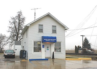
Medina is an unincorporated community in Bandera County, Texas, United States. It is part of the San Antonio Metropolitan Statistical Area. Medina is famous for its apples. The community's population was estimated to be 515 in 2000.

Weston is an unincorporated town, a post office, and a census-designated place (CDP) located in and governed by Las Animas County, Colorado, United States. The Weston post office has the ZIP Code 81091. At the United States Census 2020, the population of the Weston CDP was 53.

Homerville is an unincorporated community in central Homer Township, Medina County, Ohio, United States. It has a post office with the ZIP code 44235. It lies at the intersection of U.S. Route 224 with State Route 301.
Oil Springs is an unincorporated community in Johnson County, Kentucky, United States. It lies along Route 40 west of the city of Paintsville, the county seat of Johnson County. It has a post office with the ZIP code 41238.
Samaria is an unincorporated community in Monroe County in the U.S. state of Michigan. The community is located within Bedford Township. As an unincorporated community, Samaria has no legally defined boundaries or population statistics of its own but does have its own post office with the 48177 ZIP Code.

Medina, originally Young's Corner, is an unincorporated community in the Town of Dale in southwest Outagamie County, Wisconsin, United States. It is located 3.5 miles (5.6 km) south of the village of Hortonville, 11 miles (18 km) west of Appleton, and 20 miles (32 km) northwest of Oshkosh.
Crystal Bay is a unincorporated community in Orono, Hennepin County, Minnesota, United States. It is a farming community with many of these hobby farms having been owned by the wealthy of Minneapolis. Crystal Bay has its own post office with ZIP code 55323.
Line Lexington is an unincorporated community located in the Delaware Valley on Route 309 in Bucks and Montgomery counties in Pennsylvania, United States. It is split between the Bucks County townships of Hilltown and New Britain and the Montgomery County township of Hatfield. The Montgomery County portion of the village is in the North Penn School District and is part of the North Penn Valley region that is centered on the borough of Lansdale. The Bucks County portion is also served by the North Penn School District. While it has its own post office with the ZIP code of 18932, portions use the Colmar ZIP code of 18915, the Chalfont ZIP code of 18914 or the Hatfield ZIP code of 19440. It is served by SEPTA Suburban Bus Route 132 and the nearest SEPTA Regional Rail stations are nearby in Colmar and Chalfont on the Lansdale/Doylestown Line. The Line Lexington telephone exchange uses area code 215.

Lancaster is an unincorporated community in Smith County, Tennessee, United States, located 5.3 miles (8.5 km) southeast of Gordonsville. Lancaster had a post office with ZIP code 38569, which closed on March 4, 2011, due to the United States Postal Service closing smaller post offices around the country.

Venetia is an unincorporated community in Peters Township, Washington County, Pennsylvania, United States. It has a post office with the ZIP code 15367, covering most of the area between McMurray and Gastonville. The population of this area was 8,731 at the 2010 census. It is part of the Pittsburgh metropolitan area.

Fort Snelling is an unorganized territory of Hennepin County in the U.S. state of Minnesota. It is named after historic Fort Snelling, which is located within its boundaries. The district also includes Coldwater Spring park, Minneapolis-Saint Paul International Airport, parts of the Mississippi National River and Recreation Area, and several government facilities. As of the 2020 census the territory had a population of 322 people.
Knowlesville is a hamlet in Orleans County, New York, United States. The community is located along the Erie Canal, 4.1 miles (6.6 km) east-northeast of Medina. Knowlesville had a post office from March 11, 1826, until July 4, 2009; it still has its own ZIP code, 14479.

