
U.S. Route 74 (US 74) is an east–west United States highway that runs for 515 miles (829 km) from Chattanooga, Tennessee to Wrightsville Beach, North Carolina. Primarily in North Carolina, it serves as an important highway from the mountains to the sea, connecting the cities of Asheville, Charlotte and Wilmington. The entire length of the route is known as Andrew Jackson Highway.

Interstate 295 (I-295), also known as the Fayetteville Outer Loop, is a partially completed Interstate-grade planned 34-mile-long (55 km) bypass around the western side of Fayetteville, North Carolina, United States. As of August 2020, it stretches for 22 miles (35 km) from US Highway 401 (US 401) in western Fayetteville to I-95 and US 13 near Eastover. The final section between US 401 and I-95 near Parkton is being constructed in segments and is expected to be completed around 2026. A two-mile-long (3.2 km) segment from Parkton Road northeast of Parkton to Black Bridge Road south of Hope Mills is signed as North Carolina Highway 295 (NC 295). NC 295 was also used as temporary designations for the highway before I-295 was signed.
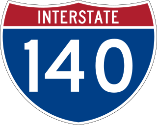
Interstate 140 (I-140) and North Carolina Highway 140 (NC 140) is a 25.4-mile (40.9 km) auxiliary Interstate Highway and state highway in the U.S. state of North Carolina. Officially designated the John Jay Burney Jr. Freeway, it serves as a bypass of Wilmington. The western terminus of the highway is at U.S. Route 17 (US 17) near Winnabow. It heads north in western Leland before turning to the east north of an interchange with U.S. Route 74 (US 74)/U.S. Route 76 (US 76). I-140 crosses the Cape Fear River north of Navassa and the Northeast Cape Fear River northwest of Wrightsboro. I-140 ends at Interstate 40 (I-40), and the route number changes to NC 140. NC 140 continues to the east, ending at US 17 in Kirkland.

Interstate 540 (I-540) and North Carolina Highway 540 (NC 540) are part of a partially completed beltway around the city of Raleigh in the US state of North Carolina, forming the Raleigh Outer Loop. When complete, the route will completely encircle the city, meeting its parent route of I-40 in two locations.

Interstate 840 (I-840) is a 21.9-mile (35.2 km) auxiliary Interstate Highway and state highway in the U.S. state of North Carolina. It is the northern half of the Greensboro Urban Loop beltway around the city of Greensboro. It connects I-40, I-73, and US 421 in the west with I-40, I-85, and I-785 in the east. It was completed on January 23, 2023.
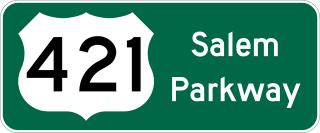
The Salem Parkway is an 18.5-mile-long (29.8 km) freeway in the U.S. state of North Carolina, serving the city of Winston-Salem and the town of Kernersville. It is signed as U.S. Route 421 (US 421) for its entire length, though it is also concurrent with US 158 in downtown Winston-Salem and North Carolina Highway 150 (NC 150) between Winston-Salem and Kernersville. Originally known as the East–West Expressway, it was designated as part of Interstate 40 (I-40) and opened in 1958, becoming the first section of Interstate Highway in the state. I-40 was rerouted onto a new alignment bypassing Winston-Salem and Kernersville in 1992, at which time the road was designated Interstate 40 Business, nicknamed Business 40.
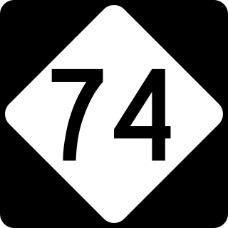
The Winston-Salem Northern Beltway is a partially completed freeway loop around the city of Winston-Salem in North Carolina. The western section has been designated as North Carolina Highway 452 (NC 452), which will become I-274 when completed, and the eastern section of the beltway will be designated as North Carolina Highway 74 (NC 74), which will become part of I-74 when completed. The entire route is in Forsyth County.
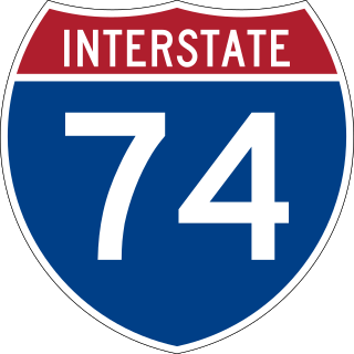
Interstate 74 (I-74) is a partially completed part of the Interstate Highway System that is planned to run from Davenport, Iowa, to Myrtle Beach, South Carolina. In the US state of North Carolina, I-74 currently exists in three distinct segments; from I-77 at the Virginia state line to US Highway 52 (US 52) near Mount Airy, from I-40 in Winston-Salem to US 220 near Ellerbe, and from US 74 and US 74 Business near Maxton to US 74/North Carolina Highway 41 (NC 41) near Lumberton. I-74 has an extensive concurrency with I-73 from Randleman to Ellerbe in the Piedmont. When completed, I-74 will link the cities of Mount Airy, Winston-Salem, High Point, Rockingham, Laurinburg, and Lumberton.

Interstate 40 (I-40) is a part of the Interstate Highway System that travels 2,556.61 miles (4,114.46 km) from Barstow, California, to Wilmington, North Carolina. In North Carolina, I-40 travels 420.21 miles (676.26 km) across the entirety of the state from the Tennessee state line along the Pigeon River Gorge to U.S. Highway 117 (US 117) and North Carolina Highway 132 (NC 132) in Wilmington. I-40 is the longest Interstate Highway in North Carolina and is the only Interstate to completely span the state from west to east.
Interstate 73 (I-73) is a partially completed Interstate Highway in the US state of North Carolina, traversing the state from south of Ellerbe to near Summerfield through Asheboro and Greensboro. When completed, it will continue south toward Myrtle Beach, South Carolina, and north to Martinsville, Virginia.

U.S. Route 70 Bypass is a bypass route of US 70 in North Carolina that runs west of Goldsboro to La Grange. Formerly known as North Carolina Highway 44 (NC 44) from 2011 to 2016, its current designation is also only temporary as it will become part of Interstate 42 (I-42).
U.S. Route 70 (US 70) is a part of the United States Numbered Highway System that runs from Globe, Arizona, to the Crystal Coast of the US state of North Carolina. In North Carolina, it is a major 488-mile-long (785 km) east–west highway that runs from the Tennessee border to the Atlantic Ocean. From the Tennessee state line near Paint Rock to Asheville it follows the historic Dixie Highway, running concurrently with US 25. The highway connects several major cities including Asheville, High Point, Greensboro, Durham, Raleigh, Goldsboro, and New Bern. From Beaufort on east, US 70 shares part of the Outer Banks Scenic Byway, a National Scenic Byway, before ending in the community of Atlantic, located along Core Sound.

Interstate 795 (I-795) is a 25.49-mile (41.02 km) auxiliary Interstate Highway in the US state of North Carolina. It connects the city of Goldsboro to I-95 just south of Wilson, paralleling the northern portion of US Route 117 (US 117). The road runs a five-mile (8.0 km) concurrency with US 264 and I-587 in the last section of the route. It serves as a primary freeway spur for the city of Goldsboro to the Interstate Highway System, as well part of a major cargo route for the cities of Down East, which was a part of the impetus for its designation in 2007.

U.S. Highway 1 (US 1) is a north–south United States Numbered Highway which runs along the East Coast of the U.S. between Key West, Florida, and the Canada–United States border near Fort Kent, Maine. In North Carolina, US 1 runs for 174.1 miles (280.2 km) across the central region of the state. The highway enters North Carolina from South Carolina, southwest of Rockingham. US 1 runs northeast, passing through or closely bypassing Southern Pines and Sanford in the Sandhills region. It next passes through Cary, the state capital of Raleigh, and Wake Forest. The highway continues north to Henderson, before leaving the state at the Virginia state line, near Wise. The route is mostly a multilane divided arterial road, with several freeway segments. It serves as a strategic highway, connecting the North Carolina Sandhills and Research Triangle regions northward to the Southside region.

U.S. Highway 76 (US 76) is a U.S. Highway running from Chattanooga, Tennessee to Wrightsville Beach, North Carolina. In North Carolina the highway runs for 80.4 miles (129.4 km) in the southeastern region of the state. US 76 enters the state from South Carolina south of Fair Bluff in Columbus County. Travelling in an eastward direction, US 76 meets US 74 in Chadbourn. The two highways run concurrently for 50.4 miles (81.1 km) between Chadbourn and Wilmington. US 76 runs concurrently with US 17 along much of its Wilmington routing, until once again meeting US 74. US 76 and US 74 run concurrently for 1.4 miles (2.3 km) until reaching Wrightsville Beach. US 76 reaches its eastern terminus on the south side of Wrightsville Beach, at an intersection with Water Street.
Several special routes of U.S. Route 74 exist. In order from west to east they are as follows.
The Monroe Expressway, designated U.S. Route 74 Bypass, is a 18.68-mile (30.06 km) controlled-access toll road in Union County in the U.S. state of North Carolina, the first to be completed in the Charlotte area. It serves as a bypass of the communities of Indian Trail, Monroe, and Wingate for U.S. Route 74 (US 74), running generally parallel to the route.

North Carolina Highway 11 Bypass, is a 17.9-mile (28.8 km), bypass route of NC 11 in Pitt County, North Carolina. The bypass is a four-lane freeway that runs between a junction with NC 11 south of Ayden to an interchange with U.S. Route 264 (US 264), US 13, NC 11, and NC 903 north of Greenville, wrapping around the west side of Ayden and Winterville and the northwest side of Greenville. The southern 12.6 miles (20.3 km) of the route is known as the Greenville Southwest Bypass to locals, which was built due to plans relating traffic alleviation the NC 11 and Stantonsburg Road corridors. The remaining 6.8-mile (10.9 km) segment of the route is concurrent with US 264.

Interstate 885 (I-885) and North Carolina Highway 885 (NC 885) is an 11.5-mile (18.5 km) auxiliary Interstate Highway and state highway in the U.S. state of North Carolina. It links NC 540 and I-40 to I-85 in the Durham area. The route consists of two previously preexisting segments of freeway—NC 147 to the south and US 70 to the north—connected by the East End Connector, which opened to traffic on June 30, 2022.
The Shelby Bypass, planned to be designated as U.S. Route 74 Bypass, is a future 18.5-mile (29.8 km) four-lane freeway bypass of the city of Shelby along U.S. Route 74 (US 74) in Cleveland County in the U.S. state of North Carolina. It will begin at a trumpet interchange with US 74 west of Shelby, running along its northern city limits, before terminating at another trumpet interchange with US 74 on the southeast city limits of Shelby. The project will also include upgrading a stretch of US 74 from the eastern Shelby Bypass interchange to the diamond interchange with U.S. Route 74 Business just west of Kings Mountain. The bypass is currently under construction in six sections and is currently expected to be fully open to traffic in 2024.


