Lake Champlain is a natural freshwater lake in North America. It mostly lies between the US states of New York and Vermont, but also extends north into the Canadian province of Quebec.
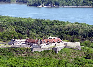
Fort Ticonderoga, formerly Fort Carillon, is a large 18th-century star fort built by the French at a narrows near the south end of Lake Champlain, in northern New York, in the United States. It was constructed by Canadian-born French military engineer Michel Chartier de Lotbinière, Marquis de Lotbinière between October 1755 and 1757, during the action in the "North American theater" of the Seven Years' War, often referred to in the US as the French and Indian War. The fort was of strategic importance during the 18th-century colonial conflicts between Great Britain and France, and again played an important role during the Revolutionary War.

The Battle of Valcour Island, also known as the Battle of Valcour Bay, was a naval engagement that took place on October 11, 1776, on Lake Champlain. The main action took place in Valcour Bay, a narrow strait between the New York mainland and Valcour Island. The battle is generally regarded as one of the first naval battles of the American Revolutionary War, and one of the first fought by the United States Navy. Most of the ships in the American fleet under the command of Benedict Arnold were captured or destroyed by a British force under the overall direction of General Guy Carleton. However, the American defense of Lake Champlain stalled British plans to reach the upper Hudson River valley.

Crown Point is a town in Essex County, New York, United States, located on the west shore of Lake Champlain. The population was 2,024 at the 2010 census. The name of the town is a direct translation of the original French name, Pointe à la Chevelure.

Ticonderoga is a town in Essex County, New York, United States. The population was 5,042 at the 2010 census. The name comes from the Mohawk tekontaró:ken, meaning "it is at the junction of two waterways".

Orwell is a town in Addison County, Vermont, United States. The population was 1,239 at the 2020 census. Mount Independence was the largest fortification constructed by the American colonial forces. The 300-acre (1.2 km2) site is now one of Vermont's premier state-operated historic sites.

Shoreham is a town in Addison County, Vermont, United States. The population was 1,260 at the 2020 census.

The capture of Fort Ticonderoga occurred during the American Revolutionary War on May 10, 1775, when a small force of Green Mountain Boys led by Ethan Allen and Colonel Benedict Arnold surprised and captured the fort's small British garrison. The cannons and other armaments at Fort Ticonderoga were later transported to Boston by Colonel Henry Knox in the noble train of artillery and used to fortify Dorchester Heights and break the standoff at the siege of Boston.

Ticonderoga is a hamlet in the southeast part of the town of Ticonderoga, in Essex County, New York, United States. The name is derived from the Haudenosaunee term for "between the two waters", the two waters being Lake George and Lake Champlain. The hamlet became a census-designated place (CDP) in 2008. As of the 2010 census, the population was 3,382, out of a total 5,042 residents in the town of Ticonderoga.

Seth Warner was an American soldier. He was a Revolutionary War officer from Vermont who rose to rank of Continental colonel and was often given the duties of a brigade commander. He is best known for his leadership in the capture of Fort Crown Point, the Battle of Longueuil, the siege of Quebec, the retreat from Canada, and the battles of Hubbardton and Bennington.
Chimney Point is a peninsula in the town of Addison, Vermont, which juts into Lake Champlain forming a narrows. It is one of the earliest settled and most strategic sites in the Champlain Valley.

The steamboat Ticonderoga is one of two remaining side-paddle-wheel passenger steamers with a vertical beam engine of the type that provided freight and passenger service on America's bays, lakes and rivers from the early 19th to the mid-20th centuries. Commissioned by the Champlain Transportation Company, Ticonderoga was built in 1906 at the Shelburne Shipyard in Shelburne, Vermont on Lake Champlain.

Fort Halifax is a former British colonial outpost on the banks of the Sebasticook River, just above its mouth at the Kennebec River, in Winslow, Maine. Originally built as a wooden palisaded fort in 1754, during the French and Indian War, only a single blockhouse survives. The oldest blockhouse in the United States, it is preserved as Fort Halifax State Historic Site, and is open to the public in the warmer months. The fort guarded Wabanaki canoe routes that reached to the St. Lawrence and Penobscot Valleys via the Chaudière-Kennebec and Sebasticook-Souadabscook rivers. The blockhouse was declared a National Historic Landmark and added to the National Register of Historic Places in 1968.

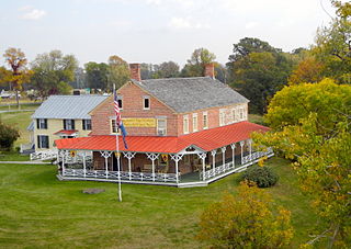
Mount Independence on Lake Champlain in Orwell, Vermont, was the site of extensive fortifications built during the American Revolutionary War by the American army to stop a British invasion. Construction began in July 1776, following the American defeat in Canada, and continued through the winter and spring of 1777. After the American retreat on July 5 and 6, 1777, British and Hessian troops occupied Mount Independence until November 1777.

USS Philadelphia is a gunboat of the Continental Navy. She was constructed from July–August 1776 for service during the American Revolutionary War. Manned by Continental Army soldiers, she was part of a fleet under the command of General Benedict Arnold that fought against the British Royal Navy in the Battle of Valcour Island on Lake Champlain. Philadelphia was sunk during the battle on 11 October 1776.
USS Spitfire was an American gundalow that operated as a gunboat in 1776 on Lake Champlain. She was part of Benedict Arnold's small, hastily built fleet of ships whose purpose was to counter any British invasion forces passing through the lake from Canada. Her service life was brief; after only a few months patrolling the lake she was lost in the aftermath of the Battle of Valcour Island. The gunboat's wreck was located and documented in the 1990s by the Lake Champlain Maritime Museum.

The Crown Point Road, or the Crown Point Military Road, is a historic road built in 1759-60, mostly in what is now the United States state of Vermont. It was built by British Army and colonial militia forces to connect Fort Crown Point near the southern end of Lake Champlain to the Fort at Number 4 in what is now Charlestown, New Hampshire. It was the first major road in Vermont, spurring development along its route after the French and Indian War. Fragments of the road are still visible in largely period condition, or have been paved over, while others have disappeared into the forest. Sections of the road located in Weathersfield have been listed on the National Register of Historic Places.

Whitehall is a village located in the town of Whitehall in Washington County, New York, United States. It is part of the Glens Falls Metropolitan Statistical Area. The village population was 2,614 in 2010.

The Fort Vengeance Monument Site is an archaeological and commemorative site on United States Route 7 in northern Pittsford, Vermont. The site includes the archaeological remains of one of Vermont's oldest documented homesteads, and the only surviving site of a military fortification of the American Revolutionary War. The site is marked by a stone memorial placed in 1873, and was listed on the National Register of Historic Places in 2006.
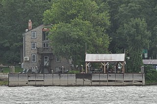
The Larrabee's Point Complex consists of a collection of ferry-related buildings and structures at the western end of Vermont Route 74 in Shoreham, Vermont. Included are facilities currently used by the oldest operating ferry on Lake Champlain, the Ticonderoga-Larrabees Point Ferry, and two buildings historically associated with the ferry operation. The complex was listed on the National Register of Historic Places in 1980.