
The Piccadilly line is a deep-level London Underground line running between the west and the north of London. It has two western branches which split at Acton Town and serves 53 stations. The line serves Heathrow Airport, and some of its stations are near tourist attractions in Central London such as Piccadilly Circus and Buckingham Palace. The District and Metropolitan lines share some sections of track with the Piccadilly line. Printed in dark blue on the Tube map, it is the sixth-busiest line on the Underground network, with nearly 218 million passenger journeys in 2019.
The London Borough of Ealing is a London borough in London, England. It comprises the districts of Acton, Ealing, Greenford, Hanwell, Northolt, Perivale and Southall. With a population of 367,100 inhabitants, it is the third most populous London borough.

Perivale is a mainly residential suburban town of Greater London, 9.5 miles (15.3 km) west of Charing Cross. It is the smallest of the seven towns which make up the London Borough of Ealing.
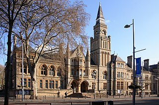
Ealing is a district in west London, England, 7.5 miles (12.1 km) west of Charing Cross in the London Borough of Ealing. It is the administrative centre of the borough and is identified as a major metropolitan centre in the London Plan.
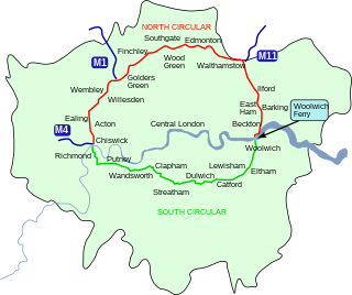
The North Circular Road is a 25.7-mile-long (41.4 km) ring road around Central London. It runs from Chiswick in the west to Woolwich in the east via suburban north London, connecting various suburbs and other trunk roads in the region.

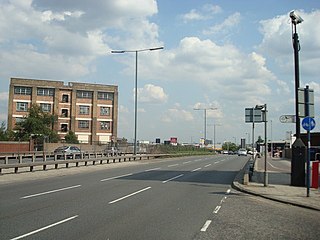
The Hanger Lane gyratory is a multi-lane rectangular gyratory – having the Hanger Lane underpass, under its southern limb, for the Western Avenue (A40). It enables intersection with the North Circular (A406) and the inceptive Ealing Road towards Wembley. It is in the north of the borough of Ealing in west London.
Western Avenue is part of the A40, a major road running in a north-westerly direction out of London. Western Avenue is approximately 10 miles (16 km) long from its junction with Old Oak Common Lane in East Acton.

Hanger Lane is a London Underground station in Hanger Hill, Ealing, on the border between West and Northwest London. It is located on the West Ruislip branch of the Central line, between Perivale and North Acton stations, and is in Travelcard Zone 3.
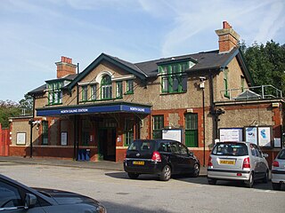
North Ealing is a London Underground station on the Uxbridge branch of the Piccadilly line between Park Royal and Ealing Common stations. The station is located on Station Road, a short distance from the junction of Queen's Drive and Hanger Lane. It is in Travelcard Zone 3. West Acton station on the Central line is located about 550 metres to the east at the other end of Queen's Drive.

Park Royal is an area in Northwest London, England, divided between the London Borough of Ealing and the London Borough of Brent.

Ealing Common is a large open space in Ealing, West London.

The A202 is a primary A road in London. It runs from New Cross Gate to London Victoria station. A section of the route forms a part of the London Inner Ring Road between Vauxhall and Victoria, known as Vauxhall Bridge Road.
West Twyford is a small residential area forming a northeastern corner of the London Borough of Ealing directly northeast of Hanger Lane station and north of Park Royal, south of the London Borough of Brent and the River Brent. It was historically an extra-parochial area, then civil parish (1866-1926), in Middlesex, England.

The A40 is a major trunk road connecting London to Fishguard, Wales. The A40 in London starts in the City of London and passes through six London Boroughs: Camden, Westminster, Kensington & Chelsea, Hammersmith & Fulham, Ealing and Hillingdon, to meet the M40 motorway junction 1 at Denham, Buckinghamshire.

The Acton–Northolt line (ANL), otherwise known as the New North Main Line (NNML), is a railway line in West London, England. Built between 1903 and 1906, it runs from the Great Western Main Line at Old Oak Common TMD to the Chiltern Main Line at South Ruislip, alongside the West Ruislip branch of the London Underground Central line, for a distance of around 11 miles (18 km).

Hanger Hill or Haymills Estate is a local area of the London Borough of Ealing around Hanger Lane. It was developed in the interwar period when affluent Londoners began to move out of Central London for more green spaces. The estate features spacious houses and flats designed by architects Douglas Smith and Barley.

Fox Wood is a 2.25 hectare Local Nature Reserve and Site of Borough Importance for Nature Conservation, Grade 1, in Ealing in the London Borough of Ealing. It is owned and managed by Ealing Council.

Gypsy Corner is the junction of the A40 road with the A4000 road in North Acton, West London.
Twyford Abbey Halt was a short-lived railway station in Park Royal, Ealing, London on the New North Main Line and was located between Perivale Halt and Park Royal West Halt. It opened on 1 May 1904 and closed on 1 May 1911 when it was replaced by Brentham for North Ealing and Greystoke Park. The station was close to the location of the London Underground's Hanger Lane which opened in 1947.

Hanger Hill Wood is a small remnant of ancient woodland to the east of the Hanger Hill Park and North Circular Road at Hanger Lane, in Ealing in the London Borough of Ealing. Named from 'Hangra', the Old English word for wooded slope. There is access from Hanger Lane, alternative access is at several points on Chatsworth Road.


