A40 road in London

Last updated

UK road A40.svg
A40
Route information
HistoryConstructed 1920s–1992
Major junctions
East end City of London
Major intersectionsA1
UK road A201.svg A201
A4
UK road A5200.svg A5200
UK road A4200.svg A4200
UK road A401.svg A401
UK road A400.svg A400
UK road A4201.svg A4201
A41
UK road A4202.svg A4202
UK road A402.svg A402
A5
UK road A501.svg A501
UK road A404.svg A404
UK road A3220.svg A3220
UK road A219.svg A219
UK road A4000.svg A4000
UK road A406.svg A406
UK road A4127.svg A4127
UK road A312.svg A312
UK road A4180.svg A4180
UK road A437.svg A437
UK-Motorway-M40.svg M40
West end Denham Roundabout
Location
Country United Kingdom
Constituent country England
Primary
destinations

M40
M25
Road network

The A40 is a major trunk road connecting London to Fishguard, Wales. The A40 in London passes through seven London Boroughs: the City of London, Camden, Westminster, Kensington & Chelsea, Hammersmith & Fulham, Ealing and Hillingdon, to meet the M40 motorway junction 1 at Denham, Buckinghamshire.

Contents

The road has been re-routed several times in the last 100 years part of the route of the London section of the A40 was laid out in the 1920s and 1930s when Western Avenue was built now most of it is grade-separated, dual carriageway (divided highway). In the 1960s Westway was constructed, easing traffic access to and from the centre of the city. The A40 links the City of London and the West End to the M40 motorway and M25 motorway. The route is called The London to Fishguard Trunk Road (A40) in legal documents and acts.

City of London City of Westminster

The A40 officially starts where St. Martin's Le Grand meets Cheapside. Here it shares a terminus with the A1, the main north London radial. First forming Newgate Street and then through Holborn to Holborn Viaduct. This viaduct carries the A40 over the A201 (leading to Blackfriars Bridge) and on to Holborn Circus where the A40 crosses the terminus of the A4. The A40 here is named High Holborn. One of the four Inns of Court, Gray's Inn, is on the north side of the road. Another, Lincoln's Inn, is on the south side. The road is now in the Borough of Camden. Leaving Holborn, the A40 crosses into the City of Westminster, forming New Oxford Street. The British Museum is close at this point. After crossing the southern end of Tottenham Court Road (the A400) at St Giles Circus, the A40 becomes Oxford Street.

Oxford Circus - as it was in March 2006 - looking down Regent Street which crosses Oxford Street. Under Oxford Circus is one of the busiest of London's underground stations. The Central, Bakerloo and Victoria lines all meet here. The Circus was constructed in the beginning of the 19th century, and was designed by John Nash Oxford Circus Panorama March 2006.jpg
Oxford Circus  as it was in March 2006 looking down Regent Street which crosses Oxford Street. Under Oxford Circus is one of the busiest of London's underground stations. The Central, Bakerloo and Victoria lines all meet here. The Circus was constructed in the beginning of the 19th century, and was designed by John Nash

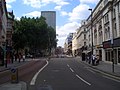
Oxford Street is Europe's busiest shopping street. Many chain stores have their flagship store on the street, including John Lewis, Debenhams, Marks and Spencers, House of Fraser and Selfridges. There are several tube stations along the road: the Central line runs under Oxford Street and is London Underground's second busiest line with 180 million passengers a year. The busiest stations are Tottenham Court Road, Oxford Circus, and Bond Street, which provide access to five tube lines. The road forms the northern boundary of Soho; the main theatres and cinemas are located to the south near Leicester Square. The area contains a large number of clubs, bars and music venues; Wigmore Hall on Wigmore Street is a notable example. Centre Point was one of London's first skyscrapers. The A40 continues as Oxford Street to Marble Arch at the north-east corner of Hyde Park. Nearby is Speakers' Corner, where people are generally allowed considerable freedom of speech, although the police occasionally intervene. Nearby is the site of Tyburn gallows, where public executions took place from 1388 to 1793. At Marble Arch is a major road junction of Oxford Street, Park Lane (A4202), Bayswater Road (A402) and Edgware Road (A5). The A40 has taken three courses from here over the last thirty years. The last change was in 2000, when Westway lost its motorway status (A40(M)) and became the A40.

Now that Westway is part of the A40, the road no longer follows its western route from the Marble Arch roundabout. To continue on the A40 from Oxford Street, turn northwards into Portman Street (A41) which continues as Gloucester Place  to join the London Inner Ring Road to the west of Baker Street Underground station. Turning left onto the A501 (Marylebone Road) links with the Marylebone Flyover and the start of Westway.
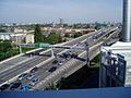
Westway

Westway is a 3.5-mile (5.6 km) long, elevated dual carriageway section of the A40 in west London. It runs from Paddington to North Kensington. It was constructed between 1964 and 1970 to relieve congestion at Shepherd's Bush, with traffic from Western Avenue struggling to enter central London along too narrow roads. Opening in July 1970, Westway was designated A40(M) . Retaining its hard shoulders and including both four-lane and six-lane sections, it still resembles a motorway. In 2000, when responsibility for trunk roads in Greater London was transferred from the Highways Agency to the Greater London Authority, Westway lost its motorway status.

The construction of Westway caused major disruption, with the demolition of houses and roads. When opened it was the largest continuous concrete structure in Britain.

Route

Westway starts from the Marylebone Flyover. Here the Marylebone Road (A501) part of the northern section of the London Inner Ring Road   crosses the Edgware Road (A5) and continues as the A40 It runs close to the Great Western Main Line out of Paddington to join Western Avenue.

Between the Marylebone Flyover and Westway, a 100-metre section of surface-level road allows westbound traffic from the Marylebone Flyover to exit towards the Harrow Road (A404) and eastbound traffic from the Harrow Road to access the Flyover. Eastbound traffic from the Westway cannot exit here to reach the Edgware Road and must continue ahead to the Marylebone Flyover.

After passing Paddington Basin and Paddington station and crossing the Paddington branch of the Grand Union Canal, Westway follows the Hammersmith & City line through North Kensington and Westbourne Green passing three London Underground stations (Royal Oak, Westbourne Park and Ladbroke Grove) before flowing into Western Avenue.

Background

Leaving Marble Arch, the A40 continued along Bayswater Road and Holland Park Avenue (now the A402) running through Notting Hill Gate to Shepherd's Bush. Before Western Avenue was proposed and completed, the A40 continued along the Uxbridge Road (the present A4020) passing through Ealing, Southall, Uxbridge and Denham, Buckinghamshire. Still busy, the Uxbridge Road was redesignated the A4020, when Western Avenue was changed from being the A403, and the A40 route changed accordingly,

From Shepherd's Bush, the A40 moved northbound along Wood Lane  near the BBC Television Centre  to join Western Avenue adjacent to a roundabout with the M41, now the A3220, also referred to as the West Cross Route. The M41 and the A40(M) were downgraded to the A3220 and A40 at the same time in 2000.

Western Avenue

Starting at the junction with Old Oak Common Lane and Old Oak Road, East Acton, Western Avenue is approximately 10 miles (16 km) long. This junction is traffic light controlled, but its name 'Savoy Circus' recalls the roundabout which once formed the junction. From this point the A40 swings in a north-westerly direction towards North Acton, crosses the Great Western Main Line, and the final traffic light controlled junction known as 'Gypsy Corner' (A4000), to arrive at the Hanger Lane Gyratory System to connect with the A406 and A4005. The A40 passes under the gyratory system in a tunnel.

Denham Roundabout

The Denham Roundabout is where Western Avenue   A40  flows into the M40 motorway. The roundabout below provides a connection with the westbound continuation of the A40, together with the intersection of the road from Uxbridge (A4020) and the road from Slough to Watford (A412).

When the M40 from Denham to High Wycombe was built, Western Avenue was extended at high level to make an end-on join with the motorway, and a larger roundabout was built below the bridges carrying the motorway. When first laid out, the roundabout had the traffic going round it clockwise in the usual way, but as traffic volumes built up the layout was altered so that the traffic moved round the roundabout in both directions making it almost a ring road with mini-roundabouts at the points where other roads join the main roundabout.

Part of a larger plan

Plan of the London Motorway Box scheme from mid-1960s showing the West Cross Route as built and as planned London Motorway Box 1960s Plan.png
Plan of the London Motorway Box scheme from mid-1960s showing the West Cross Route as built and as planned

The West Cross Route in The Royal Borough of Kensington and Chelsea and the Hammersmith and Fulham borough, was formerly the M41 motorway, part of the innermost circuit of the London Ringways network a complex and comprehensive plan for a network of high-speed roads circling central London. Designed to manage and control the flow of traffic within the capital, the road would have run from Battersea to Harlesden and would have paralleled the National Rail West London Line as an elevated road. Opening in 1970, together with Westway, it runs north–south between the northern elevated roundabout junction with the western end of the Westway (A40) and the southern Holland Park Roundabout.

In 2000 its status was downgraded to an A-road  a short, 0.75 miles (1.21 km) dual carriageway section of the A3220.

Westfield

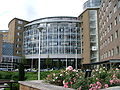
A grade-separated junction was built approximately halfway along this section of the A3220 in 2008 to connect to the Westfield London shopping development. This shopping precinct in White City (London Borough of Hammersmith and Fulham) is on a site bounded by the West Cross Route, Westway and Wood Lane (A219), and opened on 30 October 2008. [1]

Related Research Articles

<span class="mw-page-title-main">Paddington</span> Area of central London, England

Paddington is an area in the City of Westminster, in central London, England. A medieval parish then a metropolitan borough, it was integrated with Westminster and Greater London in 1965. Paddington station, designed by the engineer Isambard Kingdom Brunel opened in 1847. It is also the site of St Mary's Hospital and the former Paddington Green Police Station.

<span class="mw-page-title-main">London Inner Ring Road</span> Major roads that encircle the centremost part of London

The London Inner Ring Road, or Ring Road as signposted, is a 12-mile (19 km) route with an average diameter of 2.75–5.5 miles (4.43–8.85 km) formed from a number of major roads that encircle Central London. The ring road forms the boundary of the London congestion charge zone, although the ring road itself is not part of the zone.

<span class="mw-page-title-main">Marylebone Road</span>

Marylebone Road is an important thoroughfare in central London, within the City of Westminster. It runs east–west from the Euston Road at Regent's Park to the A40 Westway at Paddington. The road which runs in three lanes in both directions, is part of the London Inner Ring Road and as such forms part of the boundary of the zone within which the London congestion charge applies.

<span class="mw-page-title-main">M40 motorway</span> British motorway connecting London and Birmingham

The M40 motorway links London, Oxford, and Birmingham in England, a distance of approximately 89 miles (143 km).

<span class="mw-page-title-main">Edgware Road</span> Road in London, England

Edgware Road is a major road in London, England. The route originated as part of Roman Watling Street and, unusually in London, it runs for 10 miles in an almost perfectly straight line. Forming part of the modern A5 road, Edgware Road undergoes several name changes along its length, including Maida Vale, Kilburn High Road, Shoot Up Hill and Cricklewood Broadway; but the road is, as a whole, known as the Edgware Road, as it is the road to Edgware.

<span class="mw-page-title-main">Shepherd's Bush</span> District of West London, England

Shepherd's Bush is a district of West London, England, within the London Borough of Hammersmith and Fulham 4.9 miles (7.9 km) west of Charing Cross, and identified as a major metropolitan centre in the London Plan.

<span class="mw-page-title-main">A40 road</span> Road in Great Britain, connecting London to Wales

The A40 is a trunk road which runs between London and Goodwick (Fishguard), Wales, and officially called The London to Fishguard Trunk Road (A40) in all legal documents and Acts. Much of its length within England has been superseded by motorways, such as the M40, and has lost its trunk road status, though it retains it west of Gloucester, including its length within Wales. It is approximately 260 miles (420 km) long. The eastern section from Denham, Buckinghamshire to Wheatley, Oxfordshire is better served by the M40 and its former function of linking London with Cheltenham and Gloucester has been taken by the M4, A419 and A417 via Swindon.

<span class="mw-page-title-main">Westway (London)</span> Elevated dual carriageway section of A40 road in West London

The Westway is a 2.5-mile (4 km) elevated dual carriageway section of the A40 trunk road in West London running from Paddington in the east to North Kensington in the west. It connects the London Inner Ring Road to the West London suburbs.

<span class="mw-page-title-main">A4 road (England)</span> Major road in England

The A4 is a major road in England from Central London to Avonmouth via Heathrow Airport, Reading, Bath and Bristol. It is historically known as the Bath Road with newer sections including the Great West Road and Portway. The road was once the main route from London to Bath, Bristol and the west of England and formed, after the A40, the second main western artery from London.

<span class="mw-page-title-main">North Circular Road</span> Ring road around Central London, England

The North Circular Road is a 25.7-mile-long (41.4 km) ring road around Central London in England. It runs from Chiswick in the west to Woolwich in the east via suburban North London, connecting various suburbs and other trunk roads in the region. Together with its counterpart, the A205 South Circular Road, it forms a ring road around central London. This ring road does not make a complete circuit of the city, being C-shaped rather than a complete loop as the crossing of the River Thames in the east is made on the Woolwich Ferry.

<span class="mw-page-title-main">Latimer Road tube station</span> London Underground station

Latimer Road is a London Underground station in North Kensington, in the Royal Borough of Kensington and Chelsea. It is on the Circle and Hammersmith & City lines between Wood Lane and Ladbroke Grove stations and is in Travelcard Zone 2.

<span class="mw-page-title-main">Western Avenue, London</span> Major road in Greater London, UK

Western Avenue is part of the A40, a major road running in a north-westerly direction out of London. Western Avenue is approximately 10 miles (16 km) long from its junction with Old Oak Common Lane in East Acton.

<span class="mw-page-title-main">Denham Roundabout</span> Traffic roundabout in Buckinghamshire, England

The Denham Roundabout is a road junction in Denham, Buckinghamshire. The westbound A40, flows into the M40 motorway at this point. The roundabout below facilitates junction 1 (J1) of the motorway to connect with the westbound continuation of the A40, together with the intersection of the road from Uxbridge (A4020) and the road from Slough to Watford (A412).

<span class="mw-page-title-main">West Cross Route</span> Dual carriageway section of the A3220 route in central London

The West Cross Route (WCR) is a 0.75 mile segment of dual carriageway of the A3220 route in West London running north–south between the northern elevated roundabout junction with the western end of Westway (A40) and the southern Holland Park Roundabout. It runs through Shepherd's Bush to its west and Notting Hill to its east.

<span class="mw-page-title-main">East Cross Route</span> Road in East London

East Cross Route (ECR) is a dual-carriageway road constructed in east London as part of the uncompleted Ringway 1 as part of the London Ringways plan drawn up the 1960s to create a series of high speed roads circling and radiating out from central London. The road was constructed between 1967 and 1973 and runs from Hackney Wick in north-east London, through the Blackwall Tunnel, to Kidbrooke in south-east London. The ECR was initially designated as part of the A102, but has, subsequently, been partially renumbered so that sections of it are now the A2 and A12.

<span class="mw-page-title-main">Edgware Road tube station (Bakerloo line)</span> London Underground station on the Bakerloo line

Edgware Road is a London Underground station on the Bakerloo line, located in the City of Westminster. It is between Paddington and Marylebone stations on the line and falls within Travelcard zone 1. The station is located on the north-east corner of the junction of Edgware Road, Harrow Road and Marylebone Road. It is adjacent to the Marylebone flyover.

<span class="mw-page-title-main">A3220 road</span> Road in west London

The A3220 is a primary A road in London. It runs north from Clapham Common to the A40 Westway at Ladbroke Grove.

The Great Western and Great Central Joint Railway was a railway built and operated jointly by the Great Western Railway (GWR) and Great Central Railway (GCR) between Northolt and Ashendon Junction. It was laid out as a trunk route with gentle curves and gradients and spacious track layouts. The two companies each needed approach railways at both ends of the line to connect their respective systems; these were built as part of a single project.

<span class="mw-page-title-main">New Road, London</span> Historic London road

The New Road was a toll road built across fields around the northern boundaries of London, the first part of which opened in 1756. The route comprises the modern-day A501.

<span class="mw-page-title-main">Royal Commission on London Traffic</span> Former royal commission of the United Kingdom

The Royal Commission on London Traffic was a Royal commission established in 1903 with a remit to review and report on how transport systems should be developed for London and the surrounding area. It produced a report in eight volumes published in 1905 and made recommendations on the character, administration and routing of traffic in London.

References

  1. "Enormous shopping complex opens". BBC. 30 October 2008. Retrieved 30 October 2008.

Coordinates: 51°30′55″N0°05′54″W / 51.5153°N 0.0983°W / 51.5153; -0.0983