
Porirua, a city in the Wellington Region of the North Island of New Zealand, is one of the four cities that constitute the Wellington metropolitan area. The name 'Porirua' is a corruption of 'Pari-rua', meaning "the tide sweeping up both reaches". It almost completely surrounds Porirua Harbour at the southern end of the Kāpiti Coast. As of 2023, Porirua has a population of 62,400 people, and is a diverse city with 26.5% of the population identifying as Pasifika and 23.0% of the population identifying as Māori.

Greater Wellington, also known as the Wellington Region, is a non-unitary region of New Zealand that occupies the southernmost part of the North Island. The region covers an area of 8,049 square kilometres (3,108 sq mi), and has a population of 550,500.

The Kāpiti Coast District, is a local government district of the Wellington Region in the lower North Island of New Zealand, 50 km north of Wellington City. The district is named after Kapiti Island, a prominent island 5 kilometres (3.1 mi) offshore.

Wellington City Council is a territorial authority in New Zealand, governing the city of Wellington, the country's capital city and third-largest city by population, behind Auckland and Christchurch. It consists of the central historic town and certain additional areas within the Wellington metropolitan area, extending as far north as Linden and covering rural areas such as Mākara and Ohariu. The city adjoins Porirua in the north and Hutt City in the north-east. It is one of nine territorial authorities in the Wellington Region.

The South Wairarapa District is a district at the south-east tip of the North Island of New Zealand, governed by the South Wairarapa District Council. The district comprises the southernmost part of the Wairarapa, and is part of the Wellington Region.

Wainuiomata is a large dormitory suburb of Lower Hutt, in the Wellington metropolitan area in New Zealand. Its population was estimated as being 19,840 as of June 2023, with a density of 1,600 people per km2. European settlement of Wainuiomata began in the 1850s with timber-felling and farming and began to grow in the 1920s. After World War 2 there was rapid population expansion, with Wainuiomata earning the nickname 'Nappy Valley' because of the large number of families with young children. From the late 1980s the economy slowed and the population decreased, but since about 2020 there has been a housing boom and corresponding increase in population. Wainuiomata is noted for being the origin of New Zealand's kōhanga reo movement.

The suburb of Plimmerton lies in the northwest part of the city of Porirua in New Zealand, adjacent to some of the city's more congenial beaches. State Highway 59 and the North Island Main Trunk railway line pass just east of the main shopping and residential area.

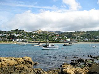
Pukerua Bay is a small seaside suburb at the southern end of the Kāpiti Coast, New Zealand. In local government terms it is the northernmost suburb of Porirua City, in the Wellington Region. It is 12 km north of the Porirua City Centre on State Highway 59, and 30 km north of central Wellington. In Māori, the words puke rua literally mean two hills but it is not clear to which hills the name refers.

Tawa is the northernmost suburb within the Wellington city boundary, located roughly 15 km north of Wellington's CBD between Churton Park and Porirua in the North Island of New Zealand. It takes its name from the broadleaf tree, which was once prolific throughout the area, although its most famous tree is the Bucket Tree, a large macrocarpa with the topiary of an upside-down bucket. Tawa is also known for its large number of churches, representing a wide range of Christian denominations.
Island Bay is a coastal suburb of Wellington, the capital of New Zealand, situated 5 km (3.1 mi) south of the city centre.

The Aro Valley forms a small inner-city suburb of Wellington in New Zealand. It takes its name from the stream which originally flowed where modern Hōniana Te Puni Street is. The stream's Māori name was originally Wai-Mapihi, but it was commonly called Te Aro Stream due to it running through the Te Aro flat.

Public transport in the Wellington Region, branded under the name Metlink, is the public transport system serving Wellington and its surrounding region. It is the most used public transport system in New Zealand per capita, and consists of electric and diesel buses, suburban trains, ferries and a funicular. It also included trams until 1964, and trolleybuses until 2017.

Breaker Bay is a suburb on the south east coast of Wellington City in New Zealand, on the Miramar Peninsula. The suburb contains a 600 m wide bay with the same name.

Mākara is a locality located at the western edge of Wellington, New Zealand, close to the shore of the Tasman Sea. The suburb is named after the Mākara Stream.

Lower Hutt is a city in the Wellington Region of New Zealand. Administered by the Hutt City Council, it is one of the four cities that constitute the Wellington metropolitan area.

Ōwhiro Bay is a southern suburb of Wellington, New Zealand, that overlooks Cook Strait. It is situated west of the larger suburb of Island Bay. The official name of the suburb was changed from Owhiro Bay to Ōwhiro Bay by the New Zealand Geographic Board on 21 June 2019. The Bay and stream are named after the navigator Whiro, who landed the waka Nukutere there, and has been historically settled by the Kati Mamoe, Ngati Ira and Ngai Tara tribes.

Mana railway station on the Kapiti Line section of the North Island Main Trunk Railway (NIMT) in the locality of Mana in the Paremata suburb of the city of Porirua, New Zealand is part of Wellington's Metlink suburban rail network.

Crofton Downs is an inner suburb of Wellington, the capital city of New Zealand. It is situated between Ngaio to the northeast, Wilton to the south-west, and Wadestown to the south. Its border runs on the Korimako Stream that flows south into the Kaiwharawhara Stream and then flows down the Ngaio Gorge into Wellington Harbour.
Water supply and sanitation in the Wellington region involves the provision of the "three waters" – drinking water, stormwater, and wastewater services in the Greater Wellington region.

The Te Kopahou Reserve is a scenic, conservation and recreation reserve in Wellington in the North Island of New Zealand. It is located on the south coast of Wellington, and features rugged landscape including the sea coast adjoining Cook Strait, and the hill tops of Te Kopahou and Hawkins Hill. The reserve extends from the suburb of Brooklyn to the south coast at Ōwhiro Bay, and westwards along the south coast to Pariwhero / Red Rocks and Sinclair Head / Rimurapa.

