Haravilliers

Last updated • 1 min readFrom Wikipedia, The Free Encyclopedia
Haravilliers
Clocher de l'Eglise de l'Assomption a Haravilliers.JPG
The bell tower of the church of the Assumption, in Haravilliers
Location of Haravilliers
Haravilliers
France location map-Regions and departements-2016.svg
Red pog.svg
Haravilliers
Ile-de-France region location map.svg
Red pog.svg
Haravilliers
Coordinates: 49°10′27″N2°03′20″E / 49.1742°N 2.0556°E / 49.1742; 2.0556
Country France
Region Île-de-France
Department Val-d'Oise
Arrondissement Pontoise
Canton Pontoise
Government
  Mayor (20202026) Michel Razafimbelo [1]
Area
1
10.90 km2 (4.21 sq mi)
Population
 (2021) [2]
577
  Density53/km2 (140/sq mi)
Time zone UTC+01:00 (CET)
  Summer (DST) UTC+02:00 (CEST)
INSEE/Postal code
95298 /95640
Elevation99–217 m (325–712 ft)
1 French Land Register data, which excludes lakes, ponds, glaciers > 1 km2 (0.386 sq mi or 247 acres) and river estuaries.

Haravilliers (French pronunciation: [aʁavilje] ) is a commune in the Val-d'Oise department in Île-de-France in northern France.

Contents

Geography

Climate

Haravilliers has an oceanic climate (Köppen climate classification Cfb). The average annual temperature in Haravilliers is 10.9 °C (51.6 °F). The average annual rainfall is 676.8 mm (26.65 in) with December as the wettest month. The temperatures are highest on average in August, at around 18.9 °C (66.0 °F), and lowest in January, at around 3.7 °C (38.7 °F). The highest temperature ever recorded in Haravilliers was 38.5 °C (101.3 °F) on 12 August 2003; the coldest temperature ever recorded was −13.7 °C (7.3 °F) on 7 February 1991.

Climate data for Haravilliers (1981−2010 normals, extremes 1990−2010)
MonthJanFebMarAprMayJunJulAugSepOctNovDecYear
Record high °C (°F)14.7
(58.5)
19.1
(66.4)
21.4
(70.5)
26.0
(78.8)
30.1
(86.2)
32.8
(91.0)
36.1
(97.0)
38.5
(101.3)
30.9
(87.6)
25.2
(77.4)
18.1
(64.6)
16.3
(61.3)
38.5
(101.3)
Mean daily maximum °C (°F)6.0
(42.8)
7.4
(45.3)
11.1
(52.0)
14.1
(57.4)
18.3
(64.9)
21.2
(70.2)
23.9
(75.0)
24.2
(75.6)
19.9
(67.8)
15.0
(59.0)
9.5
(49.1)
6.0
(42.8)
14.8
(58.6)
Daily mean °C (°F)3.7
(38.7)
4.6
(40.3)
7.4
(45.3)
9.8
(49.6)
13.5
(56.3)
16.2
(61.2)
18.5
(65.3)
18.9
(66.0)
15.3
(59.5)
11.5
(52.7)
6.9
(44.4)
3.8
(38.8)
10.9
(51.6)
Mean daily minimum °C (°F)1.4
(34.5)
1.7
(35.1)
3.7
(38.7)
5.4
(41.7)
8.7
(47.7)
11.2
(52.2)
13.2
(55.8)
13.6
(56.5)
10.7
(51.3)
8.0
(46.4)
4.3
(39.7)
1.7
(35.1)
7.0
(44.6)
Record low °C (°F)−13.7
(7.3)
−13.7
(7.3)
−8.1
(17.4)
−2.9
(26.8)
−0.7
(30.7)
2.3
(36.1)
6.2
(43.2)
6.8
(44.2)
4.2
(39.6)
−2.9
(26.8)
−8.4
(16.9)
−11.3
(11.7)
−13.7
(7.3)
Average precipitation mm (inches)54.1
(2.13)
46.9
(1.85)
49.6
(1.95)
54.7
(2.15)
59.2
(2.33)
61.0
(2.40)
58.9
(2.32)
54.5
(2.15)
46.3
(1.82)
64.5
(2.54)
58.3
(2.30)
68.8
(2.71)
676.8
(26.65)
Average precipitation days (≥ 1.0 mm)10.010.49.89.79.79.38.88.27.710.511.311.9116.9
Source: Météo-France [3]

See also

Related Research Articles

<span class="mw-page-title-main">Roissy-en-France</span> Commune in Île-de-France, France

Roissy-en-France, colloquially simply called Roissy, is a commune in the northeastern outer suburbs of Paris, France, in the Val-d'Oise department. It is located 20.7 km (12.9 mi) from the centre of Paris.

<span class="mw-page-title-main">Herblay-sur-Seine</span> Commune in Île-de-France, France

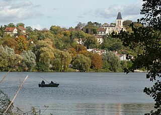
Herblay-sur-Seine is a commune in the Val-d'Oise department in the Île-de-France region in Northern France. It is located 20.2 km (12.6 mi) from the centre of Paris, in its northwestern outer suburbs, on the departmental border with Yvelines. It is twinned with Yeovil, England.

<span class="mw-page-title-main">Arrens-Marsous</span> Commune in Occitania, France

Arrens-Marsous is a commune in the Hautes-Pyrénées department in southwestern France.

<span class="mw-page-title-main">Bannalec</span> Commune in Brittany, France

Bannalec is a commune in the Finistère department in the Brittany region in northwestern France. Bannalec station has rail connections to Quimper, Lorient and Vannes. Bannalec is twinned with the Irish town of Castleisland.

<span class="mw-page-title-main">Kerpert</span> Commune in Brittany, France

Kerpert is a commune in the Côtes-d'Armor department of Brittany in northwestern France.

<span class="mw-page-title-main">Wy-dit-Joli-Village</span> Commune in Île-de-France, France

Wy-dit-Joli-Village is a commune in the Val-d'Oise department and Île-de-France region of France.

<span class="mw-page-title-main">Congerville-Thionville</span> Commune in Île-de-France, France

Congerville-Thionville is a commune in the Essonne department in Île-de-France in northern France.

<span class="mw-page-title-main">Calacuccia</span> Commune in Corsica, France

Calacuccia is a commune in the Haute-Corse department of France on the island of Corsica. It contains the Lac de Calacuccia, a hydroelectric reservoir, just south of the village of Calacuccia.

<span class="mw-page-title-main">Pont-Hébert</span> Commune in Normandy, France

Pont-Hébert is a commune in the Manche department in Normandy in north-western France. On 1 January 2018, the former commune of Le Hommet-d'Arthenay was merged into Pont-Hébert.

<span class="mw-page-title-main">Boissy-l'Aillerie</span> Commune in Île-de-France, France

Boissy-l'Aillerie is a commune in the Val-d'Oise department in Île-de-France in northern France.

<span class="mw-page-title-main">Bonneuil-en-France</span> Commune in Île-de-France, France

Bonneuil-en-France is a commune in the Val-d'Oise department in Île-de-France in northern France.

<span class="mw-page-title-main">Buhy</span> Commune in Île-de-France, France

Buhy is a commune in the Val-d'Oise department in Île-de-France in northern France.

<span class="mw-page-title-main">Champagne-sur-Oise</span> Commune in Île-de-France, France

Champagne-sur-Oise is a commune in the Val-d'Oise department in Île-de-France in northern France. Champagne-sur-Oise station has rail connections to Persan, Creil, Pontoise and Paris.

<span class="mw-page-title-main">Condécourt</span> Commune in Île-de-France, France

Condécourt is a commune in the Val-d'Oise department in Île-de-France in northern France.

<span class="mw-page-title-main">Jagny-sous-Bois</span> Commune in Île-de-France, France

Jagny-sous-Bois is a commune in the Val-d'Oise department and Île-de-France region of France.

<span class="mw-page-title-main">Saint-Witz</span> Commune in Île-de-France, France

Saint-Witz is a commune in the Val-d'Oise department in Île-de-France in northern France.

<span class="mw-page-title-main">Villaines-sous-Bois</span> Commune in Île-de-France, France

Villaines-sous-Bois is a commune in the Val-d'Oise department in Île-de-France in northern France. Villaines station has rail connections to Luzarches, Sarcelles and Paris.

<span class="mw-page-title-main">Villiers-Adam</span> Commune in Île-de-France, France

Villiers-Adam is a commune in the Val-d'Oise department in Île-de-France in northern France.

<span class="mw-page-title-main">Val Buëch-Méouge</span> Commune in Provence-Alpes-Côte dAzur, France

Val Buëch-Méouge is a commune in the Hautes-Alpes department of southeastern France. The municipality was established on 1 January 2016 and consists of the former communes of Ribiers, Châteauneuf-de-Chabre and Antonaves.

<span class="mw-page-title-main">Val-d'Aigoual</span> Commune in Occitania, France

Val-d'Aigoual is a commune in the Gard department in southern France. It was established on 1 January 2019 by merger of the former communes of Valleraugue and Notre-Dame-de-la-Rouvière.

References

  1. "Répertoire national des élus: les maires" (in French). data.gouv.fr, Plateforme ouverte des données publiques françaises. 4 May 2022.
  2. "Populations légales 2021" (in French). The National Institute of Statistics and Economic Studies. 28 December 2023.
  3. "Fiche Climatologique Statistiques 1981-2010 et records" (PDF) (in French). Météo-France . Retrieved August 28, 2022.
The dovecote, 17th century Colombier d'Haravilliers.JPG
The dovecote, 17th century