Harpalpur, Hardoi

Last updated

Harpalpur
Harpālpur
Populated place
Harpalpur block map.png
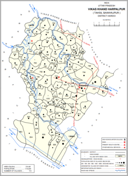
Map showing Harpalpur (#797) in Harpalpur CD block
India Uttar Pradesh location map.svg
Red pog.svg
Harpalpur
Location in Uttar Pradesh, India
India location map.svg
Red pog.svg
Harpalpur
Harpalpur (India)
Coordinates: 27°19′29″N79°50′22″E / 27.324631°N 79.839526°E / 27.324631; 79.839526 [1]
CountryFlag of India.svg  India
State Uttar Pradesh
District Hardoi
Area
[2]
  Total4.912 km2 (1.897 sq mi)
Population
 (2011) [2]
  Total8,822
  Density1,800/km2 (4,700/sq mi)
Languages
  Official Hindi
Time zone UTC+5:30 (IST)

Harpalpur is a village and corresponding community development block in Sawayajpur tehsil of Hardoi district, Uttar Pradesh, India. [2] It is located west of Sandi, on the road to Fatehgarh. [3] The main staple crops here are wheat, rice, [4] and maize. [5] Markets are held twice weekly. [4] [5] As of 2011, the population of Harpalpur is 8,822, in 1,544 households. [2] The total block population is 172,224, in 29,232 households. [2]

Contents

History

Around the turn of the 20th century, Harpalpur's main landowner was the Rani of Katiari, who held the village on a permanent settlement. [3] It had become the site of a police station, which was previously located in the neighbouring village of Palia. [3] As of the 1901 census, its population was 1,182, including 91 Muslims. [3]

The 1961 census recorded Harpalpur as comprising 3 hamlets, with a total population of 1,779 (968 male and 811 female), in 368 households and 214 physical houses. [6] The area of the village was given as 1,295 acres. [6] Amenities recorded at the time included a medical practitioner, a hospital, and a post office. [6]

The 1981 census recorded Harpalpur as having a population of 344, in 64 households, and covering an area of 497.38 hectares. [5]

Villages

Harpalpur CD block has the following 113 villages: [2]

Village nameTotal land area (hectares)Population (in 2011)
Saee 397.4459
Jeuri 539.1230
Barhauli 33.7622
Gauria Sisala 251.31,149
Gauria Pansala 164.80
Ghorhi Thar 355.81,885
Mubarakpur 91.1429
Bamh Rauli 414.12,346
Bhupatipur Nagar 276.41,763
Chatkapur 45.9451
Bamtapur Nand Bagh 317.21,230
Shahabuddinpur 449.22,277
Sanjhara 207.7410
Auhadpur 235.31,078
Kakrauaa 438.72,591
Padamlapur 139720
Aliganj Nan Kheriya 873.92,105
Nagriya Cut 128.5916
Kudha 162.9550
Arjunpur Sisala 474.94,387
Arjunpur Pansala 127.60
Sidheypur 80.40
Bhawanipur 80.1560
Molhanpur Pansala 202.50
Molhanpur Sisala 263.12,144
Surjoopur Durjana Sisala 287.11,580
Surjoopur Durjana Pansala 223.581
Tithi Gaon Sisala 190.52,235
Tithi Gaon Pansala 384.20
Bari (Barra) 400.71,811
Sirsa 85.41,514
Nagra Choudharpur 448.22,500
Mirgawan 318.12,242
Nagriya Sadhau 84.5569
Pithnapur 281.31,063
Muthauli 74.433
Mahsoolapur 122.52,210
Haraiya 89.7365
Mahua Koli 89.4562
Choudhariapur 253.6653
Sultanpur 70229
Jeuri Chandrampur 340.62,063
Barsana 169.8311
Newada 295.51,093
Khamhaura Pansala 135.50
Khamhaura Sisala 115.21,092
Gadnapur 135.9911
Khasaura 614.77,260
Surjupur 112850
Sildaspur 2.60
Shyampur 360.21,489
Behta Rampura 2472,061
Dharampur 409.43,286
Chaunpur 365.81,928
Barha Gaon 234.91,642
Nagra 2.50
Gangeypur 260.20
Rabiapur 81.8209
Kharagpur 89.6479
Bari 221.9583
Bundapur 63.7540
Saresar 131.7803
Karak Chamau 307.41,343
Satautha 797.63,992
Bhusehra 406.42,486
Malautha 559.14,432
Harpalpur (block headquarters)491.28,822
Roshanpur 439.42,052
Bansy 381.41,737
Kakra 716.35,746
Iknaura 315.32,165
Rani Khera 62.7989
Deorania 39.4259
Kathetha 203.42,517
Palia Sisala 5319,250
Palia Pansala 135539
Gadherha 44.6273
Mahdain Kalan 109.8505
Mahday Khurd 97.9546
Kiratpur 00
Ghatwasa 262.82,449
Bhatauli Dharam 407.82,709
Laluwa Mau 3193,039
Dhania Mau 420.22,005
Shekhapur Nagria Kadim 269.31,854
Shekhapur Nagria Jadid 269.30
Chanda Mohammadpur Sisala 350.42,819
Chanda Mohammadpur Pansala 90.60
Manduwdpur Narautha 360.4847
Kharuddinpur 218.61,304
Baran 323.41,171
Surjanapur 69.4327
Didwan 162.9480
Mastapur 147.8281
Parchauli 372.32,501
Dayalpur 421.92,534
Pura Anta 55.8490
Ismailpur 116.5756
Tikar 178.11,351
Poora Ratan 128.7723
Beerhijor 344.82,236
Gadanpur 2790
Bara Mau Sisala 278.81,534
Bara Mau Pansala 1,052.1622
Dhak Pura 275.71,304
Dahalitha 1,700.97,440
Murwa Shahabuddinpur 254.41,608
Ram Nagar 60471
Murcha 375.4753
Behta Lakhi 125.81,108
Alampur 158.7984
Arwal Paschim 707.65,925
Arwal Poorab 707.6397

Related Research Articles

<span class="mw-page-title-main">Todarpur, Hardoi</span> Populated place in Uttar Pradesh, India

Todarpur, also spelled Tondarpur, is a village and corresponding community development block in Shahabad tehsil of Hardoi district, Uttar Pradesh, India. The village has several schools and one clinic. It hosts neither a haat nor a mandi. The staple crops here are wheat and rice. As of 2011, its population is 3,846, in 603 households.

<span class="mw-page-title-main">Bharkhani</span> Populated place in Uttar Pradesh, India

Bharkhani is a village and corresponding community development block in Hardoi district of Uttar Pradesh, India. It has several schools, one clinic, and a public library, and there is a regular market as well as a weekly haat. A fair called Banshi Baba is held here on Chaitra Badi 30. The main staple crops here are wheat and rice. As of 2011, the population of Bharkhani is 5,681, in 888 households.

<span class="mw-page-title-main">Bawan</span> Populated place in Uttar Pradesh, India

Bawan is a large village and corresponding community development block in Hardoi district of Uttar Pradesh, India. It is located 10 km west of Hardoi, on the south side of the road to Bazpur-Naktaura and the Sai Ghat. Bawan was historically the seat of a pargana since at least the time of the Mughal Emperor Akbar, and it is also the site of a mela held in honour of Darshan Debi on the first Sunday of Bhadon, at a site called the Suraj Kund. The main staple crops here are wheat, rice, and gram. Markets are held on Mondays and Thursdays. As of 2011, the population of Bawan is 13,524, in 2,230 households.

<span class="mw-page-title-main">Satautha</span> Populated place in Uttar Pradesh, India

Satautha is a village in Harpalpur block of Hardoi district, Uttar Pradesh, India. The main staple crops here are wheat and rice. As of 2011, the population of Satathua is 3,992, in 727 households. The village lands cover an area of 797.6 hectares.

<span class="mw-page-title-main">Khasaura</span> Populated place in Uttar Pradesh, India

Khasaura is a large village in Harpalpur block of Hardoi district, Uttar Pradesh, India. It lies on the left bank of the Ramganga river, to the north of the road connecting Hardoi and Sandi with Farrukhabad. The village hosts a large market twice per week, on Wednesdays and Sundays. It deals mainly in vegetables.

<span class="mw-page-title-main">Kherwa Amjadpur</span> Populated place in Uttar Pradesh, India

Kherwa Amjadpur is a village in Sandi block of Hardoi district, Uttar Pradesh, India. It is located 8 km (5.0 mi) away from Sandi, which is the nearest city. The village has one primary school. The main staple crops are wheat and maize. As of 2011, its population is 752, in 231 households.

<span class="mw-page-title-main">Dasauli</span> Populated place in Uttar Pradesh, India

Dasauli is a village in Sandi block of Hardoi district, Uttar Pradesh, India. It is located 10 km away from Sandi, which is the nearest city. The main staple crops are wheat and rice. As of 2011, its population was 1,950, in 291 households.

<span class="mw-page-title-main">Nikari</span> Populated place in Uttar Pradesh, India

Nikari is a village in Sandi block of Hardoi district, Uttar Pradesh, India. It is located 8 km (5.0 mi) away from Sandi, which is the nearest city. The village has one primary school, and the main staple crops are wheat and rice. As of 2011, the population of Nikari is 1,878, in 283 households.

<span class="mw-page-title-main">Lamkan</span> Populated place in Uttar Pradesh, India

Lamkan is a village in Sandi block of Hardoi district, Uttar Pradesh, India. It is located 6 km away from Sandi, which is the nearest city. It is connected to state and national highways and has a sub post office and two primary schools but no healthcare facilities. The main staple crops are wheat and rice. As of 2011, its population is 3,734, in 577 households.

<span class="mw-page-title-main">Hariyawan</span> Populated place in Uttar Pradesh, India

Hariyawan is a village and corresponding community development block in Hardoi district of Uttar Pradesh, India. It hosts a market on Wednesdays and Sundays. The main staple foods here are wheat and rice. As of 2011, its population is 2,997, in 508 households.

<span class="mw-page-title-main">Kurseli</span> Populated place in Uttar Pradesh, India

Kurseli is a large village in Hariyawan block of Hardoi district, Uttar Pradesh, India. It is located north of the city of Hardoi, to the west of the main road to Pihani. Kurseli hosts a market on Mondays and Thursdays, and the main staple foods are wheat and rice. It has several schools and one clinic, along with five practitioners of traditional medicine. The village lands extend a long way to the south, and include a chain of jhils that ultimately drain into the Sai river. As of 2011, the population of Kurseli is 10,404, in 1,936 households.

<span class="mw-page-title-main">Tadiyawan</span> Populated place in Uttar Pradesh, India

Tadiyawan, also spelled Tandiyawan, is a village and corresponding community development block in Hardoi district of Uttar Pradesh, India. Located 14 km from the city of Hardoi, it hosts a regular market and hosts a Deviji festival on Chaitra Sudi 8 dedicated to worship of the goddess Devi. The village has two primary schools but no healthcare facilities. As of 2011, the population of Tadiyawan is 5,998, in 1,079 households.

<span class="mw-page-title-main">Asa, Hardoi</span> Populated place in Uttar Pradesh, India

Asa is a village in Tadiyawan block of Hardoi district, Uttar Pradesh, India. Located 3 km from the city of Hardoi, the village is connected to state highways and has several schools but no healthcare facilities. The main staple foods are wheat and rice. As of 2011, the population of Asa is 5,734, in 944 households.

<span class="mw-page-title-main">Pura Bahadur</span> Populated place in Uttar Pradesh, India

Pura Bahadur is a village in Tadiyawan block of Hardoi district, Uttar Pradesh, India. Located a few kilometres from the city of Hardoi, the village is connected to state highways and hosts a market on Wednesdays and Sundays. Pura Bahadur has two primary schools and a sub post office. There are no hospitals for humans, although there is a veterinary facility. The main staple foods are wheat and rice. As of 2011, the population of Pura Bahadur is 5,594, in 964 households.

<span class="mw-page-title-main">Japra</span> Populated place in Uttar Pradesh, India

Japra is a village in Tadiyawan block of Hardoi district, Uttar Pradesh, India. Located 16 km from the city of Hardoi, the village is not on any major roads and it has 3 primary schools but no healthcare facilities. The main staple foods are wheat and rice. As of 2011, the population of Japra is 3,633, in 555 households.

<span class="mw-page-title-main">Sursa</span> Populated place in Uttar Pradesh, India

Sursa is a village and corresponding community development block in Hardoi district of Uttar Pradesh, India. Located 14 or 15 km from the city of Hardoi, the village hosts a market on Mondays and Thursdays. The village has two primary schools and one clinic. As of 2011, the population of Sursa is 2,157, in 373 households.

<span class="mw-page-title-main">Ahrori</span> Populated place in Uttar Pradesh, India

Ahrori, also spelled Ahirori, is a village and corresponding community development block in Hardoi district of Uttar Pradesh, India. Located 24 km from the city of Hardoi, it hosts a regular market and hosts a Babaji festival on Asadha Sudi 15 dedicated to worship of the goddess Devi. The village has two primary schools and one clinic, as well as a public library and a sub post office. As of 2011, the population of Ahrori is 8,382, in 1,329 households.

<span class="mw-page-title-main">Kothwan</span> Populated place in Uttar Pradesh, India

Kothwan, also spelled Kothawan, is a village and corresponding community development block in Hardoi district of Uttar Pradesh, India. Located 8 km from the city of Beniganj, Kothwan hosts a Parikrma fair during the month of Phalguna where people gather for worship purposes. Vendors bring various items of merchandise to sell at the fair, including carpets, handloom cloth, glassware, earthen pots, toys, and sweets. Kothwan also hosts a market on Wednesdays and Sundays, which involves the sale of miscellaneous products. The main staple foods in Kothwan are wheat and rice. As of 2011, the population of Kothwan is 5,323, in 1,063 households.

<span class="mw-page-title-main">Bharawan</span> Populated place in Uttar Pradesh, India

Bharawan is a village and corresponding community development block in Sandila tehsil of Hardoi district, Uttar Pradesh, India. Located 23 km from Sandila, it hosts a market on Mondays and Thursdays and has four primary schools and one healthcare facility. The main staple foods are wheat and juwar. As of 2011, the population of Bharawan is 10,443, in 1,649 households.

<span class="mw-page-title-main">Hardoi, Raebareli</span> Village in Uttar Pradesh, India

Hardoi is a village in Maharajganj block of Rae Bareli district, Uttar Pradesh, India. Located on the road from Maharajganj to Bachhrawan, Hardoi historically served as the seat of a pargana and has a now-ruined fort built in the early 1400s under the Jaunpur Sultanate. As of 2011, its population is 2,308, in 415 households.

References

  1. "Geographic Names Search WebApp". Search for "Harpalpur" here.
  2. 1 2 3 4 5 6 "Census of India 2011: Uttar Pradesh District Census Handbook - Hardoi, Part A (Village and Town Directory)" (PDF). Census 2011 India. pp. 206–30. Retrieved 29 May 2021.
  3. 1 2 3 4 Nevill, H.R. (1904). Hardoi - A Gazetteer. Allahabad: Government Press. p. 203. Retrieved 29 May 2021.
  4. 1 2 Census 1971 Uttar Pradesh: District Census Handbook Part X-A: Village & Town Directory, District Hardoi (PDF). 1972. pp. 128–9. Retrieved 29 May 2021.
  5. 1 2 3 Census 1981 Uttar Pradesh: District Census Handbook Part XIII-A: Village & Town Directory, District Hardoi (PDF). 1982. pp. 172–3. Retrieved 29 May 2021.
  6. 1 2 3 Census 1961: District Census Handbook, Uttar Pradesh (36 - Hardoi District) (PDF). Lucknow. 1965. pp. 158, xciv-xcv of section "Bilgram Tahsil". Retrieved 29 May 2021.{{cite book}}: CS1 maint: location missing publisher (link)