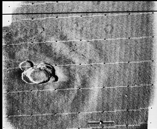
Situated in the Ódáðahraun lava field, Trölladyngja is the biggest of the Icelandic shield volcanoes, reaching a height of 1,460 metres (4,790 ft) above sea level, and rising almost 600 m (2,000 ft) above the surrounding desert and lava fields. It part of the Bárðarbunga volcanic system and has a volume of 15 km3 (3.6 cu mi) with some extensive lava flows to the north of Bárðarbunga.

A shield volcano is a type of volcano named for its low profile, resembling a shield lying on the ground. It is formed by the eruption of highly fluid lava, which travels farther and forms thinner flows than the more viscous lava erupted from a stratovolcano. Repeated eruptions result in the steady accumulation of broad sheets of lava, building up the shield volcano's distinctive form.

The Anahim Volcanic Belt (AVB) is a west–east trending chain of volcanoes and related magmatic features in British Columbia, Canada. It extends from Athlone Island on the Central Coast, running eastward through the strongly uplifted and deeply dissected Coast Mountains to near the community of Nazko on the Interior Plateau. The AVB is delineated as three west-to-east segments that differ in age and structure. A wide variety of igneous rocks with differing compositions occur throughout these segments, comprising landforms such as volcanic cones, volcanic plugs, lava domes, shield volcanoes and intrusions.

An active volcano is a volcano that has erupted during the Holocene, is currently erupting, or has the potential to erupt in the future. A volcano that is not currently erupting but could erupt in the future is known as a dormant volcano. Volcanoes that will not erupt again are known as extinct volcanoes.

Dhamar is a city in south-western Yemen. It is located at 14°33′0″N44°24′6″E, at an elevation of around 2,400 m (7,900 ft).

Ḥarrat Rahāṭ is a volcanic lava field in the Hejazi region of Saudi Arabia. In 1256 CE, a 0.5 km3 (0.12 cu mi) lava flow erupted from six aligned scoria cones, and traveled 23 km (14 mi) to within 4 km (2.5 mi) of the Islamic holy city of Medina; this was its last eruption. There were earlier eruptions, such as in 641 CE, which made finger-like flows to the east of the 1256 CE flow. It is the biggest lava field in Saudi Arabia. Nearby is Al Wahbah crater.

The Alligator Lake volcanic complex is a group of basaltic cinder cones and lava flows in south central Yukon. The upper part of the Alligator Lake volcanic complex consists of two well-preserved cinder cones capping a small shield volcano. They probably post-date the local Holocene glaciation. Lava flows from both cinder cones traveled to the north and were erupted simultaneously. Their compositions range from alkali olivine basalt to basanitic. Lava flows from the northeast cone are the largest extending 6 km (4 mi) from the cone and expanding to a width of 10 km (6 mi) at the terminus.
The Atlin Volcanic Field, also called the Llangorse Volcanic Field and the Surprise Lake Volcanic Field, is a group of late-Pleistocene to Holocene cinder cones that lies on the Teslin Plateau east of Atlin Lake, Canada. The largest volcanic feature is the 1880-m-high Ruby Mountain which has been partially dissected by Pleistocene and post-Wisconsin glaciation. Two basaltic cinder cones at the heads of Cracker Creek and Volcanic Creek lie within glacially dissected U-shaped valleys and may be of postglacial age.
Ruby Mountain, locally known as Old Volcano, is a cinder cone in Stikine Region, British Columbia, Canada, located 23 km (14 mi) northeast of Atlin and 6 km (4 mi) south of Mount Barham. A recent collapse on the volcano's eastern side created a large landslide which dissects this side of Ruby Mountain. The volcano is the largest feature within the Atlin Volcanic Field.

Marble Mountain-Trout Creek Hill volcanic field (MMTC) is a volcanic field located in Washington, US.

Jabal al-Tair Island is a roughly oval volcanic island in Yemen, northwest of the constricted Bab al-Mandab passage at the mouth of the Red Sea, about halfway between mainland Yemen and Eritrea. From 1996 until an eruption in 2007, Yemen maintained two watchtowers and a small military base on the island.

The Wells Gray-Clearwater volcanic field, also called the Clearwater Cone Group, is a potentially active monogenetic volcanic field in east-central British Columbia, Canada, located approximately 130 km (81 mi) north of Kamloops. It is situated in the Cariboo Mountains of the Columbia Mountains and on the Quesnel and Shuswap Highlands. As a monogenetic volcanic field, it is a place with numerous small basaltic volcanoes and extensive lava flows.

Volcanic activity, or volcanism, has played a significant role in the geologic evolution of Mars. Scientists have known since the Mariner 9 mission in 1972 that volcanic features cover large portions of the Martian surface. These features include extensive lava flows, vast lava plains, and the largest known volcanoes in the Solar System. Martian volcanic features range in age from Noachian to late Amazonian, indicating that the planet has been volcanically active throughout its history, and some speculate it probably still is so today. Both Mars and Earth are large, differentiated planets built from similar chondritic materials. Many of the same magmatic processes that occur on Earth also occurred on Mars, and both planets are similar enough compositionally that the same names can be applied to their igneous rocks.

Volcanism in Northern Canada has produced hundreds of volcanic areas and extensive lava formations across Northern Canada. The region's different volcano and lava types originate from different tectonic settings and types of volcanic eruptions, ranging from passive lava eruptions to violent explosive eruptions. Northern Canada has a record of very large volumes of magmatic rock called large igneous provinces. They are represented by deep-level plumbing systems consisting of giant dike swarms, sill provinces and layered intrusions.

The volcanic history of the Northern Cordilleran Volcanic Province presents a record of volcanic activity in northwestern British Columbia, central Yukon and the U.S. state of easternmost Alaska. The volcanic activity lies in the northern part of the Western Cordillera of the Pacific Northwest region of North America. Extensional cracking of the North American Plate in this part of North America has existed for millions of years. Continuation of this continental rifting has fed scores of volcanoes throughout the Northern Cordilleran Volcanic Province over at least the past 20 million years and occasionally continued into geologically recent times.
The Satah Mountain volcanic field (SMVF) is an extensive north-south trending volcanic chain in the Central Interior of British Columbia that stretches south of the Itcha Range shield volcano to northeast of Nimpo Lake. The chain is located on the Chilcotin Plateau, a major subdivision of the Interior Plateau that includes other nearby volcanic features. It forms a segment of the east-west trending Anahim Volcanic Belt, whose volcanic activity ranges in age from Miocene-to-Holocene.

The Sierra Chichinautzin volcanic field, also known as El Pedegral, is located in the Trans-Mexican Volcanic Belt, approximately 350 kilometres (220 mi) from where the Cocos Plate subducts beneath the North American Plate.
Jabal Yār is a small basaltic volcanic field in Saudi Arabia, near the border with Yemen. It is the southernmost (young) volcanic field in Saudi Arabia. The field is rich in olivine.
The mainly Quaternary Harra of Arhab is the northernmost, historically active volcanic field in Yemen. Also known as the "Sana'a-'Amran volcanic field", or simply the "Sana'a volcanic field", it has erupted in ancient times.
Harra es-Sawad, or the "Shuqra Volcanic Field", is a large trachybasaltic volcanic field that runs along the Gulf of Aden. Nearby is the city of Shuqrah.


